The boat is now passing the point where Geirangerfjord meets Synnulvsfjord.
The latter continues further into Storfjorden, which in turn extends all the way to the beautiful Sunnmøre coast and the Jugendbyen of Ålesund.
If you look North, you will be able to catch a glimpse of Åkernesremna, which has turned these village communities along the fjords upside down.
Because, on the mountainside over Åkerneset there is a large part of the mountain that is in danger of breaking away.
A landslide here would, in just a few minutes cause Hellesylt, Geiranger and other small villages along the way to be hit by waves of up to 40 metres high.
The local community have learned to live with the danger that is literally hanging over them.
Today there is a warning system, that is so good that a landslide would be detected well in advance giving the villagers time to evacuate.
However, this was not the case in the well know Norwegian disaster movie ‘the wave’ in which the warning system didn’t work as it should and the subsequent landslide caused monster waves that reached all the way up to the Hotel Union in Geiranger.
Geiranger, landscape in perfect harmony
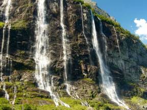
Surrounded by towering peaks and deep, glacial waters, Geiranger unfolds like a hidden gem at the end of the fjord. No matter which direction you arrive from, the view is breathtaking – waterfalls tumble down steep cliffs, and the village itself clings to the landscape in perfect harmony.
Once a remote farming community, Geiranger has become one of Norway’s most visited destinations. Cruise ships, hikers, and road-trippers all find their way here, drawn by the dramatic scenery and the promise of unforgettable experiences.
The Seven Sisters waterfall, lush green slopes, and winding mountain roads frame a village that still holds on to its roots, even as it welcomes the world.
With its rich history, natural beauty, and role as a hub for fjord travel, Geiranger is more than a place to see – it’s a place to feel.
The mountain farm Skageflå
Those who lived in the mountainside farms along the fjord many years ago must have had a head for heights.
We are now passing the mountain farm Skageflå which was vacated around 100 years ago.
It is idyllically located on a sunny mountain ledge 250 metres up the steep mountainside.
Skageflå is one of 10 disused fjord farms on the Geiranger Fjord.
Its spectacular position and the exposed and difficult path up, makes the farm the best known of them.
As you can appreciate, it was not without danger to either live on or get to the farm.
Today, the path that runs to Skageflå is safe. It has been repaired and secured in stages, over the last 150 years.
In the past, the hardy fjord folk who lived there had to learn to deal with the dangers that lurked there.
The children attended school in Geiranger in stretches of a few weeks at a time, and both learnt and partook in the demanding farm work when they were at home.
The smallest children were secured with a rope so that they couldn’t get too close to the dangerous cliff edge.
Today the farm is used as a holiday home and a tourist destination, but it is not for those who are afraid of heights.
the bridal veil "Brudesløret"
For around two weeks every year, a very special phenomenon occurs right where we are passing now.
Melt water from the high Sunnmøre Mountains reaches its climax here when the water rushes down the mountain and creates what is known as the bridal veil.
The waterfall of the same name then produces a beautiful fine spray, which together with the wind fans the water across the mountain road like a beautiful transparent bridal veil.
If the sun is shining it creates an incredibly beautiful rainbow effect, which gets the tourists’ cameras clicking.
There are seven other places in Norway that have waterfalls called the Bridal Veil, but this is the most famous and is ranked amongst the 50 biggest waterfalls in Norway.
Directly above and next to the famous waterfall the mountain farms Megardsplassen and Horvadrag hang on two narrow ledges almost 500 metres above sea level.
The last tenants left the farm in 1900, but considered moving back the year after, but by then an avalanche had taken all the houses and washed them into the fjord.
Had they still been living there; they too would have followed their house down to the bottom of the fjord.
Flydalsjuvet and Geiranger skywalk
There are few places that can entice with such beautiful untouched nature.
And for that reason Geirangerfjord is on the prestigious UNESCO list of world cultural and natural heritage sites.
Here, you can also find Norway’s most spectacular viewpoints, regardless of which road you approach the village on. From the centre of the village, you can follow the road up the valley to two of them, Flydalsjuvet and Geiranger Skywalk, Dalsnibba.
Flydalsjuvet lies in the middle of the valley and is equipped with glass plates, protrusions, and benches allowing visitors to make the most of the picturesque background of Geirangerfjord, where cruise ships look like small toy boats in the background.
From here you can also stare several hundred metres down into the crashing Maråk river as it makes its way down the valley to the centre of Geiranger.
Right at the top you will find the magical Geiranger Skywalk at Dalsnibba, 1500 metres above sea level.
From there you will enjoy Europe’s highest and most beautiful fjord view. The platform is built out over the mountainside and with a freefall drop of 500 metres you get the feeling that you are floating, even though of course, you are completely safe on the solid platform.
All the viewpoints are a part of the National Tourist Route which has the aim of strengthening Norway as a travel destination.
We are now passing the farm Matvika, transelated the food bay ,to the north, and as the name suggests, this is a particularly fertile spot in the fjord.
There were people living here right up until 1961, who subsisted on what the earth provided.
The location was particularly favourable for the growing of fruit and large amounts of apples, pears and plums were harvested here.
There were even more exotic fruits such as tomatoes and apricots grown here, but it was the goats that provided the main source of income.
The farm had hundreds of goats who ran and jumped up the mountainside right up to the summer farm which was a thousand metres up the hillside.
There the goats were milked according to traditional methods and the enterprising milkmaids produced both white and brown cheese from the milk.
There was little winter fodder down by the fjord, and the resourceful farmers therefore made their very own zip line which was an amazing 1200 metres long for the transportation of hay.
To put that into perspective the longest zip line in the Nordics today is in Flåm and is 1381 metres long.
The Matvika zip line was reportedly built by as up to as many as 70 men from across the whole area.
How many of them took the tour all the way down themselves is not known, but undoubtably it would have been an experience.
The Cross on the Mountain Wall
Once upon a time, there was a witch who was engaged to a handsome fellow—until he left her for a beautiful maiden from Geiranger.
He proposed, and soon the groom, his bride, and the entire wedding party set sail into the fjord toward Stranda Church.
The witch was far from pleased. When she saw the wedding procession depart, she filled a bowl with water in her kitchen.
She spun the bowl round and round, breathing and panting furiously. Out on the fjord, the wind grew stronger, the waves swelled—and when the witch overturned the bowl, every boat in the wedding party capsized, sinking with all aboard.
This story is recorded in the local village chronicles. It’s said that the parish priest rowed out into the fjord and painted a white cross on the mountain wall, low by the water’s edge—the very one we’re passing now to the north.
And so, this place came to be known as Korsen—"The Cross."
In Norway there were around 300 people sentenced to death for witchcraft and wizardry, but the witch that this story refers to, was not one of them.
You will shortly see a gorge that reveals itself in the steep mountainside around 1200 metres up.
It is said that it was the devil himself that made it, it therefore goes by the name the devil’s or hell’s column.
Legend says that the devil sat on top of the mountain looking at the stars, but he fell asleep and when the sun began to rise, he got up in such a hurry to make it home that he took large parts of the mountainside with him.
On the opposite side of the fjord, right down by the fjord edge, you can find the Syltavika Farm, and if you lift your gaze 400 metres above it, you can see the Blomberg Mountain farm.
Both these farms, and many more in this fjord, have been restored and taken care of by the voluntary organisation the Friends of Storfjord.
Their unique work contributes to preserving the history and in addition creates wonderful experiences for current and future generations.
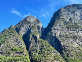
Now pay attention. Can you see the troll in the mountainside up there?
If you look closely, you might spot a nose, a hunched back, or even two large eyes staring out over the fjord. These natural rock formations have inspired troll legends for generations. In Norwegian folklore, trolls were powerful but dim-witted creatures who lived in the mountains and forests—and turned to stone if touched by sunlight.
Many peaks and boulders bear their names to this day. When the fog rolls in and the wind howls through the valleys, it’s easy to see how such stories came to life. The landscape is wild and mysterious, letting the imagination roam free. Maybe that’s why the troll is still watching us—from deep within the mountain, silent and still.
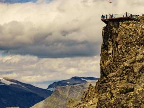
Ørnesvingen (The Eagle’s road)
Do you see the road dancing up the steep mountainside?
That is Ørnevegen, The Eagle’s road, today it is stamped as a National Tourist Route, which takes motorists through 11 tight hairpin bends 620 metres over sea level into the small fjord village of Eidsdal.
The road was first opened in 1955 and gave Geiranger a much-needed year-round road, it got its name because it passes through an area which is home to lots of eagles.
Then as today, the eagles with their enormous wingspans glide majestically high in the air studying the tourists below.
From day one, motorists were fascinated by the beautiful view which revealed itself at the top of the road.
Soon travellers from the whole of Norway were stopping on the turns to enjoy the spectacular views and before long tourists from Europe and the rest of the world made their entrance on motorbikes, cars, campervans, and busses.
The authorities gradually made things more accessible for the tourists, and improved traffic safety by regulating and extending the upper hairpin bend.
It has the name the ‘Eagle’s wing’ and is perhaps Norway’s most famous viewpoint.
Today, tourists can walk out onto a glass floor, where they can see the world heritage fjord under them whilst at the same time having a panoramic view towards Geiranger and the seven sisters waterfalls.
Maybe they can even see the trolls in the rockface on the opposite side of the fjord. Can you?
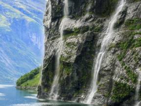
The seven sisters and the suitor
Have you heard about "Friaren", the suitor who laid his sights on seven wild unmarried sisters, only to have his offers turned down by each and every one of them?
Many believe that he became so depressed that he turned to the bottle and sought shelter in the waterfalls on the mountainside that we are now passing, and that is why according to local legend the waterfall has its characteristic bottle shape.
On the opposite side of the fjord, you can see one of Norway’s most photographed landmarks, the characteristic "sju søstre", or the Seven Sisters, waterfalls.
From a distance, they look like the hair of seven women, hence the name.
The waterfalls are an impressive sight, especially when the snowmelt is big and constantly feeding the waterfalls which on average are in free fall for an incredible 250 metres.
And believe it or not, on a small mountain shelf, nearly right at the top of the seven sisters, is the abandoned and landslide prone farm of Knivsflå.
It is a very popular tourist destination with its fantastic and spectacular view over Geiranger fjord, where at the same time you can get a feel for its unique history and how it must have been to live there in times gone by.
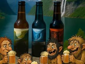
What do the Suitor "Friaren, The seven sisters, "De sju søstre" and The devil’s column, "Helvetesgjølet", have in common? They are of course all tourist attractions along the Geiranger fjord.
But in addition, they are also three tasty beers in the range of beers produced by the Geiranger brewery.
The tourist village has a long tradition of beer brewing.
All the farms had their own beer that was brewed for Christmas, often leading to a dispute over who had brewed the best beer. Therefore, a particularly serious competition was arranged at the Hotel Union where impartial people with a good palette for beer judged the beer of the year.
The winner was crowned ‘Beer King of Geiranger’ a title up there with other prominent awards.
The Geiranger brewery has developed these traditions further and produces exciting new beers that are available in supermarkets, outlets, and restaurants around the country.
Hellesylt, contrasts and history
In these majestic surroundings, where mountains plunge into the fjord and light dances across the landscape, you’ll find Hellesylt – a village full of contrasts and history. At the heart of it all, the powerful Hellesylt Waterfall crashes down between the houses, a natural landmark for everyone arriving by boat or car.
In earlier times, life here revolved around farming, fishing, and fjord transport. Today, Hellesylt is a key crossroads, with roads leading to Stryn, Ørsta, and Stranda, and a ferry connection onward to Geiranger.
Tourists have been coming here for more than a century. While cameras and clothing have changed, the desire remains the same – to experience the force of the waterfall, the calm of the mountains, and the beauty of nature.
Perhaps you are wondering why people settled in these impassable places?
It sounds a little bit strange, but in Norway there was in fact a lack of space from the 1500s onwards.
During that time, Geiranger was so populated that people could not find houses or land.
The solution was for people to move to where they could be self-sufficient, often with their closest family.
Therefore, we often see settlements along most of the green lungs of the fjord and farms right up the valley sides.
The alternative was either to move further inland or out towards the coast.
Inland there was not much fishing and along the coast not much of an opportunity for hunting, but here in the fjords there were both.
Life along the fjord and up the sides of the valley, of course offered challenges, but also had many high points.
Every Christmas the dark fjord was full of rowing boats on their way to Geiranger with lanterns on their sterns.
This must have been a beautiful and ceremonious sight.
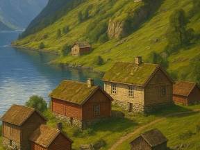
On these farms they lived at one with nature for many generations, but gradually the life became too hard and from the beginning of the 1900s the emigration began.
Today, most of the farms are in use as weekend homes or are rented out to tourists.
Now you're about to join an experience you'll never forget. We'll stop right by the Frieren waterfall and collect the pure water so you can taste it.