Foto: Kjetil Schjølberg
Molde - the Atlantic Road - Kristiansund - Molde
This trip goes from Molde via Norwegian Scenic Route the Atlantic Road - often described as the world’s most beautiful road – to Kristiansund and back to Molde!
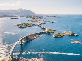
The Atlantic Road connects Averøy with the mainland via a series of small islands and islets spanned by a total of eight bridges over 8274 meters. The road is a national tourist route.
https://fram.trekksoft.com/en_GB/activity/80459/rundtur-til-nasjonal-turistveg-atlanterhavsvegen-kristiansund
To find more content and listen to free audio guides, download the Guide To Go app.
Molde - the Atlantic Road & Kristiansund (round trip)
Points of interest
Atlanterhavstunnel
Photo: tk.no
You are now most likely on your way either up or down the Atlantic Ocean Tunnel which is an undersea tunnel in the region of Nordmøre.
The tunnel first opened in December 2009 and connects Kristiansund to Averøy, along County Road 64.
Before the tunnel opened, there was a ferry connection between the island and Kristiansund.
The tunnel is 5,780 meters long and 250 meters deep, with a 10% gradient at its steepest.
Staveneset Lighthouse
Photo: sulafyr.no
The Staveneset Lighthouse first became a working lighthouse in 1842.
The only employees were the lighthouse keeper and his worker.
Between 1847 and 1854, Hustadvika was struck by several unusually strong and devastating storms. Reports mention extreme weather and gigantic waves crashing onto houses, and shipwreck survivors who managed to climb ashore close to the lighthouse.
One of the reports describes seawater entering chimneys and flowing into houses, and windows broken by strong winds and hail.
In 1894, the lighthouse was rebuilt with more cuts and colour sectors. Additional improvements were made in 1907 when the old light was replaced with a new fourth-order lens.
The Staveneset Lighthouse was modernised in 1953 with the construction of a new keeper's house and the installation of a generator to ensure the supply of electricity. In 1976, the lighthouse was automated.
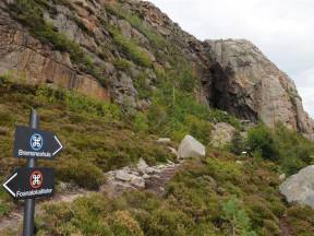
Bremsneshatten
Photo: peakbook.org
The Bremsneshatten ("the Bemsnes hat") mountain is a special landmark with a magnificent 360-degree view from its summit. A marked pathway leads up to the summit of "the hat" from County Road 64, from the car park in Djupbukta on the northern side of the mountain.
When you turn right, the directions will be indicated with small green arrows. The pathway runs along a ridge directly towards the Bremsneshatten mountain.
The Bremsneshatten mountain also has several caves, including the Bremsnes Cave on the southern side of the mountain, marked as a separate point of interest. The cave is Norway's largest and extends 80 meters inside the mountain.
Traces of the Fosna culture have been found in this cave dating back nearly 10,000 years.
Bremsneshola
On the southern side of Bremsneshatten mountain, you will find the Bremsnes Cave. Traces of the Fosna culture have been found in this cave dating back nearly 10,000 years.
The cave is Norway's largest and extends 80 meters inside the mountain. In the old days, it is thought that the cave was most likely used as a hideout. This meant that the artefacts found there were those of outlaws and castaways.
As is the case of many caves, the Bremsnes Cave is also a place of dramatic tales and legends. One of them tells the story of a dog that went farther and farther into the cave, and then re-emerged on the other side with most of his fur ripped off.
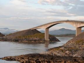
Gjemnessund Bridge
The Gjemnessund Bridge is a 1257 metre-long suspension bridge over Gjemnessundet, and is part of the E39. The bridge starts at Bergsøya, at the far end of Tingvollfjord.
Bergsøya is the largest island in the municipality of Gjemnes. The island's highest point is Brannhaugen, which is 284 meters above sea level. There was previously only a ferry connection to the mainland.
Since Kristiansund's mainland connection, Krifast, was opened in 1992, Bergsøya has become the region's traffic hub. The Freifjord Tunnel, the Bergsøysund Bridge and the Gjemnessund Bridge all extend from here.
Gjemnessundbrua was Norway's longest suspension bridge until the Hardanger Bridge was opened in 2013. Its main span is 623 metres. It has a clearance of 43 meters, which means that quite large ships can sail under it.
There are bird nests on all 21 spans. Black-legged kittiwakes have made it their home, so they evidently think the bridge is a suitable place to rear their young. Black-legged kittiwakes are medium-sized gulls recognisable by their black wing tips.
Their droppings cause damage to the concrete, so the highways department has tried to deter the birds from nesting. This proved an impossible task, so modifications were made to allow the birds to keep breeding here. An elastic membrane has been laid over the concrete to protect it from their droppings.
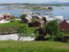
Averøy Municipality
Photo: Kjetil Schjølberg, Roger Ellingsen / Statens vegvesen
Averøy is a municipality in Nordmøre, Møre og Romsdal. The municipality consists of several island chains, among which Averøya is the largest.
The municipality's administrative centre is in Bruhagen on this main island.
Kristiansund is to the east, Gjemnes to the southeast and Eide to the southwest. The nearest towns are Kristiansund and Molde. The population is between 5,500 and 6,000, most of whom live by the sea, spread out over a large area. This means less than 20% of the population lives in the urban centres.
The island is a place of rich historical and cultural heritage, and the locals are often referred to as Pekailla.
This was probably because many of the island's inhabitants had names starting with the letters P and e, such as Per, Peder, Peter, etc.
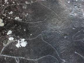
Rock carvings in Søbstad
Photo: averoy.kommune.no
In Søbstad images are carved into the rock, and it is easy to recognise what many of them represent: whales, boats and birds.
However, we can only speculate as to the actual meaning of the artwork and what rituals took place here, as we will never be able to know that with absolute certainty. An unknown people lived in this area, and are reaching out to the present from thousands of years ago through their art.
The rock carvings were discovered about 30 years ago.
Rock carvings are like life nerves carved into the rock and in Søbstad it is possible to witness 17 such signs and symbols. Søbstad is where the glacial stream formed potholes at the end of the Ice Age, about 10,000 years ago.
When the ice caps melted and the ground rose, these ondulating rocks emerged from the sea. People must have noticed the smoothly polished rock formations. Some of these monuments, created by nature itself, became sacred places.
The carvings were made here for this very reason — the rock was considered sacred.
Along the coast from Romsdal to Troms, whales are a common sight. If the carvings were made when the tide was low, then the whales—wet and reflecting the sunshine—would have been playing between the waves carved into the rock and the real ocean waves.
The images carved into the rock represent hunting scenes and depict the large mammals found on land: moose, deer and reindeer.
The animals depicted were probably hunted. The people behind the rock carvings were hunter-gatherers and fishermen. However, the animals were equivocal symbols and an expression of far more complex representations.
In addition to hunting and food, they also represent society and religious faith.
The rock carvings in Søbstad are located 12 to 16 metres above today's sea level. According to archaeologists, this means there are two possible time periods for their creation: the rocks were dry land for a short period in the Late Stone Age, i.e. from 8,500 to 9,000 years ago.
After that, the melting ice caps lead to a higher sea level, flooding the area, and leaving the rocks under water once more. Then the rocks re-emerged in the Early Stone Age, about 5,000 years ago.
Many have focused on the Early Iron Age since in some places, the whales appear with other figures that we can place with more certainty in that time period. However, according to recent research, some elements in other parts of the rock carvings imply that we can't exclude the earlier period.
In terms of cultural history, the transition from the Early to the Late Stone Age does not seem to be significant in this area, but between the earliest and the latest dates there is a 4,000-year span.
Around this time, there was a profound evolution in the use of tools, ways of living and beliefs. Most likely, there were distinct peoples here with their own languages and cultures.
In the same way, there are important transitions within the Early Stone Age. The rock carvings in Søbstad were obviously created before agriculture became more established towards the end of the Early Stone Age.
Not far from the rock carvings in Søbstad, there is also a burial mound and a stone circle.
These are far younger than the rock carvings. The tradition of marking graves with stones dates back to the Late Bronze Age, about 1800 - 1000 B.C.
The shape of the burial mound indicates that it might date back to the last part of the Late Iron Age, i.e. 200 - 550 A.D, but the dating method is considered uncertain.
Pilespisser/Arrowheads
Photo: Kristen Vorpvik @ flickr.com
After crossing the bridge you’ll arrive at Langøya island, you will notice the Pilespisser (arrowheads) monument to the right of the car park. The monument was erected to honour the memory of the Langøysund Agreement of 1040 A.D. Thanks to which Norway got its first Magna Carta.
King Magnus called for an agreement to be reached with the farmers along the coast. Following tough, but peaceful negotiations, the King and his men reduced their demands and renounced certain rights they had previously enforced, but which were not granted by law.
At the same time, legal changes were voted in, this was a breakthrough for democracy. The beacon-shaped sculpture by the artist Kristian Blystad represents a common weapon from that era — an arrowhead.
In the sculpture, the arrowhead has been removed, leaving only a contour for the light to shine through. This is a reference to the victory of values such as negotiation and democracy.
Arrowheads can also be found in the coat of arms of Averøy municipality. From the Pilspisser monument, there is a pathway heading northwest towards Tjyvlohaugen (Arctic skua's mound) and Ørnhågen (eagle's mound).
The names of the mounds date back a long time, but both Arctic skuas and eagles can be observed in the area.
Kårvåg
Photo: Jarle Wæhler / Statens vegvesen
Kårvåg is a village of about 300 inhabitants on Averøy island, near the Atlantic Road.
It has a primary school, a kindergarten, a petrol station, retail outlets, shops and restaurants.
Håholmen
(Photo: Grete Kongshaug / Statens vegvesen)
Håholmen has been a fishing village focused on klippfisk (dried and salted cod) since the early 1700s and was initially a dynamic community based on trade, fishing and maritime transport. Håholmen Sea Cottages today include a hotel, a conference centre, a café and a restaurant where guests move freely between the buildings — just like people did traditionally in vibrant fishermen's communities.
Håholmen has a heritage worth preserving — this used to be a central meeting place for fishermen, sailors, salesmen and travellers. Its history and location on one of the most unsheltered parts of the Norwegian coastline adds to the unique character of the island.
To a great extent, the 25 buildings have remained largely unchanged since the 18th and 19th centuries.
This island of merely 50,000 m2 creates a natural separation between the open sea and the shipping lane on the outside. The landside of the island provides a beautiful natural harbour, protected from all kinds of weather.
It was the adventurer Ragnar Thorseth and his wife Kari, who first came up with the idea of turning Håholmen into a hotel and conference centre. Together, they ran Håholmen until 1998.
The Hall of Saga Siglar houses the Viking ship Saga Siglar, which Thorset used to circumnavigate the globe, and numerous souvenirs from this and other adventures. Exhibitions about old and recent history of Håholmen are also gathered here.
The visit ends with a viewing of a film about Ragnar Thorseth's many adventures. The island is only accessible by boat. Check out the link if you want to book a hotel room, a table or just a ride across to visit the island.
Moldegård
(Photo: Romsdalsmuseet / Digitalt Museum, moldegaard.com)
In front you now, you can see Moldegård. Originally, the estate was called Molde, supposedly from Norse "moldar", plural for "mold". Molde became the home of Captain Johan Fredrik von Beverlov, commander of the Romsdal military Company.
He settled there and acquired the main farm, in approximately 1677. During his time, the suffix -gård (literally "farm") was used to differentiate between the growing town and the surrounding farms, including Reknes.
Moldegård was the County Governor's house from 1705 to 1729, in addition to two short periods in the 1750s, and was supposedly the inspiration for Ibsen's 1886 drama Rosmersholm.
The main farm house has been the property of the Møller family since 1789 and was registered in the cadastre of Bolsøy until the two municipalities were joined in 1964.
Eldhusøya
Photo: Harald Christian Eiken, Jiri Havran / Statens vegvesen
The walking path around Eldhusøya island offers a splendid view.
The path is suitable for everyone and is open every day, all year round.
Don't let bad weather stop you since experiences in bad weather can be at least as intense as in good weather.
The café is normally open during the summer season, but to be sure please check the link in the app.
Storseisundbrua
Photo: Harald Christian Eiken, Magne Flemsæter, Jiri Havran \ Statens vegvesen
The Storseisund Bridge is the longest and perhaps most well-known of the 8 bridges of the Atlantic Road.
The bridge is a cantilever bridge with a length of 260 metres and largest span of 130 metres.
It is among the most iconic tourist attractions in Norway, and is frequently used in commercials, films, etc.
The BBC's popular series Top Gear has also filmed an episode on this bridge and the Atlantic Road.
Atlantic road
Photo: Jarle Wæhler / Statens vegvesen
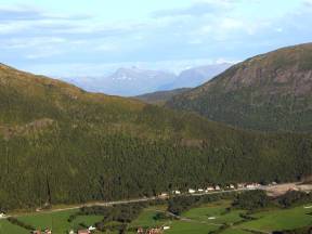
The Atlantic Road runs along a stretch of sea at the very edge of the Atlantic Ocean, offering a scenic drive across the many bridges and islands. Often described as the world's most beautiful road trip, this section of County Road 64 is part of the National Tourist Route stretching from Vevang in Eide to Kårvåg on Averøy.
The construction of the Atlantic Road began in 1983 and was completed in the summer of 1989. In 2005 it was voted Construction of the 20th Century. The road replaced the ferry route between Ørjavik and Tøvik which until then had connected the two municipalities.
The entire installation, more than 8 km long and consisting of eight bridges with a combined length of 891 metres, runs across multiple islets and reefs.
The Atlantic Road ranks number 8 of the most visited nature-based tourist attractions in the country, with several hundred thousand visitors each year. The road has also been the setting for numerous commercials, and several car producers — among which Lamborghini — have filmed commercials here to promote their latest models.
The entire National Tourist Route called the Atlantic Road is 36 km long and connects Kårvåg to Bud. The road offers a unique experience with its breathtaking coastline and original design, both of the road itself, the bridges and multiple installations along the way.
This place is equally spectacular to visit in inclement and windy weather, as it is on a bright and sunny day.
Look west, towards the vast open sea and Hustadvika, a stretch of the Norwegian Sea known for its many reefs and dramatic climate. In calmer weather, it is possible to spot both seals and whales in the area.
Between Vevang and Bud, southeast of the Atlantic Road, experience the lush coastal landscape with heaths and bare rocks along the unsheltered and open coastline of Hustadvika.
The experience is intense and provides an insight into a region exposed to many different types of weather: here you risk facing strong winds, or – when the weather is good – a sunset that will leave a lasting impression on your mind.
Myrbærholmbrua
Photo: Jarle Wæhler / Statens vegvesen
The Myrbærholm Bridge connects Skarvøya to Eldhusøya via Flatskjæret.
In 2010, bridges specially dedicated to fishing opened on Myrbærholmen. From these you could try to catch some fish from the famous Atlantic Road.
Unfortunately, there is no option to rent fishing gear here at the moment, so you would need to bring your own.
Or you could watch other people fish here.
In the strong tidal currents, there is a good chance of catching cod, pollock, mackerel and saithe from the clear waters.
Skarvøya
(Drawing: Ragnhild Folland)
You are now on Skarvøya island. Together with Strømsholmen islet, this is the most southwesterly island on the Atlantic Road.
Here you will find Gallery Skarvøya with a small café — a perfect pit stop to stretch your legs and admire the view.
Strømsholmen Seasport Center
Photo: stromsholmen.no
Strømsholmen Sjøsportsenter (Strømsholmen Sea Sports Centre), is a place for adventures above and below the water.
Since 1981, the professional dive center Strømsholmen offered a unique blend of thrilling adventures to visitors from around the world.
The Sea Sports Centre is situated on the Atlantic Road and offers accommodation, fishing, diving, seal safaris, sightseeing tours etc.
Brunvoll Motor factory
The Brunvoll quarter now consists of apartments and some business activity, but was until recently the location for the Brunvoll factory.
The Brunvoll Bros.’ factory was founded on Harøya by the brothers Andreas and Anders Brunvoll. The workshop’s primary purpose was to repair and build motors for fishing vessels. Brunvoll also produced diesel engines and propellers.
In 1918 production was moved to Molde when the brothers bought Engstrups Motorfabrikk, located at the ferry port.
In 1965 Brunvoll Motorfabrikk delivered its first side propellers, also known as thrusters. This product’s technology would turn out to be the bright future of the company.
Over the years, they have delivered thousands of advanced propeller systems to thousands of ships.
Many Norwegian industrial companies chose to produce in low-cost countries, but Brunvoll has chosen to go against the flow and manufactures their products in Norway.
In the period 2014-14 Brunvoll moved all their activities in Molde to Årø, by the airport, including a state-of-the-art competence centre. Brunvoll is among the largest private companies in Molde with about 330 employees in Molde. In addition, the company has facilities in Volda and Dalen.
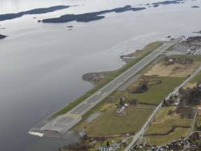
Årø Airport
(Photo: fjordnorway.com)
Molde’s airport Årø was financed by the Molde municipality and inaugurated in 1972. A lengthy discussion whether there should be a common airport for Romsdal and Nordmøre ended with the development of two airports, one in Molde, the other in Kristiansund.
Årø serves more than 500,000 passengers annually.
Fylkesvei 64 goes through the Fannefjord tunnel just under the runway.
Over time the airport has undergone a series of improvements to meet the needs of both leisure and business travelers. The largest development was the extension of the runway from 1601 to 1980 meters. The additional runway was added during summer 2008.
Malme
The village Malme has about 500 inhabitants located at the end of Malmefjorden, the innermost part of Frænfjorden.
The village has a significant production facility for refrigeration systems used in industry, fishing, and aquaculture.
The name Malme comes from the Norse name "Malmr", which means 'sandy moor' or 'gravel field'.
The fjord is a favorite place for ice skating fans. As the fjord freezes over during winter, it turns into a fantastic skating rink which extends for several kilometers.
When conditions are safe, it is possible to spend many hours on the ice and enjoy both nature and the food you bring along for a nice day out.
Sylte
The village Sylte has just a little over 300 inhabitants. It is located next to Sylteelva about six kilometers east of the city center of Elnesvågen (Fræna municipality).
Here you will find a residential area surrounded by farmland looking down toward Sylteosen and Fræneide, and a shieling cottage up toward Kvannfjellet, the highest mountain in Fræna municipality.
Sylte has its own elementary school, linked with Malme School, four kilometres away. First to fourth graders attend Sylte School, while fifth to seventh graders go to Malme School.
Sylteelva is a popular destination for anglers.
Kvernberget Airport
Kvernberget Airport is located in Nordlandet, one of the four islands that comprise Kristiansund. It was opened in June 1970.
The number of travellers using the airport has increased since the Kristiansund mainland connection (Krifast) was opened in 1992, making it easier for the residents of the municipalities around Kristiansund to get to the airport.
The airport is a base for transporting personnel to the Haltenbanken oil field off central Norway.
Archaeological excavations were carried out in connection with the expansion of the airport in 2007. The archaeologists made sensational discoveries.
Settlements were discovered from people who lived here 11,300 years ago! The material found showed close links to the North German/southern Scandinavian Ahrensburg culture, suggesting kinship or common ancestry.
The Stone Age culture here in Nordmøre is called the Fosna culture. This culture existed just after the end of the last ice age. Their settlements were quite small. They lived in small tipi-like leather tents. These people were nomadic hunter-gatherers.
Many flint arrows and blades have been found here. At the airport, 4300 artefacts were discovered in one location alone. Fosna sites have also been discovered at many other locations on Nordmøre.
Bergtatt adventures
(Photo: fjordnorway.com)
We are now not far away from a 40 km system of mining tunnels that penetrate Bergtatt mountain on eleven levels. The mining operations started here in 1938, providing marble for the paper industry in Norway and Sweden.
A few years ago the idea arose to open parts of the mountain as a tourist attraction. Within a short time this plan was implented. Bergtatt, also called «Fjellets mørke – the darkness of the mountain» - is already a reality.
A trip to Bergtatt begins in daylight as you travel up the mountain side. When you reach the entrance to the mine, the road disappears into the big tunnel leading you further inward. For a while you will be surrounded by darkness before you get a glimpse of distant light.
You can then board a barge resting on water that is glass-clear. As you proceed it gets darker before something lights up in front of you. Then quite suddenly four large chandeliers illuminate the marbled walls of a troll cave with plenty of space for both audience and artists.
You are guaranteed to have an unforgettable experience at Bergtatt.
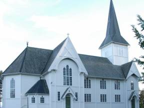
Eide Church
(Photo: Visit Norway)
Eide Church is an aisleless “long church” completed in 1871. It is a wooden building with seats for 340 people. The church organ was made in Norway by Norsk Orgel og Harmoniumfabrikk. The organ’s pipes have sounded since 1977.
The chimes of the church bells are much older. They started ringing in 1871. Then as now entrepreneurs understand the value of sponsoring – an inscription in one of the bells says: „Given by Kristiansund Sparebank 1871“.
Around 3500 people live in this church’s parish.
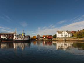
Kristiansund
Kristiansund is a vibrant and beautiful city, famous for its opera performances and its salted cod. It is located on the stormy Atlantic coast, but it has a temperate natural harbour that lies between four islands.
Today, the islands are linked with bridges, but in the past, inhabitants who wanted to cross from one area of the city to another had to take a 'Sundbåt'. These boats are still in operation and have been since 1876.
Kristiansund gained its position as Norway's main point of export for salted cod in around 1850. The merchants' wealth was reflected in the beautiful houses that were built in the centre of Kristiansund.
The city was bombed in April 1940. About 800 houses burned down, but some of the shops were saved. Modern architecture and colourful buildings rose from the ruins.
Kristiansund is today a communications hub and a retail and business centre for the whole of Nordmøre, and since the 1980s, the oil industry has been important for the city, attracting oil refineries and the chemical and pharmaceutical industries.
Kristiansund municipality has approximately 24,000 inhabitants, most of whom live in the town itself. (2019)
Eide Stone industry
(Photo: Gunn K. M. Skotheim)
Here, between the open sea and the high mountains, lies idyllic Eide, roughly midway between the towns of Molde and Kristiansund. The settlement was called Nordic rock territorNordic rock territory", when Eide had its own municipal status.
Mining and stone masonry have long traditions and are significant to the area industry. The largest section of the Norwegian stone-processing industry is located here. Workshops and carpentry are important industries as well.
Modern retail establishments and a well-developed public sector serve the community. A fare number are also employed in agriculture and fishing.
The area offers various exciting nature experiences, for example Hustadvika, one of Norway's most wild and beautiful coastal strips.
The Atlantic Road is an attraction itself. A great experience both in stormy weather and sunshine. Connected through eight bridges, this spectacular road stretches along the coastal landscape.
Visnes Chalk
(Photo: kommunenvar.no)
The big limestone quarry Visnes Kalk AS makes it their business to refine a type of marble known for its white color and high lime content.
The founder of the company, Iver R. Eide, grew up at Eide. At the age of 18, he traveled to Hamar where he trained to become a mason. He later worked as a mason for the regional railroad company.
When Ålesund burned down in 1904, it was decided that the city should be rebuilt with non-flammable material.
This was an excellent windfall of opportunity for Iver Eide and his group of masons to work in Ålesund. Iver Eide learned that there were significant resources of both white and colored marble on Visnes in Eide.
This area was close to the sea with good harbor conditions as well. Iver entered into contracts with all the land owners in the area and secured delivery of cut stone.
That's how the stone industry started in Eide – all because of the Ålesund fire in 1904!
Stone blocks from Visnes were cut for several large marble buildings in the area. Ålesund church, Rønneberggården in Ålesund and Bondeheimen in Trondheim are some of them.
Nowadays calcite from Visnes is still widely used as a construction material as well as in the paper industry, as an abrasive, in agriculture, as a pigment, in pharmaceutics and sandblasting.
Notre Dame Cathedral in Paris was sandblasted with marble from Visnes as this particular marble's soft structure minimizes damage to the underlying original but is strong enough to clean surface contamination.
Gautvik stone industry
Gautvik Steinindustri was started in 1935 by the brothers Alfred and John Gautvik. The company is one of the oldest stone quarries in the country.
Raw material used in the local stone production is imported from India, Africa, Italy, Spain, Finland and Sweden. Stone from the mountains of Norway is also used; primarily natural stone from the regions around Larvik, Støren, Fauske, Otta, Oppdal and Alta.
In addition to the production of gravestones, they specialize in the design and manufacturing of counter tops.
The company has invested a great deal in order to stay at the forefront of their industry. Their speciality is employing a mix of modern technology along with experience and traditional craftsmanship.
Vevang
Vevang is a small village located by the Atlantic Road - next to the ocean.
Vevang has its name since pre-Christian times and consists of "ve"meaning "sanctuary" or "holy place" and "vang"“, which means field.
Several marked rocks and graves dating back to the newer Stone Age were discovered here. The village also features a number of bunkers from the Second World War when the Nazis occupied Norway.
Among the islets and reefs at Vevang you can find a 90 meter long marble installation. The man behind the artwork, Jan Freuchen, named his sculpture "Columna Transantlantica" - the Transatlantic Column.
The artwork consists of 39 parts spread around the landscape. This somewhat controversial work of art resembling the shape of a worm is made of real Italian marble. The artwork curves along the terrain and stretches out towards the open sea by the Atlantic Highway.
Frei
Frei municipality was merged with Kristiansund in 2008. The municipality's old administration centre was in Rensvik, and the main road to Kristiansund passes through this village.
Around the island of Frei are idyllic small islands and islets. Along the way you can see hillocks surrounded by woods and small green meadows.
Highway 70 runs along the east side of Bolgvatnet, Kristiansund municipality's largest lake. Until around 1980, Bolgvatnet served as the main water source for Kristiansund and Frei. The water level is 66 metres above sea level. In the middle of Bolgvatnet lies a small islet called Rastholmen.
On the west side of the lake we can see Freikollen, rising to 629 meters above sea level. This is the highest mountain in Kristiansund municipality. A rock type called gabbro abounds on Freikollen. This rock is tough and resistant, which enables the formation of high mountains and cliffs.
From the top of Freikollen there is an incredible view to Kristiansund town and the outer parts of Nordmøre. It is a popular destination. About 20,000 people take the walk up here every year. It is also the site of an uphill race called 'Freikollen Opp'.
Frei church is located on the south of the island. There is a memorial here of a battle that took place in 955. The battle was between Håkon the Good (Haraldsson) and the Eirikssons, who were the sons of Håkon's half-brother Eirik Bloodaxe. There are several graves and standing stones at Freihaugen and Freistranda near the church.
Batnfjord
Batnfjord is part of Gjemnes municipality, and is a ten kilometre-long fjord extending from Batnfjordsøra and into Tingvollfjord. Farming and fishing have been a way of life here for a long time.
The route along the fjord passes one farm after another, and one can also see the farms on the other side of the fjord. This agricultural area extends past Batnfjordsøra and farther up the valley.
Batnfjordsøra is the administrative centre of Gjemnes municipality, which has a population of around 2629 inhabitants. (2019)
Every autumn, there is a big agricultural fair at Batnfjordsøra, 'Dyregoddagene'.
Around 200 exhibitors from all over Norway come to the fair, and the area teems with life. There are activities and entertainment for both adults and children. It's an agricultural adventure for the whole family.
At the fair you can see many different kinds of livestock such as sheep, cows, goats and pigs, but also birds and even alpacas, a new area of investment for Norwegian farmers. You can ride a horse, or try your hand at various traditional crafts. New agricultural machinery and tractors are on display, and farmers share experiences with each other.
Food stalls are set up, selling everything from good, old-fashioned Norwegian 'lefse' (a kind of pancake) and generous servings of real farm food, to modern cuisine and, of course, cakes and ice cream.
Røbekk Church
Røbekk Church, which was inaugurated in 1898, is a neo-Gothic Swiss-style wooden church.
This means that the architecture is an imitation of the Gothic style, with pointed towers and arches, but in a more modern form.
In Norway, wood was the most common material used when building churches by the end of the 19th Century. Churches were often white-painted, so Røbekk church is also typical in this regard.
The church was designed by Gabriel Smith.
The building is usually described as a long church ('langkirke'), but is more cruciform in shape. It has a west tower. The choir is multi-sided. In the corners between the choir and the wooden frames are small sacristies. The altarpiece is from 1897.
The interior was repainted when the church was restored in 1964.
There is seating for 300 people in Røbekk church. It is part of the Church of Norway, and in the parish of Molde, which comes under Møre diocese.
There is a new, modern building next to the old, white Røbekk church. This is the Røbekk church centre, built in 2017, a new building which has enabled Røbekk church to become more active in the cultural life of the community. Here, less formal meetings, theme nights and concerts are arranged.
Omsund Bridge
Looking west from the Omsund Bridge we can see Kristiansund, a small city with the Atlantic in the background.
The Omsund Bridge connects Nordlandet to Freiøya. The new bridge and the old one are close to each other. The old bridge is from 1940, and is a listed structure, so will not be removed. The new bridge was completed in 1981.
The old Omsund Bridge has a total length of 200 metres. It is a two-sided truss bridge, and dates from World War II. The bridge was commissioned in April 1940, but not officially opened because the country was invaded by German forces. When Kristiansund was bombed in late April 1940, the bridge was crucial for evacuation of the city.
German aircraft tried to bomb the bridge, but it was not damaged. The Omsund Bridge was finally officially opened in 2005, no less than 65 years after its completion. Today, the bridge is open to pedestrians.
The new bridge is a bridge for car traffic. This is a prestressed concrete bridge with a length of 292 metres, and the longest span is 100 metres. The bridge is part of Highway 70.
Occasionally one can see anglers with their fishing rods under the bridge.
Freifjord Tunnel
The Freifjord tunnel runs under the sea from Frei to Bergsøya. The tunnel is part of Krifast, Kristiansund's mainland connection. At its deepest, the tunnel dips to 130 metres below sea level. Its total length is 5086 metres. The Freifjord Tunnel was opened in 1992, at which time it was the world's longest undersea road tunnel.
In the Viking Age, great power struggles took place over who had the right to be king of Norway. Harald Hårfagre had gathered Norway into one kingdom around the year 880, but after he died his sons fought over who should rule. Harald Hårfagre had sons with several women, and each son had an equal right to the throne.
In the year 955 there was a big battle on the south end of Frei between the descendants of Harald Hårfagre. This battle is known as the Battle of Rastarkalv, which is the name of a field near where the church at Frei stands today.
The combatants at Frei in the year 955 were Håkon the Good, Harald Hårfagre's son, and the sons of his half-brother, the Eirikssons, who came up from Denmark with a large army. Håkon had the smaller army, but he had the support of the local peasants, led by Egil Ullserk of Frei.
The result of the battle was that Håkon the Good won, thanks to Egil Ullerk's peasant army.
A historical play is performed up here some summers, but not every year. The play is called 'Rastarkalvspelet'.
The Furset mountain
Fursetfjellet straddles the municipalities of both Molde and Gjemnes. The E39 between Molde and Kristiansund runs along this small mountain pass, which only reaches a height of 250 metres above sea level.
Here the terrain is hilly, with open marsh areas, small ponds, and forests of pine and mountain birch.
In summer, the area is great for cycling and hiking. You can hike across the open terrain or on car-free dirt roads. There are signposted trails. In winter, many people ski here. Skiing contests are arranged for both adults and children. At Fursetfjellet there is a surface lift for skiers.
Parking is available, and the place is a great starting point for several pleasant mountain walks both in summer and in winter. The prepared ski trails go right up to the tree line.
The highest peak is Raudheia, at 669 metres above sea level. The cairn at Raudheia marks the border between Molde and Gjemnes and between Romsdal and Nordmøre. The views here are fantastic. Facing south, you can see the Moldefjord and the mountain peaks from the west, to Trollheimen in the east. To the north are the fjords and mountains of Nordmøre.
One of the hiking routes up to Kleivevatnet has been made suitable for those with disabilities.
Oppdøl Hospital
Oppdøl Hospital is a psychiatric hospital a that opened in 1913.
The hospital was built up as a self-sufficient small community with its own farm, power generator, water system, kitchens, and bakeries, as was common for such institutions at that time.
A large number of original artefacts remains from the earliest years the hospital was in operation, including medical equipment, work produced by patients, restraints and photographs. In addition, there is a large collection of agricultural machinery and other equipment used on the hospital farm.
New buildings were gradually added. At its height, the hospital accommodated 500 patients.
In the 1980s, Oppdøl psychiatric hospital was integrated with the county hospital in Molde. The capacity was reduced to just 60 day-care patients and several of the buildings fell into disuse.
In 2014 Oppdøl was chosen as the new location for the Nordmøre and Romsdal county hospital. The new hospital is scheduled to be completed in 2024.
Fannestranda and Villa Retiro
For a long time, Fannestranda has been a popular location for the summer villas of wealthy merchants from Kristiansund.
Villa Retiro was built around 1875 as the Kristiansund consul Christian Johnsen's summer residence on Fannestranda.
The trend at the time was to build these summer villas in scenic surroundings. Newly-rich merchants from Kristiansund created a paradise here at Fannestranda in the late 1860s. Summer villas lay like pearls strung out along the avenue.
Christian Johnsen had been in the Buen Retiro Park in Madrid in his youth. He had been overwhelmed by the beauty of the park, but was turned away because it was closed to 'ordinary' people. There and then, he decided to create an equally beautiful park when he became a rich man, and that that park should be open to all.
Consul Christian Johnsen indeed became very rich, and duly created a summer villa with an adjoining park. He called the property Villa Retiro. Everyone was allowed into the park to relax and admire beautiful sculptures, fountains, exotic flowers and trees.
A children's playground, croquet court and gymnasiums were set up. Everything in the park was made available for both the poor and the rich.
Today, the old park is dilapidated. But Johnsen's idea of a park where everyone is welcome lives on and the property is still a recreational area for the people of Molde. Not long ago, a diving tower was set up through a public/private partnership.
Molde council has created a man-made beach on Retiro, with a pleasant green area beyond. Visitors are welcome.