Komiža is a younger settlement than nearby Vis, and its name probably comes from the expression Com Issa, which means "next to Issa". The oldest written record of Komiža dates back to 1145, although it is likely that the settlement existed even earlier, with a Benedictine abbey at that time.
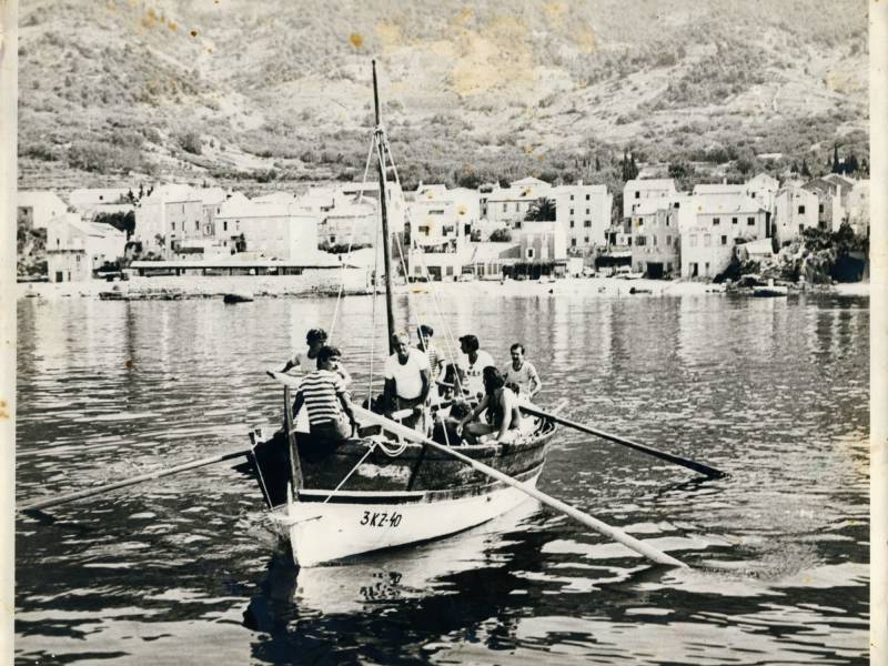
During the Venetian Republic, Komiža belonged to the Hvar municipality and developed rapidly thanks to fishing. The fish catch was so rich that it enabled the construction of churches, defensive towers and large stone houses. In the 19th century, under Austrian rule, Komiža became an independent municipality and an important island center. At the beginning of the 20th century, it had almost 4,000 inhabitants, a well-maintained port and several fish processing factories, the most famous of which was Fratelli Mardešić.
After World War I, a period of economic decline began. Although Vis belonged to the Kingdom of SHS, the rich fishing areas around Palagruža ended up under Italian rule, which hit Komiža's fishermen hard. Many then left the island and moved to California, where they continued their fishing tradition.
World War II brought new changes. After the Italian capitulation in 1943, Vis and Komiža became an important stronghold for partisans and allied forces. A military command and an allied airport operated on the island, and the people of Komiža actively participated in the resistance.
After the war, the island was declared a military zone, which interrupted the development of tourism and economic life. Komiža lost its status as a municipality and the ferry connection with Split, and the population decreased.
Changes came only after Croatia gained independence. With the departure of the army in the early 1990s, the island opened up to the world again. Komiža regained its status as a municipality in 1993, and became a city in 1997. Today, it relies on tourism and the legacy of its fishing past, which continues to shape the identity of the place.
Visit of Pope Alexander III.
There is a moment in the history of Komiža that stands out as special and unrepeatable, an event that connected this small community of fishermen and farmers to the highest peak of the Christian world. It is about the visit of Pope Alexander III, which took place in the 12th century, at a time when the Adriatic was an important maritime route and the scene of numerous historical encounters and conflicts.
On his journey to Venice, Pope Alexander III sailed the sea accompanied by ten galleys. After long days of sailing, on March 9, 1177, on the very day of Ash Wednesday, he landed on Palagruža. This remote islet, which for centuries served as a landmark for fishermen from Komiža and the wider Adriatic, became a place of historical significance that day.
A reception was held on the plateau of Mala Palagruža, and the place where the Pope stopped has since been called the Pope's Field. That name has been preserved through the centuries, passed down in tradition and in the collective consciousness, as a reminder of the event that connected this corner of the Adriatic with the highest spiritual authority of Europe at that time.
For Komiža and its people, that visit had a special meaning. With his arrival, Pope Alexander III made Komiža the first Croatian place to be visited by a pope. This gave the small fishing village, located on the edge of the Adriatic, its place in the great history of Europe.
Although the visit was short, the story of that day has been passed down for centuries. The Pope's Field has remained a permanent reminder that even the smallest places, thanks to a combination of circumstances, can become part of a larger historical story. For the people of Komiža, it was a moment of pride and confirmation of their connection with the great events of that time.
Imagine sailing the sea that was once helmed by heroes and merchants, a sea that preserves memories of myths, legends and real historical events. This is exactly the sea route known as the Route of Diomedes, named after the hero of Homer's Iliad - Diomedes, who, according to legend, found refuge on the shores of the Adriatic after the fall of Troy.
This sea route connects the Italian Gargano Peninsula with the Croatian Hylian Peninsula, namely the Punta Planka ridge near Šibenik. During the ancient and medieval centuries, numerous ships passed through it, and at the very heart of this route was the island of Vis (ancient Issa) - once the largest crossroads of Adriatic sea routes and the origin of urban life on the eastern coast of the Adriatic.
Old records, in which legend and history merge into one, and numerous archaeological finds on the island and in its underwater world, testify to its rich past. Net weights, bronze hooks, coins with dolphin images and mosaics with sea motifs have been found on Vis – clear evidence that the sea has always been life, destiny and inspiration here.
The famous Komiža falkuša, unique fishing boats from the island of Vis, also sailed on Diomedes' Route. Carried by the winds of the maestral and southerly winds, they set off towards Palagruža, returning to Komiža with barrels of salted sardines. It was precisely the harmony of the winds and the sea that enabled the thousand-year continuity of navigation along this route.
The Greek colonists brought to Vis not only the art of shipbuilding and seafaring, but also a fishing tradition that has survived to this day. For this reason, Diomedes' Route is not seen only as a historical line on a map, but as a living story about the sea, people and the wind.