This audio guide will give you stories and facts from different places and events in Romsdalen. Enjoy the tour as the stories are being told when you approach different areas where history has left its mark.
To find more content and listen to free audio guides, download the Guide To Go app.
Romsdalen
Points of interest
Åndalsnes
Here, surrounded by majestic mountains, deep and lush valleys and emerald green rivers, lies Åndalsnes, or Tindebyen which is full of spectacular experiences.
The town was also at the centre of one of the second world war’s largest battles, during which the whole of Norway’s gold reserve was at stake. In dramatic fashion, Norwegian and English soldiers together with hundreds of heroic volunteers managed to save the Norwegian gold and cash reserves, whilst howling German bombs squealed around them leaving the whole town in ruins.
Both the town and the steadfast people rose up again and to this day exist as a hub between the fantastic Norwegian mountain experiences both in Summer and Wintertime. The idyllic fjord centre has all you need and more.
We recommend the spectacular walk up the Romsdalstrappene to the Rampestreken viewpoint, which literally hangs out 8 meters in the air, giving you an eagle’s eye view over Åndalsnes and the beautiful Romasdal fjord. On your way down again we recommend taking the award winning Romsdal Gondola for all of you without a fear of heights.
And if you should hear some rough guitar riffs or some banging dance tunes, then maybe Raumarock or another of Åndalsnes’ famous music festivals is taking place.
Sport Angling Rauma
Several decades before sports angling became popular in the Rauma area, stories are told about the English Lord Beresford and his friend William Bromley-Davenport who came to Veblungsnes on the yacht Coral Queen a day in June 1849.
As soon as they saw the estuary of the Rauma river they visited the post master to inquire about the possibilities for salmon fishing. They were advised to move up the river, to Fiva, which at the time was owned by a young girl, Marianne Løchra.
In a letter to his father, Willaim describes his experiences from fishing in Rauma:
"…after 14 pleasant days by Romsdalsfjorden, where we in a river called Rauma caught nearly 330 salmon - an enormous quantity, and more than has ever been caught here even with a fishing net over a whole summer.
It is strange that these people don't learn fly fishing, since their existence is almost entirely dependent on the fish they catch.
As we gave away almost all the fish, except what we needed ourselves, we were welcome quests, and a large number of these poor farmers gathered around us and screamed with joy as we pulled salmon after salmon out of the river.
They though it was some kind of magic. Many of them assured us before we started that it was impossible to catch this big salmon with such simple equipment and angles."
William later returned to Romsdalen and established a home here by buying Fiva in 1862. To this date, Fiva is owned by his successors, carrying his name.
Fiva-ruta
En vinterdag i 2018 står den spanske Kilian Jornet på toppen av fiva-ruten, en rute som ble etablert av klatrepioneren Arne Randers Heen i 1931.
Selv om Kilian har klatret opp i likhet med mange andre eventyrere, har han en lagt mer ekstreme plan for turen ned fjellveggen.
De finnes en rekke brattkjørere har tenkt samme tanke som Kilian, men de andre har latt det bli med tanken. Å kjøre ski ned en klatrerute er meget komplisert og krever de helt riktige snø forholdene for å lykkes. Heldigvis stemmer alt denne dagen.
Fra toppen kan en sikte dalføre 1600 høydemeter lengre nede, de første 200 meterne antar han er på mellom 55-60 graders helning, og det bratteste henget han noen gang har kjørt.
Her er prisen for feil, livet selv. Videre fortsetter Kilian ned i en 400 meter smal «korridor», før de 1000 siste meterne gjenstår. På grunn av lengden på ruta er snøen forskjellig gjennom de ulike partiene, og disse store endringen i snøforholdene gir nedkjøringen en ekstra dimensjon, forklarer han selv.
(Photo: wikipedia)
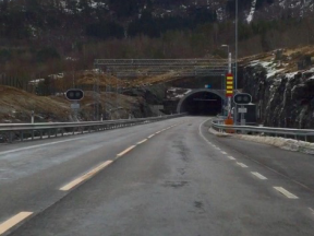
You are now crossing the Stigfossbrua bridge on county road 63 which passes above the Stigfossen waterfall in Trollstigen. The bridge and the road were opened by King Haakon VII on July 31st 1936.
The construction of the bridge started in 1933 and the construction of the walls was completed in 1934 and 1935.
On one of the large stones put up along the side of the road, one can read "Stigfossbrua 1935" carved into the rock.
Trollstigen Cafe
(Photo: Reiulf Ramstad Arkitekter AS, Jiri Havran / Statens vegvesen)
At the top of of the sharp turns from Isterdalen, you will find the Trollstigen plateu.
Hre you will find a service building with a café, souvenir shops and toilet facilities. The café and shops are normally open from mid-May to September.
By the service building there are beautiful water mirrors, bridges, and paths to the viewpoints where you can see the winding road, impressive waterfalls and the wild and stunning nature.
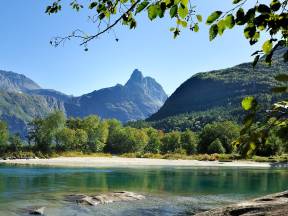
Trollveggen and Romsdalen Valley
(Photo: Øyvind Heen - Visitnorway.com)
The Romsdalen valley is long and narrow with majestic towering mountains on either side.
Along the valley floor in a wild and beautiful setting runs the foaming salmon river, Rauma. At Verma, the Rauma goes through a 30-40 meter high gorge and forms the waterfall Slettafossen.
Scandinavian rock climbing started in the Romsdal mountains, which boast some of the world's most difficult climbs.
At 1,000 metres, Trollveggen, the Troll Wall, is Europe's tallest vertical, overhanging rock face.
On the opposite side of the valley, the Romsdalshorn peak towers to a height of 1,555 metres. Romsdalshorn is a very popular climbing site for Norwegian as well as international climbers.
The Romsdalen mountains are also popular among base jumbers. However, from the late 1980s base jumping from Trollveggen has been illegal, after a number of serious accidents with risky and expensive rescue operations.
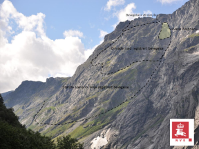
Mannen
På vestsiden av Romsdalen kan du se en tindenål formet som en stor and. Fra dalbunnen ligner silhuetten mest på en mann, noe som har gitt fjellet kallenavnet Mannen.
Sent på høsten i 2014 ble det slått full alarm i Romsdalen, da geologene fikk rapport om økt bevegelse i deler av fjellpartiet. Et fjellskred var nært forestående, og truet med å endre livene til menneskene som bor og ferdes nede i dalføret.
Skredet vil kunne komme til å krysse dalbunnen, å dermed skape en naturlig demning for elven med en påfølgende fare for flom. Mens verdens øyne ble rettet mot den overhengende faren, ble lokalbefolkningen evakuert og togtrafikken innstilt.
Først da vinterkulden igjen satt inn, stabiliserte fjellpartiet seg. Dette er nå blitt et årlig fenomen som finner sted hver høst, i det nedbøren finner vei ned i fjellsprekkene.
Enkehoppet
I midten av 1980-årene kom det i stadig økende grad eventyrlystende basehoppere til Romsdalen. Med økt aktivitet økte også risikoen for at noe skulle gå galt.
Den 7. juni 1984 var den amerikanske filmskaperen «Carl Boemish» på plass oppe på den 1600 meter høye toppen «Stabben». Ingen hadde noen gang våget å hive seg utfor den karakteristiske toppen før.
Boenish sprang utenfor kanten, men noe gikk galt og han omkom i det han traff fjellveggen ikke lagt fra sprangstedet. Konen til Carl, Jean som var vitne til hendelsen, hedret mannen sin ved å gjøre et nytt hopp fra Trollveggen to dager senere. Hoppet som ble dekket av flere internasjonale medier, ga det navnet «enkehoppet».
The Golden Route
Trollstigen is part of the Otta - Geiranger - Valldal - Åndalsnes - Dombås road which is called The Golden Route. Since 2005, Trollstigvegen has been one of the roads selected for the project National Tourist Routes. The project's slogan is Safe and Beautiful, meaning that all stops and picnic areas should look harmonious in relation to the nature and landscape.
The road's highest point is 850 metres above sea level, at Alnesreset. This was the location of the restaurant Trollstigheimen which was destroyed by an avalanche. It was never rebuilt.
The road was renovated between 2005 and 2009 in order to adapt to the increasing number of tourists. This included safety measures against stone avalanches, new rest stops and viewpoints, as well as souvenir shops.
The traditional small huts that used to sell souvenirs were removed, at the same time as a new facility with a café and a souvenir shop opened in the summer of 2009.
The road is surrounded by several mountain tops which are more than 1,000 metres high. Stigbotnhornet and Bispen are among the most famous. Dronninga and Kongen ('The Queen and The King') ; are to the north west. Trolltindene ('The Troll Peaks') ; with Trollklørne ('The Troll Claws') ;, and the backside of Trollveggen ('The Troll Wall') ; in the north east. The mountains and the many summits in Romsdal are popular among mountain climbers.
There are several marked trails, most of which are quite easy to hike, while others require climbing.
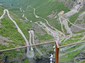
Plattingen
(Photo: Per Kollstad, Jarle Wæhler / Statens vegvesen)
Plattingen is the name of the platform that sticks out over the mountain edge and hovers 200 metres above Trollstigen.
It provides a spectacular view of the majestic landscape.
The platform has a different viewpoint depending on how brave or prudent you are.
The construction is made of steel and glass, and protects against bad weather and winds. Plattingen was designed by architect Reiulf Ramstad Arkitekter AS.
There is a short hike along the walking trails and stairs up to the viewpoints.
Første basehopp fra Trollveggen
En fin julidag i 1980 var finnen Jorma Öster på plass i Romsdalen. Han hadde som mål å gjøre noe ingen før hadde gjort, å hoppe i fallskjerm med Romsdalsfjellene som utgangspunkt.
Han søkte råd hos fjellvante folk i lokalbefolkningen, for å finne det mest sikre stedet å hoppe fra. Valget falt på Bruraskaret.
Med 800 meters fritt fall, hev Jorma seg utenfor toppen den 23. juni. Det spektakulære hoppet til finnen, ble raskt kjent over hele verden, og markerte starten på basehoppkulturen i Romsdalen.
Norwegian Mountaineering Center
Norsk Tindesenter attracts mountain climbers and regular tourists alike. Its main focus is on Norway's mountaineering history. Inside the center, you can start your visit with a cinematic experience allowing for floor-to-ceiling movie viewing.
Here, stunning trekking films combined with short historical narratives take you on an exciting adventure trip.
The center has a number of interesting installations showing different aspects of the climbing sport, and the driving forces motivating mountaineers. Both children and adults are invited to learn and participate interactively.
Real stories have been dramatized and old equipment displayed alongside so you can study the challenges of the climbing pioneers. If you feel up to it, you can test your own climbing skills.
Norway's highest indoor climbing wall – Carl's Hall – is here at Norsk Tindesenter. It has routes up to 21 meters.
Norsk Tindesenter also has its own children's bouldering cave suitable for children from 3 years of age and upwards.
Gulltransporten
Natten til 20 april i 1940 ble Norges gullbeholdning fraktet på denne jernbanen. Gullet som hadde vært på reise siden starten av krigen var på nesten 50 tonn, og var på sin siste fastlandsreise før det hele skulle fraktes ut av landet.
Dette var for å redusere risikoen for at gullet skulle gå tapt på havet. Det ble bestemt at lasten skulle deles i flere sendinger. Fire dager senere var den første forsendelse klar, og 8 tonn gull ble lastet ombord i den britiske krysseren HMS «Galatea», som var kommet fra England med ferske kampstyrker.
Med det samme Krysseren hadde langt til kai, gjorde den vendereis tilbake til England. Den første delen gullet var nå reddet. De tyske styrkenes raske fremrykking i Gudbrandsdalen gjorde i imidlertid at de involverte fant det nødvendig å flytte restene av gullet, før flere båttransporter til England kunne organiseres, og Molde ble det neste målet for Norges gullreserver.
Raumabanen
Reisen mellom Åndalsnes og Dombås er kanskje Norges fineste jernbanestrekning. Linjen ble åpnet i 1924, og gir togpassasjerene en fantastisk opplevelse med skjønn natur og spennende historie.
Norsk Museumstog startet med sommerkjøring fra cruiseskipene med damplokomotiv og ærverdige gamle trevogner.
Prosjektet fikk mye oppmerksomhet, ikke minst i media, siden det på spesielt tørre sommerdager ble tent en rekke små skogbranner av glør fra fyrkjelen.
På det verste kjørte brannbilen parallelt med toget opp gjennom Romsdalen. Det ble bestemt at damptoget var et litt for ustabilt prosjekt og derfor ble det stanset. Fra sommeren 2008 ble de igjen fart i turisttogene i Rauma. Men denne gangen med nye og moderne tog.
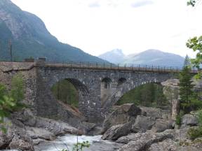
Kylling Bridge and Vermafossen
Photo: David Hasselberg og Erlend Garåsen
Kylling Bridge is the largest stone bridge on the Rauma railway., the railway between Dombås and Åndalsnes. The bridge is located right next to the farm Kylling in Verma in Romsdalen and crosses the Rauma river. Kylling bridge represents a very important cultural heritage for transport in Møre og Romsdal.
The construction of the bridge is a brilliant example of beautiful Norwegian engineering. The size of the bridge and the artistic challenge it represents has made it one of Norway's most famous stone bridges.
The building started in September 1913 and was completed 8 years later, during the winter of 1921. The bridge is 76 meters long and is built in granite from the mountain close by.
The stone had to be of good quality to withstand the pressure and strain of the railroad, and each stone had to be adapted to the user structure. The bridge is self-supporting and has a span of 42 meters. The altitude above the river is 59 meters. The main pin is 42 meters, and the tenpins are ten and eight meters, built with a fall of 0.8%.
The bridge is probably the most famous and most photographed railway bridge in Norway.
Fra øst til vest
Du har kanskje lagt merke til at landskapet har endrer seg. Østlandets slake vidder og rolige flyer går over i dramatiske skarpe tinder og egger som ofte kjennetegner vestlandet.
Terrengforskjellene skyldes ulik berggrunn, klima og landheving. I øst finner man yngre og mer næringsrike bergarter. I vest har landet hevet seg mer etter istiden. Dette henger sammen med nedbørmengden, og gjort at elvene har fått større fall og mer kraft til å grave seg ned i terrenget.
Elver som tidligere rant østover, munner nå ut i de kjente vestlandsfjordene på grunn av denne erosjonen.
Shipyards Vestnes
If you happened to travel through this area around the end of the 19th century, you would have seen several shipyards along the fjord.
Shipbuilding has a long tradition in Vestnes. However, most of the former companies are now just a part of the history. Hammeraas, Salthammer, Stenødegård, Helland, Ødegård, Aas, and Vestnes are names that still make people in the area think about boat construction. Boats and ships of all sizes were once constructed and built in this area.
One of the first most significant Norwegian boatbuilders was Lars Jensen Hammeraas, who was responsible for the construction of one of the largest wooden ships here toward the end of the 19th century, the full rigged ship Herman Lehmkul.
It was 214 feet long and as tall as a three-story house. In fact, the boat was so large that they had to reorganize the factory area in order to get enough space for the building process.
Stuguflåten bru
The construction of the Stuguflåtbrua, or Stuguflåten bridge, was started in 1919 and was completed at the end of 1923. The bridge is made of stone, and if you look closely, you can see traces of the World War II sabotage attempt.
During World War II, the Raumabana was an important railway of the German supply lines in the Romsdal valley. Operated by Special Operations Executive (SOE), a unit of the British special forces, Operation Fieldfare was launched in March 1944. The operation was led by second lieutenant Joachim Rønneberg. Rønneberg, who had previously led Operation Gunnerside, was an avid and respected soldier during the occupation.
In the spring of 1944, Joachim Rønneberg was again dropped in parachute over Norway, this time over Tafjordfjella, a mountain area located south of Raumabana. The operation was intended to prepare attacks on German supply lines. For over a year, Rønneberg stayed in Tafjordfjella together with Birger Strømsheim and Olav Aarsæther in Kompani Linge.
In January 1945, the Stuguflåt bridge was the target of the operation. To inhibit German transport of military equipment and troop transport through Romsdal, explosive charges were attached to the bridge. The bridge that was built in solid stone proved difficult to destroy.
The bridge only suffered minor damage and was reopened only three weeks after the demolition attempt.
The Tresfjord Bridge
(Photo: Vidar Moløkken)
When Prime Minister Erna Solberg opened Tresfjordbrua on October 24th, 2015, a large public party was arranged. For a long time residents and travelers had looked forward to this bridge to be completed. The opening took place during what the local residents call «a good break», an expression for the interval between the area`s numerous rain showers.
People were enjoying themselves by cycling and walking across the bridge in pleasant spring weather during the hours leading up to the official opening. Many brought flags to celebrate this significant day. The Prime Minister was pleased that the drive was cut short by 40 minutes on her commute to visit family in Ålesund. Applause from some 2,000 attendants indicated that she was not alone in her joy.
The most important aspect for the locals of course is the greater safety and mobility afforded to pedestrians and drivers alike by this new bridge in the area.
The bridge’s construction, with its 1290 meters length, amounted to a price of 1.1 billion kroner.
The mast of your boat can reach 30 metres up in the air before the boat is in danger of getting its mast shortened.
The Tresfjord bridge is the longest road bridge in Møre og Romsdal and was the 6th longest in the country when it was finished.
Rauma
Den karakteristiske smaragdgrønne elven Rauma starter her i enden av Lesjaskogsvatnet, og åler seg nedover Romsdalen før den ender i Romsdalsfjorden mellom Veblungsnes og Åndalsnes.
På vei mot fjorden endrer elven karakter, og går fra spektakulære fossefall til å bli bed og relativt stilleflytende fra Sogge bru ned til elvemunningen.
I midten av mai kommer de første laksene tilbake til elven, for å starte reisen til gytegropene de selv var født i noen år tidligere. Laksen og sjøørreten som konkurrerer om gyteplassen, kommer seg vanligvis bare rundt 4,2 kilometer opp i vassdraget, men enkelte år med høy vassføring kommer laksen seg forbi Svarthølen og videre opp den vakre elven.
Sportsfiskere fra England på jakt etter laks, kom til Romsdalen på midten av 1800-tallet. Dette ble på mange måter starten for turismen i området.
Den gangen var det velstående engelske lorder som ferierte her i sommermånedene. Elven skuffet skjeden og i juni måned kunne fiske by på en gjennomsnittfangst på mer enn 10 kg.
Grytten Church
The Grytten Church was consecrated in 1732, the third church in Inner Romsdal parish. The first churches were erected about four kilometres further up towards Isterdalen. This area was given the name "Grytina". The parsonage and the nearby marketplace Devold are located here as well.
The first church was a simple stave church, without any windows or tower. Some two hundred years later a new stave church was erected which also suffered environmental damage.
n the Middle Ages Norway was a poor country under foreign rulers and had to endure consecutive years of poor yields, the plague and a harsh climate on top of that.
When the third church was consecrated in 1732, it was built in a more updated form, as a so-called cross-church. However, due to excessive clearing of the woodlands nearby, the Rauma River began to erode the vegetation along its banks and carried a lot of sand downriver.
The church was in danger of being buried completely.
Eventually it was decided to move Grytten church to Veblungsnes, the new center in inner Romsdal.
The originally small cross-church was turned into an octagonal church. The timber from the old church was used in the construction, along with new wood.
This church was consecrated in 1829. Since then there have been a lot of improvements and additions.
Rauma Wool Factory
Rauma Ullvarefabrikk AS is located at the mouth of Rauma river at Veblungsnes.
This very popular factory supplies yarns to enthusiastic knitters across the country.
At the start, in 1927, there were only a few simple textile machines placed in a small seaside cottage with three employees. During World War II the factory was destroyed but soon re-erected.
At the end of the 1970s a factory building was constructed. It provided space for an up-to-date production facility.
Innfjorden
The village Innfjorden in Rauma municipality is undergoing development. It is located in a south facing bay only a few minutes drive from Åndalsnes town center. You will find both a kindergarten and a school here, serving between 4 and 500 inhabitants, as well as several companies.
Organizations are thriving. Innfjorden Sports Team is one of these. The sports team offers adults and children various activities; athletics, football, skiing, a ballpark and plenty of space for everyone to engage in all kinds of exercise. A floodlit cross-country ski trail was constructed in the heart of Innfjorden. It is about 3.5 kilometres long and the light is on every night.
Innfjorden offers one of Rauma's best beaches. It is centrally located next to the public assembly house at the bottom of the bay, with a park, benches, volleyball court and a long sandy beach.
Next to the school you will find Innfjorden Bedehuskapell (Chapel). It is used for worship, christenings, funeral services, various meetings and organisational activities.
Måndalen
Måndalen, with its village center at Voll, lies at the southern end of the Romsdalsfjord and has about 900 inhabitants. In addition to traditional farming, the village has long-standing textile and wood industries.
Most famous are Wenaas and Måndalen trevare. Several construction and transport companies are in operation here as well. The investment company Wenaasgruppen has its headquarters at Voll. It is one of Norway's largest hotel property investment groups.
The village has a kindergarten and school, an old people`s home, a bakery and hairdressing salon. There is all the infrastructure you need for a longer stay: a grocery store with integrated post office, a marina, a quay tower, a cafe, a camping area, a beach and a gas station.
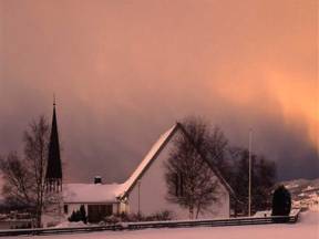
Voll Kirke
Voll Church is located here in Månalen. It was erected in 1896 and restored in 1964. The largest church in Grytten parish looks from the outside like a long church. It was built in the notched timber tradition by the architect G. Smith.
In earlier times there was a church dating from 1674 on the same plot.
As to objects of interest in the church, we can mention a Bible from 1732, an altar from 1648, and the organ of 1840, probably the oldest organ still in use in the country. Previously, the organ was in Mandal church but was moved to Måndalen in 1926.
It was made by the organ builder Albrechtsen from Trondheim and shared a similar fate with many other instruments; it was in a very bad state. Fortunately, it was restored in connection with the church's 100th anniversary.
The Måndal Tunnel
The Måndal Tunnel passes between Måndalen and Sauset. It is a bit over 2 kilometres long and was opened in May 1993. The Innfjord tunnel opened in November 1991 and together these two tunnels cost 225 million kroner.
Måndalstunnelen replaced a section of the road previously endangered by landslides. The old road with its more basic safety precautions may still be used for travel.
The new tunnel's aspect and construction differs a great deal from the older one.
Before, there were rough-hewn mountain walls lining a dark, cavernous throughway. Now you will find a range of modern installations like frost protection, video surveillance, emergency telephones, fire extinguishers and more.
In Måndalstunnelen there is also full coverage for DAB radio and emergency networks throughout the passage.
Vågstrand tunnel
Danger from frequent landslides caused the previous road on E 136 between Rauma and Vestnes to be replaced by the new, almost 4 km long Vågstrand tunnel. When it was opened, a number of school buses had the honor of driving through first in order to emphasize the improvement to safety for commuting schoolchildren.
This section is also part of the main route between South-East Norway and Sunnmøre - the so-called Eksportvegen (Export Road) – another good reason for keeping the road open and safe. The project's cost of NOK 500 million kroner is divided between the Norwegian state and motorists who contribute significantly with tolls.
The old road was built during the Second World War and was in places so narrow that it was not wide enough for a median strip. Motorists experienced the road as unsafe and sometimes fatal when colliding with oncoming traffic at high speed. Now the modern road makes the journey a lot safer.
Emergency spaces every 500 meters allow for even larger vehicles to turn around in the middle of the tunnel if necessary.
Large fans ensure good air quality. In case of an accident blocking the tunnel temporarily, a continuous band of light on the concrete rails is triggered automatically.
Vågstranda Church
Vågstranda Church is located on Vågstranda in Rauma municipality. The church was built in 1870 as a so-called hall church or long church. It is built in traditional notched timber style, which was carved in Trondheim.
The church was initially constructed in Trondheim, then the logs were marked and the building dismantled. The building materials were transported to Vågstranda and then properly set up in its permanent location by the architect and builder G. Olsen from Trondheim.
The church was restored on its one hundredth anniversary 1970.
The church bell was molded on Bolsøya by the local bell molder Christensen. The altarpiece, which dates back to 1870, was painted by Balle Lund from Trondheim.
It was by Royal Decree of October 31, 1868 that permission was given to build Vågstranda church on Straume.
The building was to be a church in the new Vågstranda parish. Prior to 1870, the people from Vågstranda belonged to the Veøy Old Church, on Veøya, in the Romsdalsfjord.
Gjermundnes - Agricultural Museum and School
The agricultural museum at Gjermundnes is located on the premises of the old agricultural school from 1898.
The museum is situated on what can be a natural stop halfway between Ålesund and Åndalsnes. From Gjermundnes you have a great panoramic view over to Molde town located on the other side of Romsdalsfjorden.
The museum is set in a charming landscape with plenty of sunshine on clear days. You will also find a beautiful park here with a fine oak alley from 1758.
The place has a long history and has been an important place for people throughout the ages. Among other things, a field of graves lies here dating from the Iron Age. Records show that even a king - Neskongen Gjermund - lived on the Gjermundnes farm in the Viking age.
The agricultural school or Gjermundnes High School, as it is now called, is located here. It specializes in the study of traditional and modern agricultural practices.
At Gjermundnes, pupils can acquire knowledge on aspects of planting and mechanical processes of farming. The school also offers comprehensive courses in equine science.
Vikebukt
Close to 700 people call the village of Vikebukt their home. Vikebukt borders on the villages of Gjermundnes and Daugstad with a bridge linking it to the municipal center at Helland. The nearest town is Molde which is located on the other side of the fjord.
Ålesund and Åndalsnes are reached within an hour's drive in either direction.
A ferry used to run here connecting Vestnes, Molde and Vikebukt. It has been replaced with the Tresfjord bridge between Vikebukt and Helland. You still have to take a ferry from Vestnes to get to Molde.
The road through Vikebukt is referred to as Eksportvegen and links the Ålesund region with traffic in and out of the county.
People have lived here since the Viking Age. Vestiges (or remnants) from a number of caims exist which you can visit in the area. Archaeologists estimate the graves to originate from the Iron Age or the Viking Age.
In 2004, a Viking woman's grave was discovered near Vike church. The grave contained pearls and gemstones of amber, weaving equipment and other accessories.
The woman who was buried here was named "Husfrua på Vike" (The Housewife of Vike) by the archaeologists.
It is believed that this must have been a woman of higher standing who was given a grave memorial here.