Welcome to Norwegian Scenic Route Ryfylke!
The route expands through various cultural sights alongside the 183 kilometer long national tourist route, through a beautiful landscape, magnificent fjords, and naked mountains.
Among the most famous attractions in Ryfylke are The Lysefjord, the Pulpit Rock, and Kjerag, but along the way you will find other surprising places to explore, landmarks from ancient times, and fantastic places to take a break. Enjoy!
To find more content and listen to free audio guides, download the Guide To Go app.
Norwegian Scenic Route Ryfylke
Points of interest
The prehistoric village Landa Park
In about 800 meters, on the other side of Lysefjord Bridge, a turnoff leads to Landa Park, a prehistoric village.
This popular attraction is situated at Fossanmoen about 3.5 kilometres from the Forsand ferry quay.
At Landa Park, you can see history brought alive in a unique and fascinating way!
At the site where archaeologists have unearthed the foundations of roughly 250 houses, Landa Park has been expertly recreated to show buildings from the Bronze Age and Iron Age.
The Bronze Age House is very dark, except for the fire in the open hearth at its centre.
The largest building at Landa Park is the Banquet Hall.
The original on which this design is based is believed to have been the home of a chieftain or other important family; it was also used for celebrations and gatherings.
Landa Park is a village where history comes alive!
During the summer it is open to the public every day except Mondays.
A key part of the experience are the many guides, who all wear period garments. For exact opening hours, please click on the link.
Visitors, young and old, will enjoy hearing colorful stories and take part in exciting activities.
These include baking and spinning and other daily tasks, practicing archery, riding horses or feeding the village animals.
In addition, you may camp here on the campground, there is delicious food at Kafé Mulen, and a museum shop where you may purchase souvenirs.
In 1999, Lysefjord Bridge received the Beautiful Roads Award from the Norwegian Public Roads Administration.
In Forsand there is accommodation, a café and restaurant, pleasant shops, a horse riding centre, and an annual Crab Festival.
Sightseeing boats and express boats traffic the scenic Lysefjord, with destinations including Songesand, from which the road continues to Årdal.
From the quay at Forsand you can also catch the tourist ferry to Lysebotn, the village at the head of the fjord.
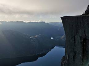
Preikestolen/The Pulpit Rock
A little further up the road is a turnoff to Pulpit Rock (Preikestolen) and Preikestolen Mountain Lodge, a five kilometre detour. Each year, more than 150,000 people visit the top of the famous Pulpit Rock, which rises a sheer 600 metres above the beautiful Lysefjord.
The walk from the parking area to Pulpit Rock and back again takes about four hours – and it is certainly worth your effort! The seven kilometre long trail up to the plateau passes through hilly terrain, slowly ascending 350 metres. Along the path are picnic areas and swimming spots.
We strongly recommend you to bring sturdy footwear, as well as warm clothes and rain gear to allow for changing weather, and a snack to enjoy en route. The best time to hike up to Pulpit Rock is between April and October.
Preikestolen Mountain Lodge is open year round. Please note that you must pay to use the parking area, where facilities include an information kiosk and toilets. From the lodge and parking area, marked mountain trails lead to other destinations.
Warning: Please make sure that you have plenty of time to return from Pulpit Rock before the onset of darkness. It may be difficult to see the trail markers at dusk. Do not start your hike too late in the afternoon, or if there is snow and ice on the trail!
The original lodge near Pulpit Rock was built in 1949, and the road built in 1961. Today’s Preikestolen Mountain Lodge opened in May 2009, with a strikingly modern, award-winning design. The lodge is renowned for excellent dining, and bases its menu on the best local ingredients of the season.
Pulpit Rock is also impressive seen from below, and can be enjoyed by sightseeing boat from Oanes or Stavanger, or from the tourist ferry that runs between Lauvvik, Forsand and other destinations along the Lysefjord.
Rosehagen/The Rose Garden
In Jørpeland, about 1,5 kilometres from the National Tourist Route Ryfylke, you will find Rosehagen, a beautiful garden surrounding an old wooden villa that overlooks the harbour.
At the start of this millennium, Jørpeland steelworks commissioned a number of Norwegian and international artists to make steel sculptures that were placed throughout the village of Jørpeland.
Some of these sculptures can be seen in the park by the villa: “Lyse One” and “Lyse Two” by Richard Heinrich (USA), “Sky Catcher” by Bob Emser (USA), “Veksande metall” (Growing Metal) by Geir Hjetland and “Strandsøyla” (Shore Column) by Ansgar Olsen (both Norwegian).
In the villa is a gallery that exhibits work by well-known Norwegian artists. The sculpture park is always open to the public and the entrance is free.
In Jørpeland you can also see other steel sculptures: “Kongle” (Pinecone) by Leif Gjerme (Norway) stands outside Torghuset; “Mongs Munch” by Richard Heinrich (USA) stands at the crossroads of Rv13 and Rådhusgata; “Metaphor” by Geir Hjetland (Norway) can be seen by Jørpeland church; “King of Trash” by Javier Astorga (Mexico) is placed outside the Town Hall.
Jørpeland has a good assortment of shops, galleries, restaurants and cafés, and a newly opened hotel whose history is intimately tied to the steelworks. There is also other accommodation available in the area.
From Jørpeland you can catch the express boat to Stavanger. During the summer there are also scheduled buses to Preikestolen Mountain Lodge, from which you can walk to the famous Pulpit Rock (Preikestolen).
Petroglyphs
At Solbakk, midway between Jørpeland and Tau between the National Tourist Route Ryfylke and the fjord, there is a field of historically important petroglyphs. Just follow the short, well-marked path to see these ancient rock carvings.
Discovered in 1923, this field of prehistoric petroglyphs comprises nearly 30 portrayals of ships and eight sun figures. The ship figures at Solbakk are most unusual, in that two types of ships are shown, with lines drawn to indicate the crew. The circular sun figures contain smaller sun figures.
These petroglyphs signal that the Bronze Age people had ships and seafaring abilites, but the figures – especially the circular suns – are also believed to have held religious significance.
In a Norwegian context, the ship petroglyphs at Solbakk are unique, as they show both closed and open hulls. There are clearly two boat types portrayed, one with curved bow and stern, while the other and shorter type is shown with straight bow and stern.
From the parking area by the petroglyphs, you can continue on a gravel road along the fjord, driving through a beautiful cultural landscape with stone walls and standing rocks, and passing a nice beach at Kuvika, before rejoining the National Tourist Route Ryfylke.
Røldal
Røldal har i uminnelege tider vore eit viktig trafikknutepunkt. I Håra finn du det nordlege endepunktet for Nasjonal turistveg Ryfylke, der turistvegen, fylkesveg 520, møter E 134. Røldal er vinterstid eit skieldorado grunna mykje snøfall, òg fylkesveg 520 er difor vintersteng oftast til slutten av mai. Då kan ein tilrå å leggja turen til riksveg 13 gjennom Suldal, der ein mellom anna kan oppleva kraftarkitekturen på Nesflaten, det mektige Suldalsvatnet, samt Røynevarden og bygdetunet Kolbeinstveit.
Når du no først er i Røldal, er den vakre stavkyrkja her verdt eit besøk. Røldal stavkyrkje er bygd av tømmer frå dalen, og var ei av dei sentrale kyrkjene på Vestlandet i middelalderen. Stavkyrkja finn du midt i Røldal sentrum.
I høgmiddelalderen var Røldal det viktigaste pilgrimsmålet i landet, etter Nidarosdomen. Røldal stavkyrkje er truleg bygd fyrst på 1200-talet og dekorert innvendig på 1600-talet. Det middelalderske krusifikset over altertavla var tillagt helbredande verknad, og langt inn i protestantisk tid, valfarta sjuke til kyrkja for å bli helbreda.
Kvart år, rundt jonsoktider, blir det framleis arrangert pilgrimsvandring til Røldal stavkyrkje.
Kyrkja er framleis i vanleg bruk som soknekyrkje, og om sommaren er kyrkja open for publikum. Omvising med guide er òg mogleg, men må i så fall avtalast på telefon 53 64 71 16. Informasjon om prisar og opningstider finn du på lenkja "Prisar og
opningstider".
I Røldal sentrum finn du òg sommarope turistkontor, der du kan spørja etter Ryfylkeguiden.
Målandsdalen Reserve
The valley of Målandsdalen contains a temperate deciduous forest that is now a nature reserve. An unusual aspect of this forest is the predominance of old ash trees that have short, thick trunks, topped with an abundance of thin, and much younger branches.
The tops of these trees were traditionally cut off one or two metres above the ground, so that leaves and twigs might be harvested from the abundance of low-lying branches, providing fodder for livestock in the winter.
Målandsdalen Nature Reserve has the only protected woods with traditionally topped trees in Rogaland County. The methods of agriculture have long since changed, and this once distinct feature of the cultural landscape is gradually disappearing elsewhere, as old trees are cut down or die.
From the information board by the parking area, there is a trail through varied terrain and an open, often sunny boulder field.
Målandsdalen Nature Reserve comprises 8 hectares of hillside immediately above the National Tourist Route Ryfylke. Although elm and linden trees were also topped, ash gave the best fodder and was the tree most commonly harvested for its leaves.
The nature reserve has a rich fauna and varied bird life. Species that especially thrive in the old, hollow trees here include the pied flycatcher, spotted flycatcher, and various types of tits and chickadees. Deer regularly pass through the upper part of the woodlands, and moose and roe deer are also seen occasionally.
From Målandsdalen you can see another popular attraction to the south, Mount Reinarknuten, towering above Tysdalsvatnet lake.
Årdal old church
Årdal old church, situated in a beautiful cultural landscape by Årdal village, is well worth a visit.
This small, red wooden church is one of Norway’s most distinct Renaissance-style churches.
The oldest part of the church dates from 1619.
To accommodate the growing local population, master carpenters later removed one wall and enlarged the church.
As a result, Årdal old church received a distinct form and is sometimes referred to as “the church with three roofs”.
The interior is richly decorated with paintings of prophets, angels and floral motifs, and the pulpit and altarpiece, were painted by Godtfred Hendtzschel.
In older times, the class structure of rural Ryfylke was very visible even in church.
The benches at the front, which were richly embellished, were reserved for rich families and clearly labelled with the name of their form.
Common people were shown to the plain unmarked benches at the back of the church.
People who emigrated from Årdal to America later, sent money to build a new church at Årdal.
The white wooden church was completed and consecrated in 1919.
In the summer, Årdal old church is open to visitors. On 29 July there is a special service to mark St. Olaf’s Vigil.
Near the turnoff to Mælsøyrane, by the National Tourist Route Ryfylke, there are a number of ancient grave mounds.
Skulp-turen
Kunstløypa "Det gode liv" ligg utanfor Spa-hotell Velvære på Hjelmeland. Med kunstprosjektet "Det gode liv" har fem anerkjente kunstnarar frå inn- og utland blitt utfordra til å formidla kva dei legg i omgrepet "Det gode liv", gjennom å skape store skulpturar i skiferstein frå Randøy i Hjelmeland.
Skulpturane er plasserte på nedsida av Spa-hotell Velvære, som ligg ved sjøkanten, og på toppen av Hjelmen, åsen som ligg i enden av ei merka tur-løype rett bak hotellet.
Dei som ynskjer det kan leggja turen via eigen promenadesti til Hjelmelandsvågen, før ein vender nasen oppover mot Hjelmen. Kollen har gjeve namnet sitt til Hjelmeland kommune, og toppen ligg på om lag 200 meter over havet.
Kunstprosjektet "Det gode liv" består av fleire steinskulpturar. "Northern Winds", som er laga av Santos Carvalho (Portugal, er plassert på toppen av Hjelmen.
Skulpturane "Meeting by the shore at Hjelmeland" av Armando Martinez (Spania), "Oblivon" av Fernando Martins (Portugal), "Sensuality" av Zico Lucena (Portugal) og "Du nører eld" av Arne Mæland (Noreg), som er plassert rundt hotellet.
Kart med informasjon om skulpturane og plasseringa deira får du på hotellet.
Jøsneset peninsula
The scenic peninsula of Jøsneset is surrounded by three fjords: the Jøsenfjord to the south, the Ombofjord to the west, and Erfjord to the north.
A family-operated smokehouse is situated at Skiftun, 1.5 kilometres from the ferry quay in Nesvik. You can buy award-winning smoked salmon and gravlaks at the factory outlet. Look for the sign near the ferry quay.
Further north on Jøsneset lies the holiday facility Knutsvik. Nearby, you can still see the 18th century building of Ryfylke’s chief magistrate.
The peninsula is known for its numerous good hiking trails. You can enjoy walks to the old dam Fosstemmen, or to the top of Mount Gunlanuten, from which you can see the heartland of Ryfylke, the islands and ocean beyond.
The village of Nesvik is a key communications hub, serviced by regional express boats and the Hjelmeland–Nesvik–Ombo ferry. At Jøsneset there is a café, kiosk and grocery store, as well as a guest harbour and a nice pebble-strewn beach.
From Jøsneset you may be tempted to visit the lush islands to the southwest. The island of Ombo can be explored by car or bicycle. From the quay by the grocery store at Eidssund on Ombo’s western side, ferries and express boats depart for islands that lie farther west. The beautiful Sjernarøyane archipelago is a paradise for bicycling!
At Eidssund there is a shop and nursery. About one kilometre north of the shop are ancient petroglyphs that you really must see! Ombo has an excellent network of trails along the shore, and to the top of Bandåsen and Svikodl.
Jøsenfjorden
Jøsenfjorden, ein fjordarm av Boknafjorden, ligg i Hjelmeland, midt i Ryfylke. Fjorden strekk seg om lag 27 kilometer frå Hjelmeland/Nesvik i vest til ville Førrebotn i aust. Fjella ruvar til vers på begge sider av fjorden, opp til høgder på meir enn 700 meter over havet.
Skomakarnibbå er ein særmerka fjellformasjon på sørsida av fjorden. Nibba kan ein sjå i profil frå riksveg 13 mellom bygda Jøsenfjorden og Vindsvik midtvegs langs fjorden.
Frå Hagalid, om lag 5 kilometer rett opp frå Hjelmelandsvågen sør for Jøsenfjorden, kan ein leggja ut på ein totalt 5-6-timars fottur til Skomakarnibba. Turen har bratte og fuktige parti, og krev godt fottøy, men du blir belønna med spektakulær utsikt. Turen er merka, men ta med turkart.
Som så mange andre plasser langs fjordsidene i Jøsenfjorden, har òg Skomakarnibba fått namn frå ei gammal segn. Segna fortel om ein skomakar som slapp dødsstraff mot å sy eitt par sko medan han sat ute på nibba.
Langs Jøsenfjorden ligg det både livskraftige gardsbruk i drift og forlatne gardar og husmanns-plassar. Viss du svinger av turistvegen, og følgjer skilt mot Jøsenfjorden, kan du òg leggja ut på ein kort fottur på merka sti opp til fjellgardane på Ramsfjell.
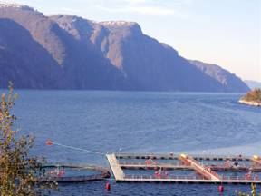
Fisket og sjøfarten på Jøsenfjorden har vore viktig i uminnelege tider. Før kjørevegane på land vart bygde, var fjorden hovudferdselsåra. I dag er det oppdrettsanlegg, for kveite i Kjeurda utanfor Tøtlandsvik, og for laks i Bastlia og Vindsvik. I Vindsvik er det rasteplass.
Lovrafjorden
Om lag 800 meter lenger framme er det eit utsiktspunkt like ved turistvegen, der Statens veg-vesen sitt turistvegprosjekt har fått laga ein kort sti som leiar fram til ei perle av ein rasteplass med flott utsikt over Lovrafjorden, mot Lovraeidet og Lovravatnet. Lovrapunktet, som opna i 2005, vart teikna av det norske arkitektfirmaet Helen & Hard AS.
Lovraeidet er frå forhistoriskt tid eit stort rasområde. Raset skilde Lovrafjorden frå Lovravatnet, der ei spesiell ferskvassflyndre har utvikla seg.
Frå Lovraeidet, inst inne i Lovrafjorden, kan du ta ein avstikkar på om lag 18 kilometer til Jelsa, den best bevarte strandstaden i Ryfylke. Jelsa har mellom anna skulemuseum og ei kyrkje i rennes-sansestil. Frå Jelsa kan du kjøra vidare til Erfjord og turistvegen igjen.
Den første delen av avstikkaren til Jelsa går over Lovraeidet, der vegen skal utbetrast fram til Sandsfjordbrua som skal avløysa ferjesambandet Sand-Ropeid i 2015.
På Jelsa kan ein rusla rundt mellom vakre trehus. Strandstaden var kyrkjestad frå 1200-talet, gjestgjevarhus og handel kom sist på 1600-talet, og frå 1855 kom Jelsa på rutekartet til dampskipstrafikken.
Jelsa kyrkje, som vart ferdigstilt av si tids fremste handverkarar i 1647, har fått tilbake delar av den gamle innvendige utsmykkinga, mellom anna det unike blåmala taket med stjerner, måne og sol på himmelen.
Det gamle skulehuset, som var barneskule for strandsitjarborna på Jelsa fram til 1900-talet, er gjort om til skulemuseum. Skulemuseet og kyrkja er ope for omvising klokka 12-17, sundagar i perioden 21. juni - 17. august 2014. (guiding på sundagar foregår når det ikkje er gudsteneste)
Bergekrossen junction
In a minute or two, you will reach Bergekrossen, which is the junction of highway rv13 and fv46. The latter road takes you to the fjordside village of Sand, where attractions include the Salmon Studio at Sandsfossen falls.
In Sand, we also recommend taking the time to explore the neighbourhoods of old wooden houses before taking the ferry over to Ropeid and fv 520, and continuing the National Tourist Route Ryfylke to Sauda.
At Ropeid there is an eye-catching, glass-walled waiting room designed by architects Jensen & Skodvin and built in 2004.
The road from Sauda across the mountains to Røldal usually is closed in the winter, from the first snowfall in November until the end of May. The alternative route is to take highway rv 13 through Suldal, or head south on the National Tourist Route Ryfylke to Hjelmeland and through the southern parts of the region.
The valley of Suldal offers many attractions. You can, for instance, visit Kolbeinstveit old farmstead and the crofter’s farm at Røynevarden, or stop to admire the architecture of the old hydropower facility at Nesflaten, a complex that now includes a hotel.
Tourism began in the 1880s in scenic Ryfylke, and the so-called Discovery Route as well as The Inland Route have been particularly popular since the very beginning. This journey takes you from the fjordside village of Sand, through the valleys of Suldal and Brattlandsdalen, and across the mountains to Røldal village and the town of Odda. The Tourist Information office at Sand can provide you with more information on The Discovery Route.
A great scenic detour is to explore Ropeidhalvøya, a peninsula on the other side of the Sandsfjord. For wonderful hiking, head for the mountains of Gullingen, where the excellent trail network may be enjoyed during the winter as well as summer. The National Tourist Route Ryfylke continues to Jøsenfjorden, another idyllic fjordside hamlet.
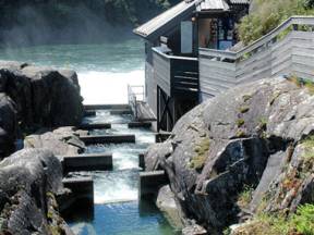
Laksestudioet på Sand
Lakseelva Suldalslågen er 22 kilometer lang, og renn nedover dalføret frå Suldalsvatnet og munnar ut i Sandsfjorden ved Sand sentrum. Sandsfossen, som er den siste delen av lågen, er berre fire meter høg, men likevel svært brei og har ein imponerande fossedur. Fossen ligg eit par minutts gange frå Sand sentrum, tett ved laksestudioet i kanten av fossen.
Laksestudioet er ope frå midten av juni og ut august, samt helger i september, medan fossen kan opplevast heile året. Ein kan òg sjå historiske laksetrappar og andre innreiingar for laksefiske, som framleis ligg rundt fossen. Like ved lakse-studioet er det parkeringsplass og rasteplass.
Sand har òg nokre "lakseaktivitetar" å by på, som til dømes laksesafari og elveekspedisjon hjå Mo Laksegard.
Laksestudioet i Sandsfossen er det første laksestudioet som vart bygd i Noreg. Laks på veg opp laksetrappa kan ein sjå gjennom to store glasvindauge i gytetida, i juli til september
/oktober, men ein kan òg sjå mykje sjøaure tidlegare om sommaren.
Suldalslågen er kjend for stor laks. Det er ikkje uvanleg å få laks på 10 kilo, og årleg blir det fanga laks på bortimot 20 kilo. Den største fisken i nyare tid var ein laks på 21,5 kilo, som vart fanga med fluge i Sandsfossen i 2010.
Engelske aristokratar kom til Suldal på slutten av 1800-talet, og bygde seg "lakseslott" for å feriera og fiska i Suldalslågen.
Vinter 2013 vart det bygd ei gangbru døypt «Høse bru» med tilliggjande tursti ved laksestudioet. Brua er teikna av det anerkjende arkitektbyrået Rintala Eggertsson AS. Ta deg ein rusletur og opplev Høse bru, Sandsfossen og Suldalslågen frå den andre breidda.
Strandstaden Sand
The fjordside village of Sand is the administrative centre of the Municipality of Suldal and is beautifully situated on the Sandsfjord.
Many of the old houses are well preserved, especially in the northern end of the little town, where clusters of white wooden houses line the street. The Tourist Information and Ryfylke Museum’s headquarters are located in Nesasjøhuset, an old wharf building. Here are several interesting exhibitions, including one that children will especially enjoy, the fairytale White Bear King Valemon.
As Suldaslågen river empties into the Sandsfjord, it reaches a crescendo at Sandsfossen falls. By Sand church is an old cemetery; some of the graves date back to the 19th century, when wealthy Englishmen and lords came here on holiday, fishing salmon in the river.
In Sand you will also find a cultural centre, a Salmon Studio where you can peer into the water and see the salmon swimming, an attractive sandy beach, friendly shops, restaurants and cafés. Sand is a hub for travellers in Ryfylke, with a ferry to Ropeid, and express boats and buses serving destinations throughout the region. There is also a guest harbour here.
The popular Ryfylke Days, during which there are fun activities for the entire family, are arranged in June every year. In the autumn the Møgedal Market at Bergekrossen draws visitors from afar.
When you take the ferry between Sand and Ropeid, be sure to find a good place on deck or by the windows so you can enjoy the beautiful view. The quotes posted on board the ferry are from books by Rasmus Løland, a pioneer of Norwegian children’s literature. On the occasion of the 150th anniversary of its celebrated local author, Ryfylke Museum invites the public to the exhibition White Bear King Valemon in Nesasjøhuset cultural centre.
Jonegarden farm
Jonegarden, the farm museum at Hustveit, is situated midway between Ropeid and Sauda, at the end of a one kilometre long gravel side road.
There are actually two farms here. Jonegarden, run by Ryfylke Museum, has been restored to its late 19th century appearance. The barn was moved from Tysseland in 2004, and stands on the foundations of the original old barn.
The furnishings and interiors of the farmhouse are original, providing an authentic impression of a 19th century Norwegian farm.
We recommend a walk to nearby Kvednafossen falls. The trail takes you through a scenic cultural landscape up to a millhouse, grain drier, sawmill and workshop.
The area around the farms at Hustveit is well suited for hiking and recreation. Well-marked paths lead to Hustveitsåta and the mountain farm Stølen. The hike up to the peak, 1187 metres above sea level, is demanding, but the magnificent view is well worth your effort. Stølen, a restored mountain farm situated a couple hours’ walk from Hustveit, has several beds and offers accommodation.
The barn is open all year, and the light turns on automatically when you enter. Inside is an exhibition on the farmstead and the families who once lived here. In the hayloft is another exhibition on stave construction – the same building method that was used in Norway’s famous stave churches.
Åbøbyen
Åbøbyen i Sauda sentrum er eit bustadområde med rundt 120 frittliggjande trehus. Byanlegget er blant dei best bevarte bustadområda for arbeidarar og funksjonærar som ein har frå utbygginga av den kraftkrevjande industrien her i landet.
Det kanadiske selskapet som starta smelteverket i Sauda, bygde husa her til arbeidsstokken sin.
Husa vart reiste over ein periode på 60 år, det første i 1916. Husværa hadde, samanlikna med andre hus, høg standard, med fasilitetar som bad og vassklosett.
Området er prega av bustadstruktur med klasseskilje. Firefamiliehusa for arbeidarane vart bygd først, og ligg nærast fabrikken. Lengst vekke frå fabrikken og røyken, ligg einebustadene for dei høgare funksjonærane. For formenn og lågare funksjonærar vart det bygd tofamiliehus. Eit døme på ein industriarbeidarheim finn du i Industriarbeidar-museet.
Industriarbeidarmuseet er eit firefamiliehus som vart bygd i 1917, og er dermed blandt dei eldste arbeidarbustadene i byanlegget. I første etasje har Ryfylkemuseet innreidd eit husvære frå 1920-talet, og i andre etasje er eit husvære frå 1960-talet. I første etasje finn du òg ei fotoutstilling.
Åbøbyen har leikeplassar, fine parkar og sports-anlegg som tennisbane og heilårs fotballbane.
I kort gangavstand er det turistkontor, koseleg handel, kaféar og hotell.
I Saudahallen finn du Fagerheimsamlinga, over tusen trefigurar laga av Ola Fagerheim, som illustrerer livet i arbeid, helg og høgtid i ei vestlandsbygd kring 1900.
Røldalsvegen
Røldalsvegen, fjellovergangen mellom Sauda i Ryfylke og Røldal i Hardanger, slyngjer seg gjennom eit skiftande og dramatisk landskap opp mot 900 meter over havet. No er du komen til toppen på fjellovergangen som vart bygd med amerikansk kapital kring 1960. Vegen er smal, med mange svingar.
På denne fjellovergangen kan det koma opp til 5-6 meter snø om vinteren, så vegen er som normalt vinterstengt frå det første snøfallet kjem i november til starten av juni. Omkjøring vinterstid blir då på riksveg 13 mellom Sand og Røldal.
I 1914 starta ei storstilt vasskraftutbygging for å forsyna smelteverket i Sauda med elektrisk energi. I samband med Saudautbygginga på 2000-talet vart Svartavatnet oppdemt og regulert, og fallet blir utnytta i Svartkulp kraftverk.
Nærare Sauda finn du det populære hytteområdet Breiborg og den vakre Hellandsbygda.
Like ved turistvegen, nærare Røldal, finn du Gjertrudshidleren. Denne hidleren vart brukt av folk frå Røldal i samband med støling. Det har nemleg vore lang tradisjon med å senda geiter og sauer på beite i området om sommaren. Framleis blir sauer og geiter frakta langvegsfrå til sommarbeitet her.
I Ekkjeskaret ovanfor Røldal spring det ofte nysgjerrige og fotogene geiter, som du kan ta bilete av med Røldalsvatnet i bakgrunnen.