Enjoy this spectacular bus trip to Stegastein! Download the audio guide and press the start button, and enjoy the stories that play automatically when you move within the red areas of the map on your mobile phone.
Have a nice trip!
Audio guides available in:
Deutsch , Français, Español, 日本語, Italiano, 한글 , Norsk bokmål, English (British)
To find more content and listen to free audio guides, download the Guide To Go app.
Bus trip to Stegastein
Points of interest
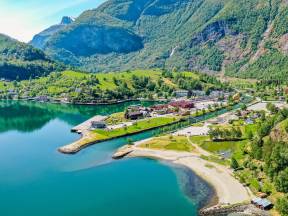
Flåm
Flåm is a well-known village, both nationally and internationally. The tourist village has a long tradition and a proud history, connected to the fjords, mountains, the Flåm river, the Fretheim Hotel and most notably the Flåm railway, which in the last 20-30 years has put Flåm on the map.
Did you think that Flåm would be a bigger? There are many who think that, but actually there are no more than 400 inhabitants living in Flåm itself. Most of them live on a 4 kilometre stretch between the fjord and Flåm Church. Many people choose to walk this stretch when they visit Flåm.
Flåm church was built down by the fjord and was completed in 1668 but blew down the following year! In 1670 the church was rebuilt, but this time further up the valley, where the church still stands today. Flåm Church is made of wood and is still in active use today.
The Flåm river was an important element of early tourism in Flåm. The river was renowned for its good fishing, both salmon and brown trout. The excellent fishing enticed wealthy English tourists, also known as the “salmon Lords” they streamed into Flåm towards the end of the 19th century.
This was considered by many to be the start of tourism in Flåm. The large white building down by the railway line is the historic Fretheim Hotel, which was built early in the 20th century. Since then the hotel has been developed and extended several times, it is open year round. At the back of the hotel you will find the Fretheim culture park, with nice hiking trails and a good view over Flåm and the Aurlandsfjord.
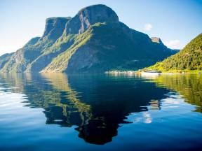
The Fjord
Flåm lies at the end of the Aurlandsfjord. The fjord is around 28 kilometres long and is a side arm of the Sognefjord, which is one of the world's longest fjords. The fjord stretches 200 kilometres from the coast inland. In this area the fjord is between 50 to 100 metres deep, but further out into the fjord it gets deeper and at its deepest is 1300 metres deep.
The water in the Aurlandsfjord is a blend of salt and fresh water, as several large freshwater rivers run out into the fjord. The mountains in the area are high, at their highest point reaching 1800 metres above sea level.
There is not much ice on the fjord in winter, but sometimes ice does form in the innermost part of the Nærøyfjord. During the periods when there is ice, then there will be changes in the boat timetable between Flåm and Gudvangen, as the modern electric vessels cannot sail through ice.
In addition to the Aurlandsfjord which we are now sailing along, you can find the entrance to the Nærøyfjord around 10-12 kms further out into the fjord. In 2005 Nærøyfjord along with Geirangerfjord was listed as a UNESCO world heritage site. There are 7 attractions in Norway on the list. The following year National Geographic Traveller magazine, voted Nærøyfjord and Geirangerfjord as the world’s best managed world heritage sites and in 2009 fjord Norway was voted as the world’s most beautiful travel destination.
Transportation
The Lærdal tunnel between Aurland and Lærdal is 24,5 kms long making it the world’s longest car tunnel. The tunnel was opened in 2000, work on the tunnel took over 5 years.
The tunnel is built in four sections, with three large mountain caves between. These are illuminated with blue lights to break up the monotony of the tunnels for those driving through. The purpose of building this tunnel was to create a winter-safe connection between Norway’s two largest cities Oslo and Bergen.
Since the opening of the Gudvanga tunnel in 1991, transportation has changed considerably for the towns of Gudvangen, Aurland and Flåm. The car ferry that had transported traffic between the towns for many years was now replaced with tunnels. The travel time between East and West was considerably shortened and it was now much easier for tourists to visit these beautiful fjord towns.
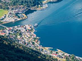
Aurland
The town of Aurland is the main town in the municipality, and it is here that most permanent residents live. Of the 1700 inhabitants in the municipality, around 1100 of them live next to the fjord and in the town centre, in the area called Aurlandsvangen
The large valley road to the East, which is called Aurlandsdalen, stretches around 35 kilometres up the mountain towards Hallingdal. Today, there are thousands of people who hike the Aurlandsdalen, most of them walk from Østerbø down to Vassbygdi, a 6–7-hour hike through beautiful and wild nature.
In connection with the development of hydropower in the mountains between Aurland and Hol, the road over the mountain to Hallingdal opened in 1974. This was an important event for Aurland and the mountain pass is open all year round.
In the centre of Aurland is the Vangen church which was built around 1280. The church is built in stone and history tells us that it took a whole 80 years to build the church. Vangen church has seating for 270 people and is still in active use.
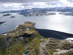
The Fjord and Mountains
Around 1,5 hours away from Flåm you can find the largest glacier in Norway, Jostedalsbreen. The glacier stretches up to 2000 metres above sea level, and in the spring, there can be 10-12 metres of snow up on the glacier. Although, over the course of the last 20-30 years, the glacier has shrunk, mainly due to higher temperatures.
In Vestland there are many fjords and valleys. These were formed during the ice ages. the last ice age ended around 10-12 000 years ago. At that time the whole of Scandinavia was covered in ice, and in this area the ice was around 2000 metres high. When the ice melted the glacier moved, and large rivers ran down to the coast. The rivers carried stones and gravel with them and that was how the valleys and fjords were formed. This happened over the course of many ice ages, probably through 35-40 ice ages.
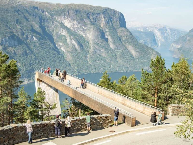
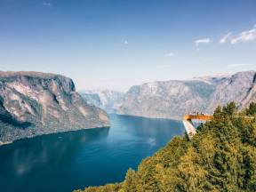
National Tourist Route and the Stegastein View Point
We have now left the centre of Aurland and will drive 8 kms up and over a mountain road to the Stegastein viewpoint, which lies at 650 metres above sea level. This road goes up over Aurlandsfjellet and down to the town of Lærdal. The road opened in 1967 and is in total 40 kms long. The road’s highest point is at 1300 metres above sea level. The road over Aurlandsfjellet is only open in summer but the road up to the Stegastein viewpoint is open all year.
The national tourist routes are a collection of 18 selected stretches of road which pass through landscapes with unique natural qualities, along the coast, fjords, mountains, and waterfalls. One of these routes is the road over Aurlandsfjellet, also known as the snow road. Along this road you can find several installations, one of these is the Stegastein viewpoint which is the goal of this tour.
The viewing platform stretches 30 metres out above the pine tops, and a whole 650 metres out over Aurlandsfjord. The viewpoint was designed by the architects Todd Saunders and Tommie Wilhelmsen who had the desire to lift the visitors out into the landscape enhancing their impression of the Aurlandsfjord. The viewing platform is light, dynamic, and floating, built in glulam and steel with a thick glass plate at the end, which enhances the experience of the powerful landscape. Stegastein viewpoint was completed in 2006 and is open all year round.
The architects wanted the toilet facility to contrast with the floating platform and created a heavy, solid, simple building built directly on the ground. The toilet facility in black concrete and wood is positioned a little above the edge of the “cliff”, so that visitors using the toilet can enjoy the majestic view over the fjord, without anyone being able to look in on them.
The Power Municipality
Aurland has enormous reserves of freshwater spread out over a large mountainous area, and the exploitation of these resources has made Aurland into one of the most prosperous municipalities in Norway. The development of hydro power in Aurland started in the summer of 1969 but at that time Aurland had no road connections.
So, first roads had to be built. 160 kms of construction roads were built through very difficult terrain. Where it was impossible to build the road due to the terrain, they used a method that was completely new at the time - the use of helicopters.
The power development in Aurlandsdalen is made up of a large network of dams, tunnels, and power stations. The same water is used several times when it passes through the various power stations on its way down from the high mountains to the bottom of the fjord. The project was massive in a global context. 37 mountain lakes were included in the development, and 11 dams and 11 stream intakes built. When all five power plants were finished in 1989, they produced a total of 2,6 TWh of electricity. Today, this amounts to 30% of the energy group’s total annual production. Nowadays, the group is the second largest hydro energy producer in Norway, and its yearly production covers the power requirements of around 500,000 households. Most of the energy produced is sent to the capital Oslo.
The natural surroundings have been well taken care of during the building of the power development, and Aurlandsdalen is one of Norway’s most popular hiking routes. It is a narrow valley with steep mountainsides and is renowned for its especially beautiful nature. Each year many visitors and locals take mountain trips in the area.
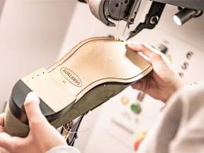
Aurland Shoes
In the centre of Aurland, just a stone’s throw from the church is the Aurland shoe factory. The tradition of shoe making in Aurland has roots stretching back to the 1880s. At its height there were 19 shoe factories in Flåm and Aurland. But today only Aurland shoe factory remains.
The creator of the legendary Aurland shoe was Nils Tveranger. As a 17-year-old he travelled to Boston, USA to learn the shoe making trade. It is claimed that he was inspired by Native American Indian moccasins as well as the Tese shoes of the indigenous Norwegian people. When he came back to Aurland, he started production of a variant of the shoe that he had seen in America, today it is known as the Aurland shoe, or as they like to call them “the original penny loafer”.
The factory is a part of the Canadian organisation “Economusee”, established in Quebec in 1992. “Economusee” is an econo-museum which focuses on conveying the company’s history, showing how the product is made and selling the product whilst preserving the traditional skills and craftmanship.
As of 2022 ‘Economusee’ had a total of 11 Norwegian businesses in their organisation.
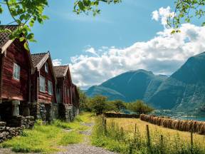
Otternes
You can see Otternes farmyard on the hill, above the road that we are now driving on. Otternes is what is known as a cluster farmyard consisting of 27 houses, dating back to the 18th century. The farm also had a large wooded area and fields attached to it.
There have been permanent settlers at Otternes for over 400 years. In the 1800s there were 30 people living on the farm and right up until the 1970s the farm was run using traditional methods. The last migration from the farm took place in 1996.
The farmyard has therefore has not changed much throughout the years and many of the buildings appear much as they would have done in the 1700s. in addition, the cultural landscape with its, wells, walls and steps are still intact. Today, Otternes is a cultural monument, but at the same time a living farmyard which is open every summer.
It is possible to cycle or walk between Flåm to Otternes, along a popular path stretching around 4 kilometres. You can see the path to the left of where we are now driving.
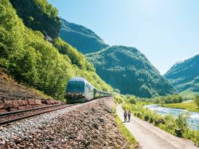
The Flåm Railway
The Flåm railway is the biggest tourist attraction in the area, with trains running all year round.
The railway opened in 1940. The number 20 is especially relevant here, work on the track took 20 years, the track is 20 kms long, and the track runs through 20 tunnels between Flåm and Myrdal.
The track was built to transport people and goods between the Sognefjord and the Bergen line. Today, the journey through the magnificent landscape is a major attraction in Flåm and Aurland. The return journey on the Flåm line takes around two hours.
Thanks for the visit, I hope you enjoyed your ride with us!