Click on the link below and use code 1874. The video is in English.
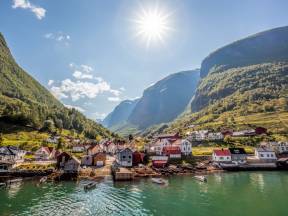
The world’s most beautiful boat trip
Join us on one of the world’s most beautiful boat trips between the idyllic villages of Gudvangen and Flåm on the magnificent Aurlandsfjord and Nærøyfjord.
The latter is one of only two fjords in Norway that are on the UNESCO world heritage list, thanks to their stunning nature which is described as a classic example of the beautiful and very distinctive fjord landscape that is found here in Norway.
In addition to the spectacular nature, where mirror like glaciers and wild waterfalls meet sheltered fjords and troll mountains, the cultural landscape of the area gives an extra dimension with old farms and summer farms literally hanging on the steep mountainsides.
On this boat tour, you can experience all of this directly on your phone through the comprehensive narration, pictures and text as the boat approaches or passes the places of interest along the route.
We at the Fjords are working to do our utmost to deliver you an excellent travel experience. Enjoy the tour!
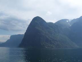
This journey is packed with world class visual experiences, and they begin already, here in Gudvangen the innermost part of the arm of the Nærøyfjord.
As you can see, the village is not very big but is beautifully enclosed by majestic mountains with beautiful, lush valley sides.
The beautiful Nærøydalen runs inward to the village of Stalheim and follows the Nærøydal river with its countless spectacular waterfalls and small streams until it eventually flows out here at Gudvangen.
Do you like Viking stories? You can also take a visit to the Viking Village of «Njardarheimr» and learn how the Vikings lived. Guests can wander around, try their hand at axe throwing or archery, have a taste of authentic Viking food and experience the distinctive odours of tar and bonfires.
The journey between Gudvangen and Flåm is regarded by many as the world’s most beautiful boat ride.
It is doubtful that the motorists who drive the same stretch through the tunnel to Flåm get the same experience, but the journey is nevertheless much faster. At 11.5 Kms long the tunnel is the third longest in Norway and makes the drive between Bergen and Oslo ferry free.
On the opposite side of the hamlet of Bakka you can find part of the old royal postal road which ran along the Nærøyfjord.
It was mostly used in the winter when the fjord was iced over, making it difficult to travel by boat to and from Gudvangen.
After the creation of the Norwegian postal service in 1674, many paths and bridleways were established between different parts of the country.
The local farmers would row the postmen over 50 kilometres from Gudvangen to Lærdal in the summertime, but in the winter, the inner parts of the fjord would freeze to ice.
The post was then transported around 5 kilometres out of the fjord using a new bridle path which ran from Bleiklindi outside of Gudvangen to the Styvi Farm.
The old royal postal road has been cleared and stone walls have been made by hand. It is a beautiful sight and is today a popular tourist attraction.
An interesting fact for you: the postal and cart road from Bakka gained the status of the county’s very first county road in 1928.
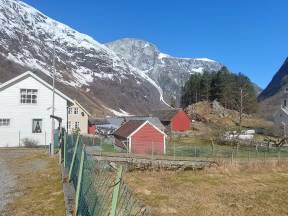
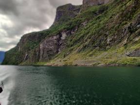
We are now passing by the lush hamlets of Bakka and Tufto.
The fjord is at its narrowest here, just 250 metres wide and the precipitous mountains on either side rise a formidable 1400 metres up into the clouds.
The people who live here have learnt to live from and with the nature, through hunting, foraging and agriculture.
The result is the beautiful landscape that we are now passing, with lush open meadows and farms surrounded by grazing land. In the summer they would traditionally take their livestock and move thousands of metres up to the summer farms.
The pretty little church that you can see, was established by local farmers in 1859 and stands as a bauta and a landmark in the idyllic fjord.
There have probably been people living here since the iron age. Many of the buildings still look like they would have done in the 1800s and are a very popular motif for photographs.
The road that you can see was originally a cart road but was adapted for cars in 1978.
This stretch is extremely prone to landslides of either snow or small rocks, it is therefore often closed, but is nevertheless very important so that the people and cultural landscapes in Bakka and Tufto can be taken care of.
Rimstigen World Heritage Trek
You will no doubt appreciate why Nærøyfjord holds a well-deserved place on the UNESCO world heritage list.
Indeed, the unique combination of nature and culture which UNESCO values so highly, has its own local World Heritage Trek.
The summer farm, Rimstigen, which was established by the farms down here by the fjord, is the starting point for a great hike that will literally take most people’s breath away, whether that’s down to fitness or the view!
From the base here next to the hamlet of Tufto, you can follow the old farm track up to the summer farm at Rimstigen and from there further up to the 1300 metre high Rimstigfjellet and all the way up to the Breiskrednosi cliff, you can see the cliff which lies at 1189 metres above sea level with its steep drop down to the Nærøyfjorden.
Now we are talking about first class views.
Every year on the first Saturday in August, this destination is the starting point for a special arrangement.
The World Heritage Trek. It attracts around 100 participants and ends in Dyrdal.
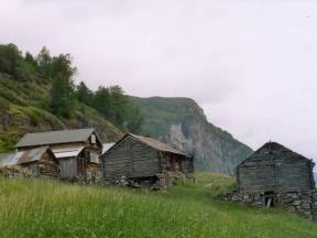
We are soon arriving at the small hamlet or farm, Styvi.
The small green grassy plateau between the sheltered fjord and the steep mountains houses beautiful experiences and a very special history.
People have lived here for almost 1000 years, albeit with some gaps.
There were midwives and teachers here and the postal farmers stopped here on their journey between Bergen and Oslo.
As with most places in Norway without infrastructure, this farm was also characterised by emigration.
But a few decades ago, a family moved here against that tide.
The industrialist Botolv Holv, decided to live permanently here at Styvi where his wife Kjellaug had grown up.
Eventually, he established a café and a farm museum and welcomes thousands of visitors over the summer season.
Botolv was rewarded with the King’s silver medal for merit and his story reached all corners of the country when NRK produced an episode here of the TV show «places that no one would believe you could live».
You can watch the episode by clicking on the link below:
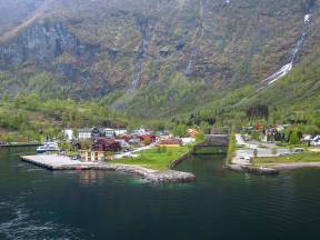
We are mooring soon in Dyrdal, where there will be a short stop.
At one point in time, there were 100 people living in this idyllic green oasis in Nærøyfjorden.
Hengedalen, which continues further over the valley, has scattered but unfortunately disused farms.
Here as in many other places, most of the farms and properties have now been converted to holiday homes and rentals.
Right up until the middle of the 19th century, there was a lot of activity down on the quay, and the village held the status of being the legal centre for Nærøy.
Besides several court houses, there were also cosy guesthouses, some shops and a hospital with 8 beds….yes that’s right a hospital!
Today, most of the activity takes place during the summer, when the holiday homeowners and tourists arrive, and the whole valley awakens from hibernation.
Dyrdal is today used by enthusiastic hikers, some enjoy visiting the distinctive cluster farm down on the quay, whilst others take the cultural historical walk up to the Drægo summer farm, where they offer overnight accommodation and delicious locally produced food.
As with Syvi Farm on the other side of the fjord, the last year-round resident of Dyrdal, Arild Dyrdal also had a visit from NRK and an episode of «places that no one would believe you could live» made about him.
It is not difficult to understand why people are blinded by the magnificent and beautiful nature that they meet here in the fjord. However, something happens when darkness descends or when a thick mist comes down like an impenetrable blanket between the valley sides.
For it is then that the huldre people awake.
In the daytime they live under the ground, but as darkness approaches, they move up towards the surface as a warning, to the horror of the residents.
In the hamlets in these fjords there are many stories associated with both Christmas and wedding celebrations where the huldre people created mayhem for the residents.
We are probably used to the fact that the darkness can conjure, huldre, trolls, sea serpents or nisse, but in 1972 something completely new was observed.
A periscope was spotted in the Sognefjord, when it was confirmed that the military had no boats in the area, the alarm was raised.
Suddenly all the villages along the fjord were thrown into the world’s spotlight and both the press and the public trawled the fjord for a trace of the mysterious submarine.
It is still not known, if it was indeed a submarine or not. Maybe it was the huldre people making fun of humans, or some driftwood floating over the fjord…what do you think?
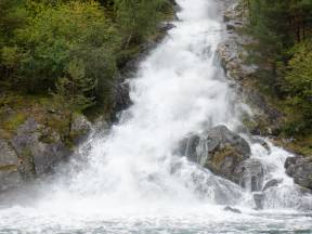
We are now passing the wild Lægda waterfall, or sag waterfall as it is also known.
It falls from around 600 metres from the plateau above the fjord and runs out to sea.
As you can probably understand, this waterfall is only accessible by boat unless you are hiking on the other side of the fjord.
In many ways Norwegian tourism originated in these fjords in the middle of the 19th century.
The English privileged upper classes, and Lords, were fascinated by the Norwegian fjord landscape, where they could catch large salmon in the thundering rivers or hunt the lively deer that grazed on the far-reaching plains.
They sailed into the fjords in their yachts and laid anchor up in the arms of the fjord.
There they would stay for weeks, year after year living a luxury life a world away from what the farmers of Vestland were accustomed to.
Nevertheless, their arrival meant money to the farmers and that is how entrepreneurship around the tourist industry grew.
The yachts would stop right where we are now, and they too were dazzled by the magical beauty of the waterfalls.
It is not every day that you can say that you have a foot in three of the world’s most famous and spectacular fjords at the same time.
But at this moment you do, even if your legs are firmly planted on the deck of the «Future of the Fjords», as we are now rounding Beitelen where Sognefjord, Aurlandsfjord and Nærøyfjord meet.
The fjords of Norway were formed from the first ice age up until around 6500 years ago.
The advancing ice made its way down the landscape under sea level which created the characteristic U-shaped valleys, and when the ice retreated, the sea came in over the land and filled the valleys creating the fjords.
The long Norwegian coastline has many of the world’s longest fjords.
They stand out by being particularly dramatic with steep mountainsides and waterfalls that run straight into the fjords.
Maybe you like fishing? Amateur fishing is an important part of the allemannsretten (right to public access law) in Norway, and you can fish in both the fjords and the sea without special permission – for free!
We wish all of you who want to try your hand at fishing «skitt fiske».
Which literally means ‘dirty fishing’ it is a superstitious expression, wishing good luck without actually saying the words, for fear that it will result in the opposite - bad fishing.
It is easy to be dazzled by what you see in these beautiful surroundings, and in the sea, amongst the rocks and in the mountains, lurks an exciting animal life.
On the rocks on a good day, you can observe dozing seals, or harbour seals sunning themselves. Now and then pods of porpoises pop up, but the best of all is when killer whales come to play in the fjord.
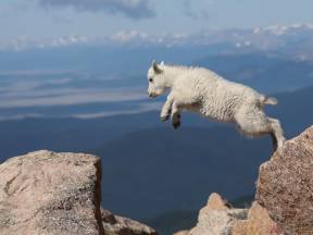
Goats jump and hop on the mountainsides, sheep baa and the cows moo to each other across the lush farms.
But you can also find wild animals such as deer, elk, and reindeer on both the slopes and the mountains, throughout time they have been an important food source for the fjord dwellers.
Today the hunting of these animals is regulated, and the meat is often sold as locally sourced produce at farms, shops, and restaurants in the fjord.
Salmon swim happy and contented in many of the rivers along the fjord, and high up you can occasionally see the majestic golden eagle or sea eagles, with their impressive wingspans hovering vigilantly around.
Do you imagine waking up in a soft fjord breeze, watching the sun climbing over the steep mountainside with the sound of a burbling river and bird song in the background?
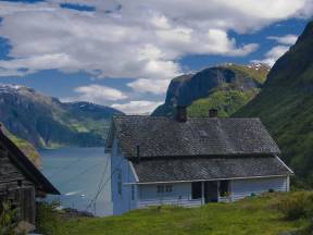
Then you are not alone. In 1992, Stigen Farm which lies some 360 metres up on the mountainside here, was bought by an American – Dee Cunningham.
He and his wife restored the buildings and turned this cultural historical treasure into a tourist gem for those who want that little bit extra.
There have been people here on this small, lush mountain ledge since the Middle Ages, and today Stigen is a popular jumping off point for the fjords and provides overnight accommodation.
Guests can learn about the exciting cultural history and wake up to a priceless view of the award-winning world heritage of the spectacular fjord landscape that reveals itself every morning.
In 2013, Stigen was converted into a concert area, when the famous Norwegian band Vamp held their world heritage concert. You can watch the concert via the link below:
We are now approaching Nedbergo Farm.
People have been living there for almost 1000 years, on the small sun-drenched ledge at almost 550 metres above sea level. They cultivated the land and kept livestock on pastures, and in the summer, they would move it all further up the mountain to their summer farm.
If you take a hike up you will find that the path is both twisty and steep, but after an hour and a half you will find yourself at the top from where you can enjoy the amazing panoramic view over the world heritage fjord.
In times gone by, there were also angry, hungry brown bears lurking around these tracks.
Once the people of Nedbergo had to quickly escape into the house when a bear unexpectantly came for an evening visit, but they didn’t have time to secure their livestock and horse.
The newly shod horse and the bear got into a big fight and the family were certain that their horse was lost.
But to their surprise, when they looked out of the window the next morning, they saw the bear lying there dead and beaten.
The horse was wearing winter shoes and the sharp studs had ripped the bear to pieces.
On the other side of the fjord, you can see Stokko.
Life on the Mountain Farms
Today, we consider the mountain farms as romantic places, where life was exciting, but at the same time the daily life was full of challenges. The approach to the farms was characterised with steep and uneven paths, and the daily chores that needed completing, either on the farm or on the higher summer farms, required the whole family to work hard seven days a week.
It was only the smallest children who didn’t work, and they had to be secured with strong ropes to ensure that they did not fall off the precipitous cliffs. However, in the village book there are nevertheless accounts of people who fell off the cliff edge onto the shore below.
But the worst must have been trying to leave the farm in the winter months when parts of the path were impassable. Should someone die during the winter months, then they would have to wait until the Priest was able to make the journey in the springtime. But on the other hand, if it were the Sheriff or tax collector who were rowing across the fjord, then some farmers would put extra obstacles in the way.
At the beginning of the 20th century, some of the farms began to construct zip lines which they could use to transport both goods and food up and down. It was demanding work, but after it was finished, they saved a lot of energy on the transportation of goods. Whether the zip line of the time transported tourists is questionable, but some people did take a trip down the steep mountainside.
Gygra and the Gleta Stone
There was once an angry, bitter witch who lived in Skjerdal, to the East of Aurlandsvangen.
She had a good view over the beautiful village of Undredal on the other side, but she became increasingly irritated about what the villagers were doing.
When they started constructing the stave church, Gyra, the witch had had enough.
She threw a rope across the land and attached it to Flenes, she began to pull the headland towards her to obstruct the view.
But it was hard work, eventually the rope gave way and she fell down the mountainside, leaving a large hole in the rock, that is today called Gygrasete.
She became irate and took the biggest stone that she could find and threw it at the Stave Church, but she was dizzy after the fall, and luckily missed the church.
Instead, it landed with a huge crash in the place that we are now passing, and divided in two, it remains here today and is known as the Gleta stone.
It is a long time since Gygra has shown herself, but it is said that if the clouds are hanging low over the fjord, then the witch is cooking porridge.
You have undoubtably seen the small white woolly dots balancing along the mountain sides and staring at you curiously if you approach them. Goat keeping both was and still is an important part of the livelihood for the farmers in these beautiful fjords. We are now passing the place where the young goats are kept, the young goats are called ‘kje’ or ‘geitekillinger.’
‘Kje’ is to goat what lamb is to sheep, and the meat is therefore tender and tasty without having too strong a taste. In times gone by, kje meat was often thrown away, but today it is gaining popularity as a great food tradition. And rightly so, because it tastes fantastic.
The young goats are extremely curious and if a boat comes into shore, then they will try to find a way to jump on board. It has happened many times!
The relatively untouched landscape, cultural traditions, and the still traditional running of the farms with amongst other things their goats keeping, was an important reason for adding Nærøyfjorden to the UNESCO world heritage list. Did you also know that goat adorns the shield of Aurland?
Perhaps you can now be tempted by a glass of goat milk? It is in fact the most drunk milk around the world.
Welcome to the world-renowned cheese village of Undredal.
Here, fjords, rivers, mountains, around 50 permanent residents and 357 goats meet on a small piece of land where the houses stand side by side, in what is also known as a house cluster.
And right in the middle of this cluster stands the beautiful and charming Underdal Stave church, testament to a story that goes back thousands of years.
Previously, the people were able to make a living on what nature could provide and the fjord was both a food basket and a trading route.
Goods were refined and delicacies arose.
The goats roaming in the area, provided the raw ingredients for both white and brown cheese, which are still produced here in the village.
The village has always been remote and didn’t have a road connection until as late as 1988! Before that it was only possible to arrive here by boat.
Today, tourists are drawn to the village by the warm atmosphere that hangs over the village in addition to all the nature experiences.
But it is the cheeses that are the high point.
There are several dairies producing cheese in the same way as it has been produced for hundreds of years.
The cheese can be tasted and bought, via tours, or at the eating places or stores that you can find down by the fjord.
There is also a cheese museum which gives you a greater insight into both the local history and the cheese’s journey from the goat to the dinner plate.
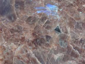
Do you know what the moon and Gudvangen have in common?
They are both one of the few places where you can find the valuable and distinctive, almost magical rock, Anorthosite.
You can see it now in the piles of chalk white stone or sand that can be found at the head of the fjord at Gudvangen. It is mined here and is mainly used in the production of house insulation and to lighten asphalt pavements. The special refraction of light that occurs in the rock, also makes it popular as an ornamental stone or as a coating for countertops.
The Anorthosite that is found here in the massive mountain plateaus between Gudvangen and Mjølfjell has thrilled, left people in wonder, and inspired creative expression.
Amund Helland gave this description of the area in 1901.
“Steep and high mountains border this narrow valley, where on both sides there are large cliffs and screes of labradorite, the colour of which gives the mountains and screes their light colour, so much so that in some places you could think that they are chalk mountains.”
At Mjølfjell on the Bergansbanen railway line, the light, flour coloured bedrock gave association to the nynorsk word «mjøl», which means flour, hence how the name Mjølfjell came about.
But our eyes can deceive us. The rock is not actually chalk white, but more of a blue, grey, or occasionally brownish colour. The special light refraction gives a magical light show depending on how the light is reflected from the moon or the sun.
Soon you will be able to see a road on the steep mountainside.
Construction of the road began in 1954, but it was never finished.
The planners had good intentions that finally the villages of Flåm, Undredal and Gudvangen would have a permanent road connection, and that this stretch of road would become a part of the intended road between Oslo and Bergen.
But as you can see, the hilly terrain and the massive vertical rock faces are not conducive to road building.
Nevertheless, work teams set to work with hand tools and put in place several good solid road foundations that you can see.
They managed to build 600 metres of road, before a tragic accident put a stop to the work.
Later, but not until 1988, Undredal did get a permanent road with tunnels connecting it to Flåm and Gudvangen.
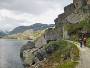
Are you ready for an adventure? The Norwegian fjords are the perfect base for many activities that get the heart beating faster. You can find something for every taste regardless of physical form, and if you want to get moving the small villages and high peaks offer experiences that you won’t forget.
Or maybe the fjord can tempt you with a small paddle tour, or you could whizz over the waves on an inflatable speed boat.
Many of the small fjord roads are sheltered, comfortable cycle paths whilst the valley sides are excellent mountain biking terrain.
Maybe you are interested in taking a gondola tour in beautiful Voss or trying the Nordic’s longest zipline in Flåm where you can whizz across at 100kmh.
And if that is not enough, there are also possibilities for rafting, parachuting, rock climbing and diving in many places.
After such intense experiences it can be good to wind down and get rid of the adrenalin and sweat, and what could be better than a little dip in the fjord before relaxing at one of the steaming saunas that can be found just outside the centre of Flåm.
The possibilities are endless. Check out the link below for information on some of these experiences:
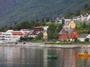
We are now arriving in Aurlandsvangen, the gateway to Norway’s Grand Canyon - Aurlandsdalen. Here the experiences start as soon as you set foot on land and the power of the nature hits you.
From here you can visit Norway’s longest tunnel or the world’s longest fjord, high peaks, lush valleys, and glistening glaciers.
Most people who come ashore here, also take a walk up to the Stegastein viewpoint, well over 400 metres above sea level, where you will be left speechless by the spectacular view that reveals itself in front of you.
This is also the start of the old Aurland road, which is today a national tourist road and is popularly called ‘Snøveien’ or snow road.
Now it is only open in the summer months, although that was also the case even before the Lærdal tunnel was opened in 2000. The trip takes just over an hour and passes through a magically beautiful landscape where waterfalls, snow-capped peaks and vast plateaus await you.
In the village you can also visit the Aurland shoe factory and Économusée, where you can see the shoemakers at work and learn about the famous Aurland shoes.
If you want to learn more about the local history and experience the running of a farm up close, we recommend a guided tour to Skalde Farm which lies high up the open valley side.
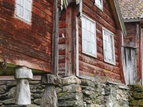
If you look over the road, we are now passing Otternes bygdetun, which is a leading example of how clusters of houses, agricultural and cultural landscapes were formed in the fjord area of Vestlandet in times gone by.
Today, Otternes is a part of the open fjord landscape, and as such was an important reason why the Western Norwegian fjord landscape was entered onto UNESCO’s World Heritage List.
Otternes has traces of a settlement dating from the older iron age from the year 300.
Whilst the oldest houses date back to around 1700.
Such a farm was like a small village and during the 18th century around 30 people lived in Otternes.
The reason that the houses and the cultural landscape are unusually well preserved, is that two of the farms were run in the traditional way right up until the 1970s.
Therefore, the cultural landscape with inland areas, wells, stone walls, ground fences and roads were kept intact.
Today, the 27 historic buildings on the cluster yard are run by a foundation and are open to the public.
There are few places where ancient history and state of the art tourism meet like they do here in this deep fjord arm of the world’s longest fjord.
The Vikings were not only enchanted by the magnificent scenery when they settled here, they also found rich food sources and transport veins to the whole world.
Later people settled here and then the first tourists arrived.
The English Lords sailed into the fjord on the hunt for adventure, good fishing spots and shelter.
Which they found at Christian Fretheim’s Farm, the local food and the service were so good there that word soon spread.
Thus, the Fretheim Hotel that still thrives today was born, based on the best of Sognefjord culture, food, and experiences from the innermost deepest fjord in Sogn.
Ægir brewery have also taken the local culture further.
The brewing of beer in Norway is an old tradition and the Viking’s mead is world renowned.
Ægir therefore opened a pub connected to the brewery, in the style of a Viking longhouse, with a fantastic guildhall in the style of a stave church, open fireplace, and dragon carvings.
To experience the same atmosphere you find here, you would have to travel back at least 1000 years.
Whether you disembark the boat in Flåm or elsewhere, you will undoubtably meet the best of Norwegian national and local traditions.
Welcome to the beautiful and idyllic tourist village of Flåm!
Whether you are arriving or departing from here it is guaranteed to be the start of an adventure that you will never forget.
The little village of just a few hundred inhabitants is visited every year by over a million tourists.
And it is not difficult to see why. Here the experiences are queuing up for you to see, taste or try, whether here in the village or on the road to your destination.
Right now, you are experiencing a vibrant sensory orchestra as you take in the beauty of Flåm.
The village is surrounded by steep lush mountainsides, with the Flåm river running out into the fjord and cutting the village into two.
It is likely that you can see other tourists either on a cruise ship, a kayak, whizzing over the fjord on a zipline or waiting on the platform at Flåm station for a trip on the world’s most spectacular train journey the Flåmsbanen.
If you haven’t taken your camera out yet, then you should consider getting it out now, but you might not need it, because the sights that you see now will store themselves in your memory forever, whether you are disembarking in Flåm or if you are continuing further on the UNESCO world heritage listed fjord.
The Nærøyfjord, introduction
Join us on one of the world’s most beautiful boat trips between the idyllic villages of Gudvangen and Flåm on the magnificent Aurlandsfjord and Nærøyfjord.
The latter is one of only two fjords in Norway that are on the UNESCO world heritage list, thanks to their stunning nature which is described as a classic example of the beautiful and very distinctive fjord landscape that is found here in Norway.
In addition to the spectacular nature, where mirror like glaciers and wild waterfalls meet sheltered fjords and troll mountains, the cultural landscape of the area gives an extra dimension with old farms and summer farms literally hanging on the steep mountainsides.
On this boat tour, you can experience all of this directly on your phone through the comprehensive narration, pictures and text as the boat approaches or passes the places of interest along the route.
We at the Fjords are working to do our utmost to deliver you an excellent travel experience. Enjoy the tour!