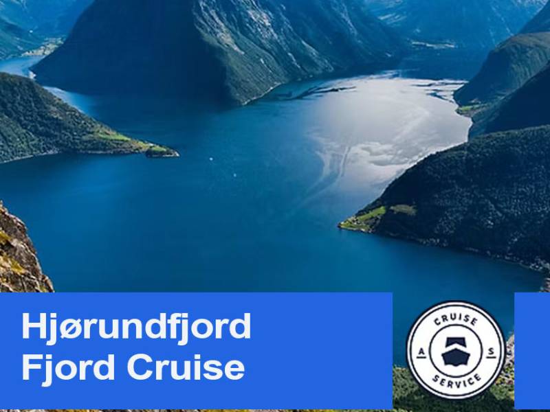
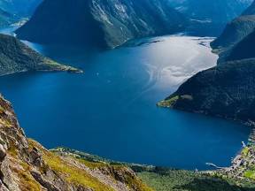
Here at Lekneset, two fjords meet—Hjørundfjorden and its arm, Norangsfjorden—creating a dramatic and beautiful landscape surrounded by the mighty Sunnmøre Alps.
The 35-kilometer-long Hjørundfjorden ends at the small village of Bjørke, nestled deep in the fjord. Norangsfjorden, on the other hand, is short and narrow, only a few kilometers long, but it leads inland to the village of Øye, where towering mountains rise steeply on both sides.
From Lekneset, there is a ferry connection to Sæbø on the other side of the fjord. You can also follow the road along the fjord to Urke and Øye, and further over the mountains to Hellesylt or Stranda—a spectacular drive through Norangsdalen, one of Norway’s most dramatic valleys.
Looking out over the fjord from here, you’ll understand why many say this is among the most beautiful scenery Norway has to offer—where drama, tranquility, and grandeur all come together in a single view.
Welcome aboard!
You're about to experience one of Norway’s most breathtaking fjord journeys, from the vibrant town of Ålesund, through narrow straits and wide fjords, all the way to the charming village of Øye at the end of the majestic Hjørundfjord.
As we cruise through Borgundfjorden and glide past coastal islands, you’ll hear stories of Viking battles, dramatic shipwrecks, and local legends. We'll pass through the slender Vegsundet strait before entering the vast Storfjorden, framed by towering peaks and deep blue waters. Then we turn into Hjørundfjorden — a hidden gem surrounded by the wild Sunnmøre Alps, where steep mountains plunge straight into the sea.
So sit back, relax, and let the landscapes and stories unfold as we guide you on this unforgettable voyage through the heart of Norway’s fjord country.
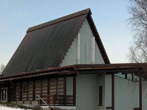
Now we approach Trandal, a small village with no road access but an undeniable charm. Nestled in the heart of Hjørundfjorden, you’ll find Christian Gaard Bygdetun—a hidden gem that uniquely blends history, nature, and hospitality.
What began as a small farmstead with goats, chickens, and cows has evolved into a gathering place for both locals and visitors. Its founder, Frank Storeide, was known for his creativity and out-of-the-box thinking, leaving a lasting mark on the place. Today, the farm is run by his family, who carry on the legacy with warmth and enthusiasm.
Christian Gaard is not only famous for its rustic charm and breathtaking views but also for its music festivals—TrandalBlues, TrandalRock, and Trandal Countryfestival. These events draw music lovers from across the country, offering an experience unlike any other.
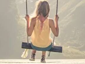
To get here, you’ll need to take a boat—adding to the sense of arriving somewhere truly special. Once ashore, you can enjoy local food, stay in cozy cabins, and perhaps take a swing in the iconic fjord-side rope swing.
Trandal and Christian Gaard Bygdetun offer an experience where nature, culture, and community come together—a place where time stands still, and memories last a lifetime.
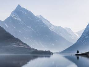
Now we’ve reached the outer stretch of Hjørundfjorden, where the fjord opens into a vast, dramatic seascape. If you look closely, you might spot the ferry crossing between Festøya and Hundeidvik—a vital link connecting the southern communities of Volda and Ørsta with Stranda and Sykkylven to the north. This route is a lifeline for both locals and travelers alike.
Around you, the Sunnmøre Alps rise sharply, their jagged peaks cutting into the sky. Further inland, the fjord narrows, squeezed between steep spires and lush valley slopes. Stretching over 30 kilometers, Hjørundfjorden carves its way through some of Norway’s wildest and most breathtaking mountain terrain—a landscape shaped by glaciers, storms, and centuries of human resilience.
This outermost part of the fjord acts as a gateway—where the open waters meet the sheltered, narrow arms leading to hidden gems like Øye and Bjørke. Here, the wind and waves have room to play, offering a taste of the contrasts ahead: rough and tranquil, towering and intimate. It’s a preview of the visual feast crafted by both nature and the steadfast people of Sunnmøre over thousands of years.
Stand here awhile, and you’ll feel the fjord’s pulse—the meeting point of raw power and quiet beauty.
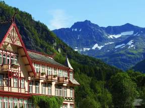
At the very end of Norangsfjorden, cradled by sheer mountain walls and shimmering waters, lies the tiny village of Øye—a hidden gem in the heart of the Sunnmøre Alps.
Here, you’ll find the legendary Hotel Union Øye, one of Norway’s most storied hotels. Since 1891, it has welcomed adventurous mountaineers, royalty, writers, and artists. Stepping through its doors feels like entering another era. The rooms are named after famous guests like King Oscar II and Kaiser Wilhelm II, and the interiors whisper of a bygone age—with deep armchairs, ticking grandfather clocks, and crackling fireplaces.
But Øye is more than a destination; it’s an experience. From the village, you can hike to the towering peak of Slogen, or lose yourself in the haunting tale of Lyngevannet—a lake that swallowed an entire farm during a landslide in 1908. The silence here is profound, broken only by distant waterfalls and wind whistling through the peaks.
Can you feel the magic yet?
Can you spot the kids and goats?
Now we’re passing Ytre-Standal, a small, charming fjord village clinging to the mountainside where the fjord is at its wildest and most beautiful. Though few permanent residents remain today, the landscape and those who live here make it extraordinary. Once a hub with a school, shop, and active farms, it now whispers of quieter times.
The village hosts a renowned fish hatchery, producing high-quality smolt that fuel Norway’s salmon industry—nurtured by the fjord’s pristine waters.
Rent a modern cabin by the shore (boat included!), and wake up to a fjord so still it mirrors the towering peaks—a perfect selfie backdrop.
Nearby, a lively farmyard bursts with goat kids (the playful babies!) and their adult companions, delighting visitors of all ages. This is life at its simplest: close to nature, animals, and tranquility.
Fun fact: In Norwegian, "kje" is a kid (baby goat), while "geit" is adult goat. Now you’ll know what to call those adorable little spring-leapers!
Hjørundfjord is steeped in troll legends, and right now, we’re sailing between the villages of Standal and Trandal. Look north toward the Trandal side—do you see the imprint of the legendary Troll-Wizard (Trollgjøttemannen) in the mountainside?
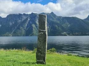
The story goes that Olaf the Holy shot a 4-meter stone arrow straight through the troll, piercing the mountain before ricocheting back across the fjord. That arrow still stands today as a monolith (bauta) near Store Standal.
And the troll? Its face is forever etched into the rock—nose, scowling brow, and all. What became of it? No one’s seen it since… but locals swear that when storms roll in, smoke curls up from the shore or gunshot-like cracks echo off the cliffs. Some say it’s the troll’s restless spirit—or proof it’s still lurking.
So—do you believe?
Now the fjord opens up towards Sæbø, the largest village in Hjørundfjorden and a natural hub for trade, education, daily life, and transportation. Here, fjord and mountains meet at their most magnificent, with Skårasalen, Saksa, and Slogen forming a dramatic backdrop.
For hundreds of years, Sæbø has been the center of the fjord communities. It was once a trading post, mail stop, and steamship dock, and even today, it still has a grocery store, school, gas station, and ferry terminal. Ferries run to Urke and Lekneset, and Sæbø remains a vital link between the many villages around the fjord.
In summer, the place fills with boat tourists, mountain hikers, and travelers passing through. But for the locals, it's everyday life that matters—schoolchildren at the dock, cows grazing on the slopes, fishermen hauling traps and nets, and community gatherings at the village hall.
Along the shoreline, there’s a small swimming beach and several places to stay, and you can rent both boats and bicycles. Many use Sæbø as a base for mountain hikes—with marked trails leading straight from the village to some of the Sunnmøre Alps' most stunning peaks.
Between the island of Humla and the mainland stretch the narrow, calm waters of Kavlesundet and Humlesundet. Here we pass through an area where nature and industry exist side by side. On Humla, you’ll see forested hills, scattered houses, and the old fuel depot, which is still in operation. Across the water lies Fiskarstrand, known for both shipbuilding and seafood production. Here you'll find Fiskarstrand Verft, one of the oldest shipyards in the region, and Tranvåg – a modern fish processing plant that refines and exports seafood to markets around the world.
The strait is also known for its rich birdlife and peaceful waters when the wind settles – a quiet gem between industry and nature, where you can truly feel a sense of calm. You might hear seagulls calling overhead or spot a fish breaking the surface. This is a glimpse of authentic coastal life, still thriving today.
To the northwest, we now pass Urke and the small village of Maude, while the Stenes farm barely peeks out on the other side of the fjord. Here, in the heart of the Sunnmøre Alps, the villages cling closely to both the fjord and the steep, barren mountains.
Urke is one of those small villages with a strong sense of community. A few dozen residents keep the place alive, and here we find what may be Norway’s most charming shop—Urke Landhandel. The store was saved from closure by local enthusiasts and now serves as a shop, meeting place, and historical museum. Here, you can buy everything from locally cured meats to homemade juice—and maybe a good story as a bonus.
The fjord has always been both a source of food and a travel route, and the rugged mountains likewise. The steep slopes are difficult to traverse but provide both grazing land and shelter. In the summer, the mountain pastures fill with sheep and the bustle of farm life. In autumn and winter, however, the polar night, storms, ice, and meters of snow could be demanding for both man and beast.
Can you imagine living here year-round, experiencing the contrasts between romantic, warm sunsets and calm seas, and icy storms with roaring rivers and waterfalls?
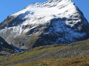
Now, rising above you like a majestic pyramid, is Slogen – perhaps the most iconic peak among the Sunnmøre Alps. It towers 1,564 meters straight up from the fjord, steep, elegant, and awe-inspiring. Many refer to Slogen as the queen of these dramatic mountain summits.
Climbers and adventurers have been drawn here since the 19th century. The British mountaineer William Cecil Slingsby was among the first to reach the summit in 1870, and he famously called the view “the finest in Europe.” That says a lot.
Hidden behind Slogen, in a quiet mountain valley, lies Patchellhytta – a mountain cabin built in 1921 by the Sunnmøre Hiking Association. It's named after Charles Watson Patchell, an English mountain enthusiast who spent many summers exploring these peaks. The cabin is still a popular base for hikes to Slogen, Jakta, and Smørskredtindane.
You can’t see the cabin from the fjord, but you can feel the landscape it belongs to – powerful, serene, and unforgettable. And perhaps now you understand why this area continues to enchant hikers and nature lovers from all over the world.
We now see Mauseidvåg at the innermost point of the bay – a small settlement where people have lived close to the sea for generations. The area has deep roots in farming, fishing, and small-scale industry. In earlier times, this was a natural hub for boat traffic, with a dock, local shop, and the mail boat connecting nearby communities.
Today, many residents commute to work in Ålesund or Langevåg, but there’s still life in local workshops and small businesses. The calm bay, the small harbor, and the surrounding landscape tell the story of a place where tradition and modern life continue side by side.
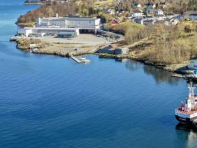
We are now approaching Veibust, a key commercial and industrial area in Sula Municipality, located just at the border with Ålesund. This modern and diverse business district has grown steadily over the past decades and now includes everything from car dealerships and construction suppliers to logistics companies, production facilities, and skilled trades.
Veibust is strategically located with excellent road connections to Ålesund city centre, Langevåg, and the E39 highway heading south. The area has become an important hub for business and transport in the region. Many small and medium-sized enterprises have set up operations here, making Veibust a place where city and countryside, commerce and craftsmanship, all come together in the heart of Sunnmøre.
Now we’ve arrived at Store-Standal, a place steeped in a long and dramatic history of survival and endurance. Above you looms Storhornet, and the snowfield clinging to the mountainside—often visible even in summer—is called Sylvkallen ("The Silver Chalice") for the way it glitters like silver in the sunlight.
This area is prone to massive avalanches, so powerful that their air pressure shakes the ground and rattles windows. Even the toughest, most stoic locals get goosebumps just talking about them.
The houses cluster tightly together—no accident here. It’s all about protection against slides and storms.
Down by the shore stands a 4-meter-tall stone monolith, said to be an arrow shot by Olaf the Holy. Legend claims it struck and killed a heathen troll-wizard, Trollgjøttemannen, across the fjord, then ricocheted off the mountain and landed where it stands today. Look closely—you can still see the troll-man’s shadow etched into the rock!
History, danger, and myth collide in this wild corner of the fjords.
We are now passing Vegsund and the distinctive Vegsund Bridge, which connects the island of Uksenøya to the mainland and the rest of Sula Municipality. The bridge opened in 1972 and has since been a vital part of the road network between Ålesund and the areas to the south and east.
Vegsundet is a narrow and lively strait, with boat traffic and scenic views of both fjords and mountains. The area around Vegsund has developed from farmland and small shops into a residential zone, offering a balance between city access and natural surroundings. It’s also conveniently located near the Veibust business district and the E39 highway, making it attractive for both commuters and businesses. Vegsund is a great example of how small straits and bridges help connect the island communities of Sunnmøre.
We are now sailing past Eidsnes, a small and scenic village, beautifully situated between fjord and mountains. People have lived here for generations, close to the sea and surrounded by a rich cultural landscape. The area has roots in both farming and fishing, but today it is a peaceful residential community with easy access to Langevåg, Ålesund, and the rest of Sula.
Close to Eidsnes is Indre Sula Church, a modern parish church built in 1984 that serves as both a place of worship and a community gathering point. Nearby is Solevåg School, a long-established primary school that plays an important role in local life. From Eidsnes, you have great views of Mount Sula, and the surrounding area offers excellent hiking opportunities – whether you prefer mountain trails, forests, or paths along the fjord. Here, people live close to nature, with the city just a short distance away.
Right here, almost 1,000 years ago, King Olav sailed past on his dramatic journey north. Known as Olav Haraldsson, he ruled Norway from 1015 to 1028 and played a central role in the Christianization of the country. After his death at the Battle of Stiklestad, he was declared a saint under the name Saint Olav and is considered Norway’s eternal king. His burial site at Nidaros Cathedral became one of Europe’s most important pilgrimage destinations.
When Olav passed this spot in the year 1029, he was fleeing enemies, betrayed by his own men, and heading toward exile in Sweden.
Just below today’s Vegsund Bridge lies Olavskilden, or Olav’s Spring. According to tradition, the king drank and washed here, and the water was believed to have healing powers.
The Saga of Saint Olav, in Heimskringla chapter 178, tells how he was warned of a large peasant army approaching Ålesund, prompting his escape. After a dramatic murder and political betrayal in Borgund, he continued his flight through Vegsund, into the fjords toward Tafjord and Valldal. Eventually, he crossed the mountains on foot to Lesja. A year later, in 1030, he was killed at Stiklestad – a moment seen as a turning point in Norway’s conversion to Christianity.
Olav’s Spring in Vegsund remains one of the few physical traces of that legendary journey – quiet, hidden, yet still sacred to many.
We are now in the middle of the majestic Storfjord, a vast fjord that stretches deep into the Sunnmøre Alps, connecting villages, fjords, and island communities throughout the region. From here, you can see several key ferry routes that keep this rugged coastal network moving.
To the south, ferries cross between Festøya and Solevågen – an essential link connecting Ørsta, Volda, and Ålesund. Looking east, you’ll spot Sykkylven and the ferry terminal at Magerholm, which connects Sykkylven with Skodje. In the opposite direction, ferries travel between Hareid and Sulesund, linking the island of Hareidlandet with the mainland.
These ferries are more than just transport – they are lifelines woven into the fabric of everyday life. They carry people, cars, and stories across the fjords, just as they have for generations. On Sunnmøre, the fjord is still the road.
When you look around here – with mighty mountains, deep fjords and endless nature – you might think that there has always been plenty of space and opportunities. Yet it was precisely from here, from the Sunnmøre and Ålesund area, that many chose to leave everything and start a new life in America.
Emigration really picked up after 1860. Small farms, a large increase in population, poverty, religion and hopelessness caused thousands to leave. Many from the coastal villages struggled to feed their families, and the lure of the "promised land" in the west became too strong. Between 1865 and 1915, over 800,000 Norwegians travelled to America – a significant proportion of the population. Many Sunnmøre people also set off across the sea, often from Ålesund on the first steamships.
Most settled in the Midwest – Minnesota, Wisconsin and Iowa – where the climate and nature were reminiscent of Norway. They brought with them knowledge of fishing, agriculture and crafts, and built strong local communities.
Today, there are countless descendants of Sunnmøring in the United States. The story of the emigration is a reminder of both hardship and hope – and of how far people were willing to go for a better life.
Heading into Ålesund, we now see Volsdalsberga – a beautiful recreational area with smooth coastal rocks, a bathing spot, and green spaces that stretch all the way down to the fjord.
On warm days, this is a popular place for swimming, picnics, and peaceful views of the sea. Just behind it stands Color Line Stadium – the home ground of Aalesunds Fotballklubb, better known as AAFK. The club has won the Norwegian Football Cup twice, in 2009 and 2011, and remains a source of local pride and identity.
Along the waterfront, modern apartment buildings are rising – part of new residential areas where people live close to both the sea and city centre. It’s a great example of how Ålesund blends nature, sports, and urban life – with its eyes set firmly on the future.
We are now sailing along the islands of Humla and Tørla.
Humla is a small, green island with around 150 residents – a great example of how life on the smaller islands continues to thrive close to the city. Although the island has kept its rural charm, it is easily accessible. Humla is connected by a bridge to the neighboring island of Tørla, which in turn links to Uksenøya and the road network leading to Ålesund. Many residents commute to work or school in the city, while some still maintain small farms or fish locally.
Do you see the many stone drying racks along the shore? These were once used to dry clipfish well into the 1960s, before electric drying fans took over. Clipfish played a huge role in this region’s history and was for a long time Norway’s most important export. It was sold to markets in Southern Europe, South America, and the Caribbean – bringing jobs and prosperity to coastal communities across the country.
We are now passing the tip of Slinningsodden, at the far end of the island of Hessa, right between Ålesund town centre and Langevåg. This is the site of one of Norway’s most spectacular Midsummer bonfires – in fact, the tallest in the world. Each year, local youths and volunteers gather to build a towering wooden structure, often exceeding 40 metres in height. In 2016, they set a world record with a staggering 47.4-metre bonfire!
When it's lit on Midsummer’s Eve, the fjord fills with boats and spectators drawn to the heat, the glow, and the magic of the flames. This is more than a bonfire – it’s a living tradition, a symbol of community spirit and pride.
We are now in the middle of the Borgundfjord, widely known for its rich winter cod fishing. Every year, early in the season, large numbers of cod enter the fjord to spawn – marking the start of the traditional Borgundfjord fishery. It’s said that during peak season, there’s so much cod in the water you could catch it with a bucket from the shoreline! This fishery has played an important role in Ålesund’s development and remains a vibrant part of the region’s identity.
On the southern side of the fjord, we see Langevåg – a village with deep roots in both fishing and textile industry. Here lies the historic Devold Factory, founded in the 1800s, known for producing durable wool clothing for fishermen and polar explorers. Today, the old factory site has been transformed into a cultural hub with shops, a café, a museum, and an art gallery – a great example of tradition meeting modern life.
To the south, we now see Vedde and Fiskarstrand – two places with deep roots in Norway’s fishing heritage. At Vedde stands the well-known herring oil factory, and if the wind is blowing in the right direction, you might notice its unmistakable scent. The strong smell of boiled herring oil is part of the coastal identity here. While many wrinkle their noses at it, for others it's the smell of memories – of hard work, tradition, and the sea.
Herring has played a vital role in the history of this region. During the great herring booms of the 19th and 20th centuries, entire communities along the coast were built around the seasonal herring fisheries. Boats lined the fjords, barrels were packed for export, and the sound of activity never stopped. The oil extracted from the herring was used for everything from animal feed to industrial products – and remains an important commodity to this day.
This stretch of coastline tells the story of survival, adaptability, and a deep connection to the ocean. Even today, the smell of herring oil reminds locals of where they come from – and how the sea continues to shape life here.
We can now see Borgund to the north – a place rich in history and one of the most fascinating archaeological sites in all of Northwestern Norway. Here you’ll find Borgund Church, a beautiful stone church from the 12th century, standing close to the site of a once-thriving medieval town: Borgundkaupangen.
Have you heard of it? In the Middle Ages, Borgundkaupangen was the largest town between Bergen and Trondheim – a lively trading post with international connections and traces of both Viking culture and early Christianity. Over 45,000 archaeological finds have been uncovered here, including bridges, graves, roads, houses, and boathouses. Today, the site is part of a major research project at the University of Bergen, and you can even join archaeologists on a time-traveling journey through the town that vanished.
The ancient Pilgrim’s Route to Nidaros also passed through this landscape. And according to legend, one of Saint Olav’s men was killed here during Norway’s Christianization. His blood is said to have stained a rock by the shore – and the red mark can still be seen to this day.
This is also where you’ll find the Medieval Museum and Sunnmøre Museum, offering vivid insights into life along the coast from the Viking Age, through the Middle Ages, and into the present day.
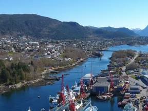
Ålesund is a modern and versatile city, known for its architecture, bustling port, and deep connection to the sea. As we approach the city centre, you’re looking at a place shaped by both catastrophe and innovation. Before the great fire of 1904, Ålesund was a thriving fishing town, with cod and clipfish as its main exports. Then came the night that changed everything – a single spark, strong winds, and by morning, nearly the entire town lay in ruins.
The rebuilding became a national effort. Young architects, inspired by the Art Nouveau movement, redesigned the city using stone and brick instead of wood. The result is what you see today – towers, spires, and curved facades in a unified, elegant style.
Today, Ålesund is a global hub for fishing, seafood, maritime technology, and innovation. The city exports everything from salmon to cutting-edge ship design and aquaculture systems. With top-level education and research institutions, Ålesund is now a centre for sustainable development – set in one of the most stunning coastal landscapes in the world.