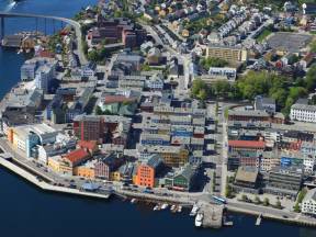
Here, right between the city center and the nearby islands and suburbs, you can open your senses, breathe in the fresh sea air, and let your gaze wander. Can you hear music? It wouldn’t be a surprise—Kristiansund is known as Norway’s opera city and is home to the country’s oldest opera company.
Along the harbor, you’ll see a mix of modern buildings and old warehouses. These used to be filled with clipfish—salted, dried cod—exported to Spain, Portugal, and the Caribbean. For over 200 years, this trade was the backbone of the city’s economy.
Today, you'll find cultural venues, hotels, and restaurants where the air once smelled of fish and seaweed. A bit further in, you might spot Kirkelandet Church, often called the Atlantic Cathedral. It’s considered Norway’s first truly modern church building.
Kristiansund is a vibrant, modern city with festivals, markets, and a strong boating culture year-round. It’s a place where the past and present blend seamlessly. As you stand here overlooking this beautiful coastal town, you’re witnessing a city that has reinvented itself—while always remembering where it came from.
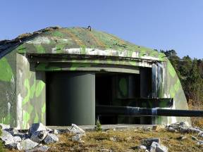
We are now passing the Agdenes Fortress area, strategically located at the mouth of the Trondheimsfjord. The artillery positions and guns were established in the late 1800s as part of Norway’s coastal defense system — a time when the nation was preparing for potential military threats, long before the outbreak of World War II.
Together with fortifications at Møvik near Kristiansand, Oscarsborg in the Oslofjord, and Karljohansvern in Horten, Agdenes formed part of a national strategy to secure Norway’s major fjords and access routes to key cities and naval bases.
Its location gave Agdenes control over all maritime traffic entering and exiting the Trondheimsfjord. The complex included gun emplacements, ammunition depots, observation posts, and barracks. To the north, you can spot the remains of Hysnes Fort, which — along with Brettingen and Hambåra — was part of the larger defensive network. Their combined firepower could cross the fjord and effectively close it off to enemy vessels.
During World War II, the area was seized and used by the occupying forces.
Although later modernized, the fortress gradually lost its military importance as the threat of war declined. Still, the site stands as a testament to Norway’s determination to protect its fjords and maintain control over its own destiny.
Do you see the church spire rising above the rooftops to the east?
That is Nordlandet Church, built in 1914, and one of the few large buildings that survived the bombing in 1940.
Nordlandet is perhaps the most homely and traditional of the city’s islands, with its old wooden houses, steep hillsides, and small gardens. From here, many had a clear view over the harbor, and it was home to sailors, fishermen, and klippfisk workers.
The women of the district were well known in the old days. They not only cared for home and family, but also contributed by mending nets and working in klippfisk production.
What people say about the women who live here today is unknown. What do you think?
We are now sailing under the Sørsund bridge between Kirklandet and Innlandet, the smallest of Kristiansund’s four city islands. Here you’ll find the city’s oldest preserved wooden buildings.
During the bombing in 1940, much of Kristiansund was reduced to ruins, but Innlandet remained almost untouched. Today, it stands as a living reminder of what the town once looked like.
As early as the 1600s, a small settlement began to grow here, known as Lille-Fosen. Timber trade flourished, and when the klippfisk industry boomed in the 18th and 19th centuries, the area expanded with narrow alleys, colorful boathouses, and lively piers.
Innlandet is also home to the city’s first school, first hospital, and first town hall. Place names like Hønebukta and Spanskesmuget still exist – as does Tahiti. Yes, you heard right: Tahiti. Perhaps the name reflects the warmth and energy of this neighborhood during the age of sail?
Today, you’ll find the Dødeladen cultural café, the Tahiti Pier, and the popular Tahiti Festival, all nestled in a district where the past still lives within the walls.
Now we’re sailing north along the Fosen Peninsula, a rugged and forested landscape where nature and culture have coexisted for thousands of years. Here, the fjord meets farms, old travel routes, and small communities shaped by pride and a strong sense of belonging.
The area you see now belongs to Indre Fosen Municipality, which stretches from the mouth of the Trondheimsfjord inland toward hills and forest. Here you'll find villages like Rissa, Stadsbygd, Leksvik, and Vanvikan, where people have lived closely with nature for generations, relying on farming, fishing, and small-scale industry.
Fosen has long been a crossroads between the inland and the coast, and between different cultures. Traces of Sámi settlements, Norse mythology, and Christian medieval life are found in place names, burial mounds, and the ruins of ancient monasteries.
On the opposite side of the fjord, you can see the village of Lensvik, the largest settlement in the northwestern part of Orkland Municipality. It's also known as the "Strawberry Village"—and with good reason. You'll have a hard time finding strawberries sweeter or juicier than those grown here.
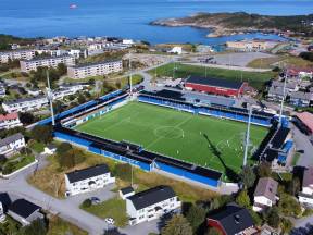
Looking toward land, you now see Kirklandet and the neighborhood of Clausenenga. It was right here, in a small garden with a garage wall as his goal, that one of the world’s most famous footballers, Ole Gunnar Solskjær, began his journey. He made his debut for Clausenengen Football Club at the age of 17, on the stadium you can see from the boat. His path led him to Norwegian top football and a brief spell at Molde, where he became the league's top scorer in his first season, before being signed by Manchester United in 1996.
He stayed with United for 11 years and is best remembered for his dramatic goal in the 1999 Champions League final, securing victory over Bayern Munich in stoppage time and completing the club’s legendary treble.
Solskjær scored 126 goals in 366 appearances for United and later returned as the club’s manager. His career has been remarkable, and he remains active as a coach — but he has never forgotten where he comes from.
We are now sailing between Klubba and Stavneset Lighthouse, with Kirklandet and Klubba to the northeast. From here, you have a rare and beautiful view of the city’s green edge. This area offers both fascinating history and stunning nature. Along the rocky slopes and pine forest near Klubba, you can still find traces of an old fortress, as well as other wartime remnants.
The area is a popular hiking destination for locals, with trails and viewpoints leading all the way toward the city center. Along the way, you can stop at Damman, a group of small ponds that once supplied Kristiansund with drinking water. Today, they serve as a peaceful retreat for leisure, nature, and cultural experiences.
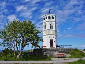
At the top of the ridge stands the Varden observation tower, which once served as a lookout post. From here, you can enjoy a spectacular panoramic view. In the northeast, the Nordmøre mountains rise majestically, and in the west, the vast and unpredictable Atlantic Ocean stretches beyond the horizon.
We are now sailing under the Nordsund Bridge, with Gomalandet to the west and Nordlandet to the east.
Gomalandet is the district of industry and workers. Since the 1800s, it has been home to shipyards, fish processing plants, and mechanical workshops. Today, modern businesses stand alongside old warehouses, and this is where many of the city's new housing projects and developments are taking shape.
The name Gomalandet comes from the nearby Goma River, and just beside it lies Kristiansund Stadium, the home ground of Kristiansund Ballklubb, which has played in Norway’s top football divisions for several years. Gomalandet also played a vital role in the city's resistance history, as many locals were involved in underground activities during the war.
Today, the area is undergoing change, with new neighborhoods and improved connections to the rest of the city. As we now glide beneath the bridge, you see a district that has always been alive with activity and is now building a new future, stone by stone.
You are now at a rare kind of crossroads — not of roads, but of fjords. Like a junction where highways meet, these fjord arms stretch out in every direction, like lifelines woven into the Norwegian landscape.
To the north, the Trondheim Fjord continues toward Levanger and Innherred, a region where farming and history go hand in hand. This is the landscape where Saint Olav spent much time with the powerful Earls of Lade before the Christianization of Norway.
To the west, the fjord opens up toward Ørlandet and the open ocean — a rugged coastline marked by military installations, bird sanctuaries, and a rich fishing heritage. From here, both Viking ships and cargo vessels once sailed out into the world.
To the south, Korsfjorden cuts inward toward Orkanger, once a bustling industrial hub, now a blend of heavy industry, culture, and coastal nature.
And to the east lies Flakkfjorden, leading into Trondheim and the Nidaros Cathedral — a destination for traders, kings, and pilgrims for centuries.
It’s not a traffic light we’re passing, but in the old days, these fjords were the highways of Norway — and this was a major intersection.
Far out to the west, about twelve kilometers from the mainland, lies the idyllic island group and former fishing village of Grip. Fishing was the foundation of life for the people who lived here, and already in the Middle Ages, Grip was an important and thriving fishing station. The islands were inhabited from early medieval times, but in 1974, the last permanent resident left the island.
In earlier times, seasonal fishermen from all over the county would gather on Grip during the spring cod fishing. The islands were bustling with life during those intense weeks out in the open sea.
Until 1964, Grip was Norway’s smallest municipality. Although the islands are now uninhabited, the colorful houses still stand as holiday homes and reminders of the past.
On the island, you will find the Grip Stave Church, dating back to the 15th century. You can also see Grip Lighthouse, built in 1888. It rises 44 meters above the ground and remains a well-known landmark for passing ships.
With its bright houses, coiled ropes, and old fishing nets, Grip offers a truly unique atmosphere. Would you like to visit? During the summer months, there are daily boat departures from Kristiansund.
The Norwegian Oil Adventure
Far out in the Norwegian Sea, some of the world’s most advanced oil and gas platforms rise above the surface like gigantic trolls. These structures are the beating heart of the Norwegian oil adventure—an industry that has shaped the nation, funded its welfare system, and laid the foundation for what is now called the Oil Fund, one of the world’s largest sovereign wealth funds.
Platforms like Ormen Lange, Njord, Draugen, Åsgard, and Heidrun have produced immense value. The natural gas and oil extracted from these fields are exported across Europe and continue to generate vital revenue for Norway—even after more than 50 years of production. The technology involved is cutting-edge, with many of the installations located deep beneath the ocean floor.
The platform names are not chosen at random. They are drawn from Norse mythology and royal sagas: Ormen Lange was the legendary longship of King Olav Tryggvason, Njord is the god of the sea, Draugen a sea spirit or ghost, while Åsgard and Heidrun come directly from the Norse realm of the gods. This is Norway in a nutshell — where history and modernity meet, where innovation walks hand in hand with tradition, and where global knowledge flows together in one place.
And yes, of course there’s a field called Troll. This is Norway, after all. But that one lies a bit farther south.
We are now passing Sør-Smøla, looking out over an archipelago that seems to stretch endlessly toward the horizon.
Here, more than 6,000 islands, islets, and skerries surround the main island and the municipality of Smøla. This gives the area a stunning coastline of around 2,500 kilometers – more than half the length of the entire coast of Denmark! By comparison, only a few thousand people live in the municipality, which means there's well over one island per person, if you count it that way.
People here have lived from the sea for generations. Many of the small islands once hosted bustling fishing communities, such as Lyngværet, Valøya, and Hallarøya, but most are now uninhabited and serve as peaceful holiday retreats.
That doesn’t mean the islands are empty. This is a haven for wildlife: white-tailed eagles, otters, and thousands of other species thrive here. With its kelp forests, shallow bays, and brackish inlets, this is one of the most biologically diverse coastal areas in Norway.
Yet this unique landscape also faces challenges – invasive mink, overgrowth, and ocean litter. Local efforts like controlled burning, livestock grazing, and beach cleanups help protect a coastline that still breathes, lives, and tells its story.
To the east, the mountains of Tustna and Stabblandet rise steeply from the sea — known as the Tustnastabban — like trolls turned to stone at sunrise.
This island landscape is known for its dramatic peaks, sheltered coves, and scattered farms. Many locals still live off fishing, goat herding, and small-scale agriculture. In earlier times, Tustna was also an important hub for boat building, and the mountains are tied to old tales of love and sorcery. The island may seem quiet and humble, but the nature, as you can see, is grand and powerful.
From the sea, you’ll spot peaks like Skarven, Stabben, and Jurtinden rising above the coastal passage. On calm days, they reflect on the water's surface with an eerie stillness. And if you're up for a real challenge, consider the Seven Peaks Nightmare – an extreme mountain trek across all seven of Tustna and Stabblandet’s peaks. That’s over 30 kilometers and 3,400 vertical meters, including climbing, narrow ridgelines, and views you’ll never forget.
These mountains are always listening. Ask them a question — and if you’re quiet enough, they might just answer.
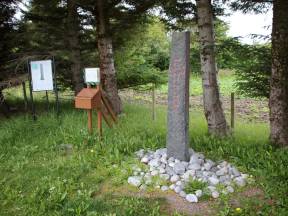
We’re now passing one of the most historically significant places in all of Norway. Just to the west, behind the island of Edøya, lies the small island of Kuli. Over a thousand years ago, a stone was raised there—now known as the Kuli Stone, often called “Norway’s baptismal certificate.”
Why? Because this stone contains the first known use of the name “Norway” on Norwegian soil. It also marks one of the earliest references to the arrival of Christianity in the country.
One side of the stone features a carved cross. On the two narrow sides are runic inscriptions, including these words:
“Tore and Halvard raised this stone after Ulfljot. Christianity had been in Norway for twelve winters.”
The stone was long believed to date from around the year 1034, but recent research suggests it may be even older.
In 2012, the Kuli Stone was added to Norway’s official documentary heritage, part of UNESCO’s Memory of the World program. That recognition confirms its status as one of the most important written records in Norwegian history.
The original is now housed in the medieval exhibition at the NTNU University Museum in Trondheim, but a faithful replica stands on Kuli—right where the original likely stood.
To the west, we now pass Edøya, an island with roots stretching back over 3,000 years.
In the Middle Ages, this was both a political and religious center, and at the heart of the island stands the Old Edøy Church, built in the late 12th century.
Not far from the church, a remarkable discovery was made in 2019 — a large Viking longship was detected underground using ground-penetrating radar. This find strongly supports the theory that Edøya was once home to a local chieftain during the Viking Age.
Much of this history is preserved and shared at the Gurisenteret, a modern cultural center nearby. It also hosts the open-air play Fru Guri av Edøy, a powerful drama about Guri, a strong woman from the 13th century torn between faith, loyalty, and love in a time of unrest and power struggles.
The Viking heritage of Edøya and nearby Kuli Island, just to the west, has put this region firmly on Norway’s historical map. Though small in size, Edøya holds great significance.
The island is connected by ferry to Tustna and has daily boat routes between Kristiansund and Trondheim.
To the west, Smøla rises beautifully on the horizon, poised between sea and sky.
This is a municipality made up of one large island and thousands of smaller ones, where traditional coastal life blends seamlessly with modern industry. Here you’ll find fishing, aquaculture, wind power, and agriculture—and not least: the legendary Smøla carrot. It’s said to be so strong, it pulls itself out of the ground without help.
At the northern tip lies Veiholmen, a historic fishing village that today thrives as a vibrant community and a magnet for visitors.
On Smøla, you can paddle a kayak between islets and reefs, sleep under the stars in a lean-to shelter, go on a sea eagle safari, play golf with the horizon as your backdrop, or dive into old shipwrecks and mysterious kelp forests.
Smøla offers grand experiences in nature. Here, you get all kinds of weather—and a healthy dose of authentic coastal culture, served with a twinkle in the eye and a carrot on the side.
Do you like salmon? Then chances are high that you’ve tasted one raised right here, in the waters around Trondheimsleia. Between the islands of Smøla, Hitra, Aure, Heim, and Frøya, you’ll find some of the world’s most productive areas for salmon farming. Ocean currents, clean seawater, and deep fjords create ideal conditions for aquaculture.
The giant company SalMar, based in this region, is one of the world’s largest exporters of farmed salmon. Every day, thousands of tons of fresh salmon are shipped from these fjords to markets all over the globe. In Norway alone, salmon worth more than 130 billion kroner is exported each year—and much of it starts right here, in the sea pens you see below.
The aquaculture industry provides jobs for many people locally, but it has also sparked debate. How can we balance food production, environmental protection, and animal welfare in the ocean? It’s a question that concerns both researchers and the general public.
But one thing is certain: out here along the coast lies one of Norway’s most important industries—and who knows? The salmon swimming below might just end up on your plate. Bon appétit.
Mot vest, mellom øyene Hitra og Smøla, finner vi Frøya, en flat og værbitt øy, men rik på liv. I dag er det moderne oppdrettsanlegg, vindkraftverk og små samfunn som preger øya. Men under overflaten, både bokstavelig og billedlig, ligger der tusen år med kystkultur.
Der ute i havgapet har folk levd av havet så lenge det har vært mennesker i Norge. Øya var trolig en av de første områdene i Norge som ble isfrie etter den siste istiden, og huser kanskje landets tetteste nettverk av gravrøyser fra bronsealder og jernalder.
Fisket etter havets sølv, silda, og torsk, formet generasjoner, og selv i dag kjenner mange seg mer som “havfolk” enn landboere. Frøya er også hjem for sterke tradisjoner innen båtbygging og sjømannskap. Når vi seiler forbi her i dag, kan du tenke på Frøya som et symbol på norsk kystkultur: værhard, tilpasningsdyktig, og sta som fjell.
Far out in the open sea, on the island of Frøya, lies the small fishing village of Titran. Today it’s a quiet and scenic place, but in the autumn of 1899, it became the site of one of the worst disasters in Norwegian coastal history. On October 13th, a violent storm struck without warning, and more than 140 fishermen lost their lives in what became known as the Titran Tragedy.
Weather along the Norwegian coast can be stunningly beautiful—but it can also turn in an instant. In the old days, there were no forecasts, no radios, and no GPS. The boats were open, and when storms hit, survival came down to skill, strength, and luck.
Every fishing village along the coast has felt the sting of loss. Wives left alone with children, boats that never returned, names never spoken again. In Titran, entire families were wiped out, and the sorrow left deep marks in local memory.
The story of the Titran tragedy reminds us how closely coastal communities have always lived with nature—and how much courage it has taken to live from the sea.
Did you know that this coastal region is among the most economically productive in Norway, measured per capita? Fewer than 20,000 people live here, yet they generate salmon values worth tens of billions of kroner each year. The salmon swimming in the sea pens off the coast creates jobs both at sea and on land — in slaughterhouses, packing facilities, transport, technology, and research.
Today, aquaculture is the driving force behind many local communities. The industry makes it possible to live and work here, and it has also contributed to new infrastructure, better schools, and a rich cultural life. The value created per inhabitant in these municipalities is among the highest in the country, and the export revenues from here help finance everything from hospitals to highways across Norway.
But did you know that it’s not just salmon that comes from this region? Out in the ocean, directly west of us, lie some of Norway’s most important oil and gas fields — such as Draugen and Ormen Lange. Together with aquaculture, wild-catch fisheries, and offshore wind power, they make this region an economic powerhouse for the entire country.
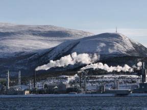
We are now passing Tjeldbergodden on the mainland side — one of Norway’s most advanced industrial facilities. Here, natural gas from the Heidrun platform arrives via the Halten pipeline and is processed into methanol, an important raw material used in global industry.
Completed in the late 1990s, this facility marked a turning point in the way the coast is used — shifting from traditional fishing and transport to gas processing and international industry. Tjeldbergodden also represents Norway’s ability to take control of its own resources, from raw material to finished product. The site has played a key role in gas distribution to Central Norway and stands as a powerful example of how small, remote places can become hubs in large global value chains.
At the same time, the facility sits in a stunning natural setting. The contrast between pipes, mountains, and fjords says a lot about this country. As you sail past, you’re not just seeing industry — you're witnessing a coastline in transition, where the age of oil and gas leaves lasting marks, both for better and worse.
We are now sailing along the island of Hitra — one of Norway’s largest islands, surrounded by over 2,500 islets, skerries, and reefs. Hitra is especially known for deer hunting, salmon farming, and fishing.
The island boasts around 7,000 lakes and ponds, many of which are excellent for trout and char fishing. There are also a few salmon rivers with good catches. Hitra is home to one of Northern Europe’s largest populations of red deer.
This is a place where old and new meet — from Viking Age settlements and traditional farming and fishing to today’s modern society built on innovation and technology. Hitra has grown into a business hub in the region, with wind power, advanced aquaculture, and modern industry forming the backbone of its economy.
In earlier times, sailing ships called jekter carried fish and goods from Hitra. People here were known for managing both their natural resources and their stories. Today, the island stands as a symbol of how the Norwegian coast continues to evolve, while still preserving its rich and diverse history.
If you look up, you might be lucky enough to spot the white-tailed eagle, the largest breeding bird of prey in Northern Europe. Here in the Trondheimsleia strait, it has found its paradise, with steep cliffs, open seas, and an abundance of fish. With a wingspan of up to 2.5 meters, it is a majestic sight as it glides effortlessly over islands, skerries, reefs, and boats.
After being nearly extinct in Norway during the 20th century, the white-tailed eagle has made a spectacular comeback. The islands around Hitra, Smøla, and Frøya now host some of the largest breeding populations in all of Europe. In earlier times, it was seen as an omen—sometimes good, sometimes bad—and it features often in legends and seafarers’ tales.
Today, it stands as a symbol of freedom, survival, and the wild spirit of the coast. Perhaps you’ll see the eagle circling above the boat right now, scanning for prey—or simply asserting its role as the true king of the coast.
How do you keep a community alive when the man is at sea for weeks, or perhaps never returns?
The coastal women of the old days had no time to call themselves heroes, but that’s exactly what they were. They cared for the children, cleaned the house and clothes, cooked meals, and fed the animals. If necessary, they chopped firewood, repaired the boat, and weeded the fields. They knew how to read the weather, mend fishing nets, and sew clothes from sailcloth. When the storm raged, they went out with the lantern, searching for the boat, and prepared to receive those returning from the sea. When death came, they carried their grief in silence and carried on with life.
In many places, it was also the women who made sure the children got to school, the potatoes were planted, and the barn was tended before sunrise. Often, it was the women who could write, do arithmetic, and negotiate. The lives and work of coastal women were two things inextricably linked. Without their labor, knowledge, experience, and versatility, the old coastal communities could not have survived.
Have you heard of Guri Kunna?
She is a figure from old legends and coastal tales along Norway’s shores. Described as a wise woman who could summon both storms and calm seas, she was viewed with both reverence and awe. Guri Kunna symbolized the power of nature, female strength, and the seafarers’ deep respect for the unpredictable ocean.
But Guri Kunna is more than just a myth. Her name lives on as a source of inspiration for the future. Here, in the heart of coastal culture on the island of Hitra, you'll find Guri Kunna Upper Secondary School. This is where young people learn about modern industries such as aquaculture, technology, climate, and sustainability — all closely connected to the nature and community around them.
Much like the legend itself, the school bridges past and present. It shapes the next generation of coastal women and men — with knowledge, strong roots, and eyes set on the sea. Perhaps one day, they will command ships, lead sustainable food production, or write new stories about life by the ocean.
The coast needs such voices — strong, wise, and courageous — just like Guri Kunna herself.
We are now passing 264 meters above the Hitratunnel, which opened in 1994. It is one of Norway’s deepest subsea road tunnels. In a country of fjords and islands, tunnels like this are essential. Today, Norway has nearly 40 subsea tunnels, along with over 1,200 other road tunnels with a combined length of 1,550 kilometers — that’s roughly the distance of a tunnel stretching from Berlin to Rome. And if you added the length of Norway’s 18,000 bridges, you’d probably make it all the way to Africa.
Just look around, and it’s clear: building infrastructure in Norway is both challenging and expensive.
Still, tunnels and bridges like these are vital for coastal communities, such as here on Hitra. Suddenly, it became possible to transport fish, people, and goods to the mainland year-round — quickly and safely.
The Hitratunnel stands as a powerful example of how Norway invests in vibrant coastal societies that, in turn, contribute to the country’s welfare and growth.
Weather Forecasting in the Old Days
Out here along the coast, the weather is unpredictable, even today, with expert meteorologists and a sea of satellites at their disposal.
But before modern forecasting, coastal people had to read the signs themselves. And they took it seriously. They watched the sky, the birds, the sun, and the animals. A red sunset meant good weather. A ring around the moon warned of rain. If the seagulls flew high, the skies would be clear. When the sheep huddled together, a storm might be brewing.
People read the patterns in seaweed and foam, in air humidity and scent. Wisdom was passed down through generations.
Both men and women developed a sharp eye, and an inner barometer.
Even after radio and television arrived, many still trusted Grandpa’s gaze more than the forecast from the city.
Some had their own signals:
Three crows flying east meant a storm. Four heading west; calm seas.
And what kind of weather do you think was coming,
if your wife came running after you with a rolling pin?
The stretch we’re sailing through now is known as the Trondheimsleia, one of Norway’s most important historical sea routes. It runs for about 170 kilometers and is naturally protected by islands, mountains, and skerries.
This made it ideal for sailing ships, coastal cargo vessels called jekter, and Viking longships — and later for steamships and high-speed ferries.
Today, it’s part of the main shipping lane along Norway’s coast, with tens of thousands of vessels passing through every year. Some parts of the Trondheimsleia are as deep as 500 meters, and navigating it requires deep knowledge of currents, winds, and narrow passages — especially in bad weather.
Along the route, you’ll find several lighthouses and beacons to help ensure safe passage. One of them is the Terningen Lighthouse, which we’re passing now. First lit in 1833, it features a 12-meter tall concrete tower with a focal height of nearly 18 meters above sea level. That gives it a range of 13.4 nautical miles — or about 25 kilometers.
As we sail on, we’re following in the wake of countless generations who have relied on this seaway, from Viking warriors to modern mariners.
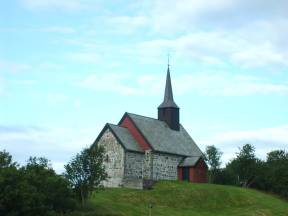
On the other side of the island of Hitra, with a beautiful view of the sea, lies Dolm Church, one of the oldest church buildings along the Trøndelag coast still in use today.
We don’t know exactly when it was built, but it likely dates back to the 15th century, when Dolm became the center of one of Norway’s wealthiest parishes. In the Middle Ages, this was a major religious hub for islanders, and many came here for baptisms, weddings, or mass. Some may have come simply to seek comfort and hope in a time when life was often challenging. The church is often associated with the pilgrim tradition and the journey toward Nidaros in Trondheim, which was the most important holy site in Norway at the time.
Dolm Church is also the setting for the annual “Maren Play,” which tells the story of Maren Johanne Olsdatter Jektvik, who was sentenced to death on Dolmøya in 1849. Maren was accused of poisoning her husband. She initially denied the charges but later confessed and was executed by beheading that same year.
Dolm Church thus tells more than just the story of religious life, it preserves the memory of the everyday lives and dramatic events of those who lived here long ago.
Out here, people lived in small, scattered communities — often just a few families, a handful of sheep and goats, and an open rowboat as their only connection to the outside world.
Life was tough, but it was close-knit. The sea gave and the sea took. It decided what you ate, when you could sleep, and whether you could make it to a christening, a wedding, or even a funeral.
There were no shops — only what you could grow, fish, or trade for.
Communication with the world came through letters, and they might arrive just once a month. If you were going to church or school, it was by rowboat and your own two feet.
But in the middle of this simple life, there was warmth. Your neighbour was never far, and community work was essential to survival. Evenings were filled with stories by the wood stove, the scent of salt and seaweed in the air, and children running barefoot over heather and slick rocks.
As you watch the islands drift past, you might begin to imagine what life was like here, long ago.
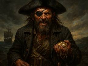
The pirate, Johannes Blank
Watch out for your wallet, phone, jewelry—and even your gold teeth!
You’ve now entered the realm of the pirate Johannes Blank! In these very waters, one of Norway’s most notorious pirates once ruled the waves. Johannes Blank—a name that still stirs the memories of coastal folk.
In the late 1700s, he hijacked ships, looted trade goods, and spread fear from Nordmøre to Trøndelag. He especially haunted the narrow straits around Smøla and Kristiansund, using skerries and islands to hide both himself and his treasures.
He was known for being cunning, swift, and ruthless. But in the end, justice caught up with him. He was captured, sentenced, and publicly beheaded as a warning to others.
Today, local legends still whisper about the places where he hid his treasure. Some even claim to have seen glittering coins on the rocks at sunset. So if something shines in the shoreline as we pass... who knows? It might just be one of Johannes Blank’s hidden treasures!
Imagine yourself a thousand years ago.
You’re sitting in an open boat, the wind howling and the waves beating rhythmically against the hull. You're headed toward Trondheim, to visit the grave of Saint Olav.
Right now, we are sailing through the Trondheimsleia, a part of the ancient coastal route to Nidaros that has been followed by pilgrims from all over the world for centuries. This route is known as the Coastal Pilgrim Path, Kystpilegrimsleia, and it stretches from Egersund in the south to the Nidaros Cathedral in Trondheim. During the Middle Ages, it was the most traveled pilgrimage route in Norway.
In a way, we are following in the footsteps of Saint Olav and the Christianization of Norway. Between Kristiansund and Trondheim alone, there are six official key sites, where you can learn more about the history, the life of Saint Olav, and the rituals of medieval pilgrimage.
Perhaps someone on our boat right now is carrying a backpack and an open heart, heading toward Nidaros and Trondheim, just like the pilgrims have done for nearly a thousand years.
Far out in the sea, where waves crash against low skerries and the wind carries stories from centuries past, lie Froan and Sula. This is the outermost edge of Trøndelag, a stunning archipelago made up of hundreds of small islands, islets and reefs, with names that taste of salt and time: Sørburøy, Sauøy, Halten.
In the middle of this weather-beaten seascape stands Sula Chapel, built in 1925, though the site has served as a place of worship since the 15th century. Today, the chapel remains open year-round, offering a quiet refuge for both islanders and pilgrims.
Sula is also a key stop along the Coastal Pilgrimage Route – the historic sea path to Nidaros. In the Middle Ages, pilgrims came ashore here to pray, rest or seek shelter from the storm.
Known as “the white town in the sea”, Sula is a living fishing village, rich in tradition and community spirit. It’s home to galleries, a pub, a restaurant, guesthouses and a well-used village shop – still the heart of the island.
Froan and Sula tell the story of people who have always lived with the sea, never against it.
Now we are approaching Ørlandet, a place where history and the future quite literally fly side by side.
Here, in the flat and weather-beaten landscape, you'll find Ørland Air Station and Ørland Civil Airport.
The air station is one of Norway’s most important military and strategic bases. It was first used as an airfield during World War II, and today it serves as the main base for Norway’s fighter jets, including the cutting-edge F-35s. Ørland plays a vital role in NATO’s defence structure and hosts frequent training exercises with international forces.
But Ørlandet is more than just military power. The civil airport offers regular flights, including routes to Oslo, helping to connect this coastal region to the rest of the country. Right nearby, you’ll also find cultural highlights like the Ørland Cultural Centre and historical landmarks such as Austrått Manor, making this a place where technology, heritage, and art meet.
As we sail past, you might hear or even see a jet soaring overhead. For some, the sound may be intimidating, but for others, it sparks safety, fascination and wonder.
And if you spot an F-35 in the sky, just remember: it's Ørlandet, watching over the coast.
Could you imagine growing up on one of the islands we're now passing? In earlier days, children along the coastal route lived close to life’s realities.
Many had to carry water, row to the store, watch sheep, or care for younger siblings from an early age. School was not a given, and some had to walk over mountains or row for miles just to get there.
Still, there are countless stories of play, songs, and imagination. What they all have in common is that children used their surroundings and made their own toys. Hide-and-seek, jumping in hay, and playing with homemade boats, swords, and dolls were popular activities.
Their small communities were often the only world they knew, and they knew everyone on the island. At the same time, they learned responsibility, togetherness, and pride. Many of those who now hold important positions in Norway grew up or have roots on islands like these – carrying with them the strength of a childhood where everything mattered.
Are you ready for something spooky?
Along the Norwegian coast, old legends tell of strange and eerie creatures — and Margyge is one of the most feared. She is said to be a woman of the sea, beautiful from a distance, but deadly if she gets hold of you. With long dark hair, scaly skin, and a chilling stare, she waits for unsuspecting sailors.
Margyge often sat on rocks, skerries, or cliffs, singing or weeping to lure seafarers closer.
As they approached, she would overturn their boats and drag them down into the deep.
Some believed she was a cursed woman, others said she was a spirit — half human, half sea.
Margyge is often linked with storms, shipwrecks, and tragedy. She could even be seen as a warning: if you spotted her, you were meant to turn back. Like the havmann or the draug, Margyge was a way to explain the unexplainable, especially when young sailors vanished without a trace.
And now you might want to think twice…
What would you do if you saw a young woman, alone and weeping, sitting on a rock in the sea?
We are now rounding the decommissioned Agdenes Lighthouse, visible on the hillside above with a wide view over the seaway. This marks the transition between the Trondheim Fjord and the Trondheimsleia strait — a strategic point where the fjord opens to the sea.
Established in 1804, Agdenes Lighthouse is one of the oldest in the country. It was manned for more than 150 years and helped guide ships safely in and out of the fjord. Today, the buildings are unstaffed but remain an important cultural landmark and are used as a place to stay overnight. Just below lies the automated beacon at Ringflua, which still aids vessels in navigation.
On the opposite side of the fjord, you can spot Brettingen Fort, a coastal battery built by the Nazis during World War II. The combination of lighthouse and fort reminds us how this area has been watched and defended for over two centuries.
Now it’s our turn to follow this historic route, just like the Vikings, merchants, and sailors have done for centuries — with Agdenes standing guard at the gateway to the Trondheim Fjord.
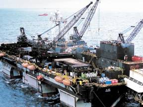
Just west of us, far out in the Norwegian Sea, lies the enormous Ormen Lange gas field.
It is Norway’s second-largest gas field in operation, and a true technological marvel. The sea depth out here ranges from 800 to 1,100 meters, yet we have managed to extract natural gas from a landscape no human has ever set foot in.
The gas is transported through subsea pipelines to the processing facility at Nyhamna, on the island of Gossa, just west of Kristiansund. From there, it continues to Easington in England via a 1,300-kilometre-long pipeline, more than one meter in diameter. Production began in 2007, and daily output has reached up to 70 million cubic meters — enough to supply millions of households across Europe. This represents a daily value of over 20 million euros.
The name Ormen Lange is taken from the old Norse sagas. According to Snorre Sturlason, it was the majestic longship of Olav Tryggvason, built in the tradition of dragon-headed warships. Just like the ship once ruled the seas, today’s Ormen Lange dominates the deep — with power and a steady course into the future.
Now we’re passing one of the most intriguing places along this journey, King Øystein’s Harbour. Believed to have been built in the early 1100s, this is considered one of Norway’s oldest harbours constructed for military purposes. It offered shelter and a place for royal ships to gather strength before setting out on Viking expeditions. According to Snorre’s royal sagas, it was King Øystein Magnusson who commissioned the harbour.
Recent studies suggest that parts of the structure may date as far back as the 900s. That means this site was likely an important gathering point for Viking fleets heading out toward Europe, whether to trade, settle, plunder, or explore new lands.
The sagas portray King Øystein as blue-eyed, cheerful, wise, and eloquent , a charismatic leader with both authority and compassion. It fits well with this location: a safe harbour in troubled waters, echoing with stories of sails, shields, and sea-bound destiny.
We’re now approaching Pirbadet and Brattøra, the modern district that stretches into the fjord as an extension of Trondheim’s city center. Pirbadet is one of Norway’s largest indoor water parks, featuring warm pools, water slides, training facilities, and saunas — all with panoramic views of the very waters we’re sailing through now. It’s a popular destination for both families and professional athletes.
Once a bustling cargo port, Brattøra has been transformed into a vibrant hub of technology, tourism, and culture. It houses the central train station and terminals for express boats, ferries, and cruise ships. The area is also home to Rockheim, Norway’s national museum of popular music, and Powerhouse, a pioneering building designed for energy efficiency and sustainability.
Looking further inland, you’ll glimpse Trondheim’s beating heart: the town square, lined with shops and restaurants, and dominated by a towering statue of the city’s founder, Olav Tryggvason. And beyond that, rising above the rooftops, the majestic spire of Nidaros Cathedral catches the eye.
Trondheim offers much to experience and explore — and from here, it’s all just a short walk away.
Now you can see the tall spire and tower of Nidaros Cathedral rising majestically in the center of Trondheim. The spire reaches an impressive 91 meters into the sky and is visible from much of the city. This is Norway’s national shrine, built over the grave of Saint Olav, and it has been the destination of pilgrims from all over Europe for nearly a thousand years.
Construction began in the mid-11th century, and the cathedral was gradually expanded throughout the Middle Ages. It was adorned with sculptures, stained glass, and architectural details that made it one of the largest church buildings in Northern Europe.
Today, it serves as a church, museum, and ceremonial site. Since 1814, every Norwegian monarch has been consecrated and pledged their oath here, and the cathedral still gathers people for important national and spiritual moments.
As you see Nidaros Cathedral towering over the city, it’s like witnessing Norway’s history carved in stone. It speaks of faith and power, art and craftsmanship, sorrow and hope – and of people on a journey. Perhaps you are on one too, and maybe it ends right here, in the heart of Trondheim, where roads, stories, and generations come together.
We’re now passing Munkholmen — a peaceful, beautiful little island today, but one that hides a long and dramatic history. It was here in the year 995 that the founder of Trondheim, Olav Tryggvason, had Håkon Jarl and his slave Kark beheaded. Their heads were placed on a tall pole, known as a “nidstang,” as a warning to others.
Already in Viking times, the island served as an execution site, but by the 11th century, its role had shifted completely. A Benedictine monastery — one of the first in Norway — was established here, and it gave the island its name: Munkholmen, or “The Monks’ Islet.” For many years, it was a place of prayer, learning, and silence.
Under Danish rule, however, the island’s story took another turn. In the 17th century, it was converted into a fortress with thick ramparts and cannons, built to defend Trondheim from naval attack. It also became a state prison, housing high-profile inmates like Peder Schumacher Griffenfeld, once one of Denmark’s most powerful men.
Today, Munkholmen is a popular excursion spot for swimming, picnics, and guided tours. And if you're curious how it felt to sit in a cold, damp prison cell — you can still visit one. If you dare.
Trondheim is not only known for its ancient history – it is also a vibrant, modern city full of life, knowledge, and culture. The city is home to NTNU, Norway’s largest university, and serves as a national hub for technology, research, and innovation. Students from around the world gather here in an environment where tradition and future go hand in hand.
The city offers a rich cultural scene with concerts, museums, and festivals, and Trondheim’s food culture is rooted in local ingredients and creative chefs. It’s also a top-tier sports city. Rosenborg Football Club has long been one of Norway’s most successful teams, with proud traditions in both the national league and the Champions League. Byåsen Handball Club has produced several world-class players and remains a strong presence nationally and internationally.
But it is perhaps in winter sports that Trondheim has made its biggest mark. The city has hosted the FIS Nordic World Ski Championships multiple times, most notably in 1997 and 2025, and is the hometown of several winter sports legends. Among the greatest are cross-country stars Johannes Høsflot Klæbo, who dominated the 2025 championships, Petter Northug, Marit Bjørgen, and the beloved speed skater Hjalmar "Hjallis" Andersen, who won three Olympic golds in 1952.
In Trondheim, past and future meet – on the pitch, on the ski trails, and in the very heart of the city.
Here, at the entrance to Trondheim, you see one of Norway’s oldest and most significant cities. Trondheim was founded in the year 997 by the Viking king Olav Tryggvason and was originally called Nidaros, named after the river Nidelva that runs through the city. It quickly became both a political and religious center, and after the death of Saint Olav in 1030, Nidaros grew into one of the most important pilgrimage destinations in Europe.
Nidaros Cathedral, which rises in the heart of the city, was built over his grave and attracted pilgrims from all over the continent. Over time, the city flourished as a trading hub, with boats and cargo ships transporting goods along the coast and deep into the fjords.
Trondheim has seen fires, wars, and reconstruction, but today it is a vibrant university city with deep historical roots, still visible in street names and buildings.
We are now traveling the seaway as kings, traders, and pilgrims once did—perhaps with a bit more comfort—but with the same timeless aim: to work, to meet, or simply to discover.
If you look up toward the hillside, you can just make out St. Olav’s Leap — a steep rocky ledge that drops dramatically toward the fjord. Its name carries one of the many legends tied to Olav the Holy.
According to tradition, Olav Haraldsson — later canonized as St. Olav — was once pursued through this rugged landscape by his enemies. When he reached the edge of the cliff, rather than surrender, he leapt. Miraculously, he survived the fall. Some say you can still see the marks from his landing etched into the rock. Whether fact or folklore, the story reflects how Olav quickly became surrounded by myths and miracles after his death.
Olav was not only a king and warrior, but also became the very symbol of Norway’s Christianization. After falling in battle in 1030, he was declared a saint just a year later in 1031. Places like St. Olav’s Leap became spiritual landmarks along the pilgrimage routes leading to Nidaros Cathedral in Trondheim.
The name Trolla might send a little shiver down your spine. In a land where mountains can resemble sleeping giants, and mist looks like the beard of a hulder – a forest spirit from folklore – it’s easy to let your imagination run wild.
We’re now passing the village of Trolla, surrounded by steep cliffs and dense forest. Today, it’s best known as a residential and industrial area, but you can see why its name brings trolls to mind. Perhaps there was once an old tale that’s now lost to time, or maybe it was simply the dark silhouette of the mountains at sunset that inspired the name.
In Norwegian folklore, trolls were said to live in these very hills. They were large, shaggy, and not particularly clever. In the recent Norwegian blockbuster Troll, a giant creature is awakened in the Dovre mountains. The film blends thrilling action and spectacular effects with age-old folklore to create a fun monster story for the whole family.
Long before film and video, stories like these lived through vivid storytelling. Children and adults alike were swept away by them—and across Norway, you can still see traces of that imagination in place names. Just like here, in Trolla.
The Coastal Heritage Museum
We’re now approaching Stadsbygd to the north, home to one of Norway’s most important cultural heritage museums: Kystens Arv — The Coastal Heritage Museum.
This museum preserves the knowledge, craftsmanship, and stories that shaped coastal life for centuries. You’ll find everything from hand-built wooden boats and fishing gear to ropes, rowing traditions, and everyday life by the sea.
At the museum, you can watch skilled boatbuilders at work using the ancient clinker-building method — the same technique used by the Vikings. This tradition is so valuable that it has been inscribed on UNESCO’s list of Intangible Cultural Heritage.
For hundreds of years, Stadsbygd has been a key hub along the fjord — a harbor, a trading post, and a gathering place for coastal communities. People here lived in close harmony with the sea: they fished, rowed, sailed, and built the boats that carried them out into the wider world.
That’s how it often was in small coastal communities: they lived off the land and sea, and came together to build homes, boats, churches — and a shared future.
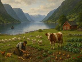
You're now looking out over a landscape where short-traveled food wasn’t just a trend — it was a way of life. Today, the term often evokes images of premium ingredients, organic farming, and artisanal production. But for the people living along these fjords in the past, all food was local — simply because it had to be.
Along the fjord arms and in the small villages, people survived on what they could gather from the sea, the forest, and their small plots of land. Fish came straight from the water, often ending up in the pot the very same day. Potatoes, rutabagas, onions, and berries were grown behind the house or foraged nearby. Sheep grazed in the hills, and milk came from the family’s own cow. Nothing was wasted.
Food was more than nourishment — it was community, tradition, and pride. Recipes were handed down through generations, and every dish carried the flavor of the land it came from.
So next time you hear the phrase “local food,” think of what you're seeing right now. Small communities living in harmony with nature, drawing all they needed from this very place. Perhaps that’s the most exclusive kind of food there is.
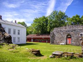
High on the hill above the village of Rissa lies Reins Monastery—a place where old stones still whisper stories of faith, power, and change. The monastery was founded in the 1220s, likely as an Augustinian convent for women of noble birth. Its location was no coincidence: Reins had earlier been a royal estate tied to several Norwegian kings as far back as the 900s.
During the Middle Ages, there were around 30 monasteries spread across Norway. They served as centers of prayer, learning, agriculture, and social care. But after the Reformation in the 1500s, most monasteries were closed down, confiscated, or turned into farms. The same fate met Reins, which later became a manor estate—a farm that still stands today.
What makes Reins special is how its history remains visible. The buildings reflect different eras, and archaeological finds reveal traces of the monastic life buried beneath the ground.
When you look up toward the ridge in Rissa, you're seeing a rare site in a Norwegian context—where kings, nuns, and noble figures once gazed out over the fjord, toward exactly where you are sailing now.
We are now approaching Rissa, a region known for its stunning scenery, dramatic history, and strong sense of community. But perhaps Rissa is best known for a landslide that shook the entire nation of Norway.
On April 29th, 1978, a quick clay landslide occurred here, sending massive amounts of earth crashing down the slopes. 20 houses and farms was swallowed by the collapsing ground, and an entire residential area had to be evacuated. One person tragically lost their life, but the disaster could have been far worse. The landslide was captured on film, and the footage has since been used around the world to study this dangerous soil type. The event led to a national effort to better map and secure quick clay zones throughout Norway.
But Rissa is far more than just the site of a natural disaster. It's a thriving community with proud traditions in farming, craftsmanship, and local industry. The area also boasts a high school, cultural center, and excellent hiking opportunities — including scenic spots like Mount Rissafjellet and Lake Botn.
As the landscape drifts past your window, reflect on the many chapters of life here — both the dramatic and the everyday — and how the people of Rissa have rebuilt, adapted, and maintained their close bond with nature and each other.