On behalf of the captain and his crew, we wish you a warm welcome on board. For the sake or your own safety, we ask you to pay close attention to this announcement:
Please make a note of where the emergency exits and fire extinguishers are located. They are clearly marked, and signs on the walls point to where they can be found.
Life jackets are carried for all passengers on board. They are located in containers above the seats in the lounge. If instructed by the captain, you must put on a life jacket immediately.
Should we have to abandon ship, the crew will launch life rafts. Stay calm and alert, and follow the instructions given by the captain and the crew.
We remind you that smoking is not allowed anywhere aboard the vessel.
Thanks for your attention. We wish you a pleasant and memorable journey on board
Welcome on board to this tour from the Art Nouveau city on the coast along the fjord to the little village of Geiranger. We will tell you a little about the things you will see– and more about the things you cannot see.
The trip will take approximately three hours. You will see the landscape gradually change from the open and airy expanses of Ålesund and the ocean, to the drama of narrow waters and steep mountainsides further inland. You will see some of Norway’s most spectacular landscapes from the vantage point on the water.
In earlier times, the 100 kilometre journey could last all day, depending on the boat. Many people therefore took this trip only once in their lifetime, and it had a very special meaning. We hope that you too will feel that this journey is something special.
Even though the people of Ålesund occasionally take a beating from the weather, the city’s location is perfect. Around a narrow channel between two islands, the farmer fishermen found a sheltered harbour. Rich fishing banks were a short distance away, making this an ideal place for trade.
Norway has been exporting stockfish to Europe since the early Middle Ages. The demand for stockfish was driven by the Catholic ban on eating meat during Lent, and also because fish that could be stored and transported over long distances was highly valued. Because the climate on the northwest coast is ideal for drying salted codfish, conditions were ripe for increasing fish exports from this region from the late 18th century. The dried cod industry was the reason why Ålesund was granted city status in 1848, and since then, the city has developed into Norway’s main fishing port and the largest export harbour for fish. Today, Ålesund is home to nearly 50 000 people.
Ålesund is also known for its characteristic Art Nouveau architecture, which appeared after the catastrophic fire that raged one January night in 1904. 850 buildings were destroyed in the fire that left 12 000 people homeless but claimed only one fatality. Help came from near and far, including architects with new ideas. In only a few short years the city centre was rebuilt, with masonry buildings designed in modern styles taken from contemporary Europe.
Ålesund therefore remains confident in its identity as the fishing capital of the Sunnmøre region, while keeping its eyes on the horizon, other ports and new impulses.
Here in the North, the winter nights are long and the summer nights bright.
Perhaps that’s the reason why we love bonfires? One thing is certain: sitting around a bonfire and staring into the flames on a bright summer night has a very special place in our hearts.
Young people from different parts of Ålesund used to compete in building the largest and finest bonfire on Midsummer Night. You wouldn’t believe how much energy, cunning and youthful fervour they were able to muster in the battle to win. Today, bonfires are banned in the city centre, and their youthful passion is now instead devoted to building this remarkable engineering structure.
Every year, a group of young people build a huge bonfire on an islet by the large boathouse. They spend months on their edifice, climbing and stacking pallets while safely secured with modern climbing gear. On Midsummer Night, the 23rd of June , they light the bonfire.
In 2016, a new world record was set by a more than 47 metres tall bonfire. However, the bonfire is always an extraordinary experience, even when no new records are set.
We are now sailing directly above our larder. The Borgund fjord is an important spawning ground for migrating cod, and every winter, from February to April, the Borgund fjord fisheries take place here, as has been the case for more than one thousand years.
An old written source dating from the 1760s estimates that the number of participating vessels was equivalent to 500 large fishing boats crewed by about 3000 fishermen. This did not include fishermen from other communities.
Most of the farms in the Sunnmøre region participated in these important fisheries. Farmer fishermen came from near and far. Even the farms in the innermost reaches of the fjord, and those far from the shoreline, would have a share in a boat and go cod fishing every year.
The fjord was crowded, and we can assume that there were numerous conflicts. We can barely imagine what it was like with so many farmer-fishermen pouring in. On the islands off Ålesund the islanders built boarding houses to accommodate all those who came to fish. The fishermen brought their own supplies with them, but paid for lodgings and the cook who prepared their meals.
Today, fishing is done with modern methods and in a more regulated fashion to protect the valuable cod stocks, but the spring fisheries remain a huge annual event, whether you are fishing for work or leisure. And isn’t it nice that you can use your fishing rod to catch your own dinner on an afternoon stroll in the centre of Ålesund?
Wherever fish abound and fishing is important, there will be skilful boatmen. And anyone who is good at building and repairing boats will enjoy great respect.
The 1860s saw the beginning of Ålesund’s deep-sea fishing adventure. The fishing fleet had previously consisted of traditional open boats but was now replaced by larger ocean-going vessels. Local boat building skills have been evolving ever since. Our many shipyards have launched all types of craft: trawlers, research vessels, cruise ships, ferries – and of course, this very one!
A few years ago, the Norwegian Maritime Competence Centre was set up at Nørvasundet in Ålesund. This maritime cluster forms part of Ålesund Campus, and brings together researchers, business interests and capital. The aim is to provide one of Norway’s most important focal points for the development of maritime expertise. The big building is home to an array of simulators designed to provide training facilities for people and ships involved with large-scale, complicated operations.
While the simulators are buzzing in the Competence Centre, the Borgund knarr bobs calmly at her mooring on the opposite side of the sound. This is a replica of a Viking merchant ship, more than a thousand years old. This type of vessel dates from the Early Medieval period – when Borgund was the regional hub for trade and fishing.
The knarr belongs to Sunnmøre Museum, which occupies the site of the old market town. The open-air museum has a number of old boats on display and serves as a centre of excellence for Sunnmøre’s maritime history.
In earlier times, the fjord was the highway. Even people who lived far away from the fjord needed access to a boat. For theirs was a life of rowing. They would row to visit their neighbours; they would row to church; they would row to collect fodder for their livestock and to take their kids to school. They would row to fetch the midwife or the doctor, or to assist livestock in trouble on the hill. They would row for fishing. Everything they produced for sale, and everything they needed to buy, was carried by sea.
The first coastal steamer arrived in 1857. From 1870 onwards, there was a weekly service between Ålesund and Geiranger. Since the 1900s the fjord has been busy with all sorts of vessels, including many cruise ships.
The steamer was a welcome visitor, but if people on remote farms were to make use of its services, they would need to row out and wait mid-fjord. Milk boats carried milk from farms to dairies. There was a passenger ferry, an ambulance boat, a doctor’s boat and a church boat. And sometimes the local service boat would be all of these things in one.
All the while our roads were being improved, and with better roads came more cars. The first car ferries were introduced in the 1920s, and since then, road transport has become increasingly important. In the 1960s we started making tunnels through the mountains. This gave us snow free roads, and a quicker route to hospital. These days of course, lifesaving treatment is only minutes away by rescue helicopter.
Still – this boat between Ålesund and Geiranger actually offers the most efficient route. There is no need to wait for a ferry or to be delayed by slow drivers amidst the tourist traffic. Instead, you can lean back, take in the fresh air, enjoy a refreshment and allow yourself a rest for as long as the journey takes.
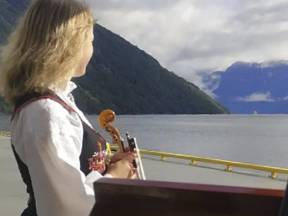
The Sunnmøre region is rich in musical traditions. Virtually every village has a choir, an orchestra or a dance band, and the vibrant traditional music scene allows everybody to play and sing to their heart’s content.
Weekdays and holidays are accompanied by music, to celebrate love and provide comfort in grief. Moreover, we use music to call our animals home, to fortify ourselves for manual labour, and to rock a child to sleep.
Between our guide narrations, we therefore play music that in some way is connected to our route along the fjord. The composer, musicians and singers may hail from here, or the music may speak to our identity and ties to the land.
We are proud to carry on the long tradition of running a local service boat between our fjordside villages and Ålesund. Yet, your journey is very different to that made by passengers a century ago.
Back then, even if you travelled first class you might very well spot a familiar face on second class, who you knew to be a fantastic storyteller, and who would keep you entertained throughout the long journey. Mind you, the stories weren’t always to be trusted.
If you were returning home from town, you would perhaps be in the company of some nervous young girls heading for a mountain farm to work in service for the summer. And if you were travelling to town, you might get chatting to a farmer bound for market with his goats’ cheese. Or, there might be a young woman aboard, heading for hospital to give birth. Perhaps she would have to deliver just here, in the lounge. In that case, perhaps you would rather prefer to look in on the horses in the on-board stable?
However – the mountain views are the same as back then, the waterfalls are as they were, and the air is still just as bracing.
Can you spot the white and red farm buildings on the headland to the south? They are home to a man who has become an international celebrity due to the choice he made a few years ago. He was fed up with the routine of an ordinary life and an ordinary job. He got up in the morning, went to work, operated a machine, travelled home, had his dinner. Every day was the same. So he quit his job and moved to Røneset, a farm without a road connection. He wanted to live there and become as self-sufficient as possible, far away from other people.
For a number of years, we have been watching Severin Rønes on television as he goes about his daily life. After the first series, Severin received many letters with proposals of marriage from women who had taken a fancy to the recluse. One of them won his heart – and we remain loyal viewers, watching events as they unfold.
This type of slow TV has been a hit in Norway and abroad. Examples include ‘Hurtigruten minute by minute’, and other programmes featuring knitting, woodfires or reindeer migration. At a time when we can choose from all sorts of entertainment and the most wondrous cinema productions, we suddenly find ourselves transfixed in front of our television screens watching the train travel between Oslo and Bergen, minute by minute, in real time.
Or we watch Severin Rønes cut away a bit of meat that has gone bad from a leg of lamb, and add some more salt.
‘If you have a farm, you have a livelihood’ a father on one of the fjordside farms told his son, and encouraged him to buy the farm that was for sale on the opposite side of the fjord. The farm was located in steep terrain, but was fairly safe from avalanches, there were some patches of arable land, ample mountain pasture for the animals, rich hunting grounds and an abundance of fish in the fjord. With some cunning and hard labour, a livelihood and a good life could be had there.
This was more than one hundred years ago. We will be passing many of these fjordside farms, which are unique to this region. They sit on mountain ledges, under crags or down by the water. You may perhaps wonder why people chose to settle in such steep and inaccessible places, so far from other people and in persistent risk of avalanches in hazardous terrain with no roads.
The story of the fjordside farms and the people who lived there is the story of people who did what they had to do in order to make a livelihood. They adapted to the natural conditions as well as they could, and stretched the resources as far as possible. Many led good and rewarding lives on these farms. But the distance between hope and despair could be short – a false step, a loose and wet stone could mean sudden death.
By the late 1960s, all the fjordside farms had been abandoned. Norwegian society had changed enormously, and staying had become too onerous and hard. Many did not want to live with the avalanche risk any longer.
In an interview in old age, one of those who left her mountain farm and moved to the village of Hellesylt said that: ‘Even though it was a relief to move away from there, it was as if a piece of me remained. It felt as though I left my happiness behind on that ledge.’
Whenever a journey is particularly long and difficult, Norwegians often liken it to ‘a passage to America’. Of course, we are not referring to a present-day holiday jaunt to the US, but to the hazardous journey made by many of our parents, grandparents, great grandparents or other relatives in the 19th and early 20th century.
Around 800,000 Norwegians left their homes for North America during this period. The migration started in the mountain villages on the west coast, then spread to urban areas and the rest of the country.
Why did they leave? We talk of ‘the dream of America’, but the motivations were many: poverty, a shortage of living space, unemployment. Some may have sought greater personal freedom. Or perhaps there was a sense of adventure? What they all had in common was a dream of a better life and a better future in the country across the sea.
Crossing the Atlantic took several weeks, even if sail ships were gradually replaced by steam liners. Many will have bid farewell to their loved ones on the pier at Geiranger,Stranda or Sjøholt before stepping aboard the local service boat to Ålesund. From there they continued to Bergen or Stavanger where they boarded a ship bound for Ellis Island in New York. They then tended to travel onwards to Minnesota or another Midwestern state.
Some of them found what they were looking for, sent tickets and money back home and managed to get their families to join them. Some returned after a while, with impressive tales of America in their travel chest. Others tried their best to make something of themselves in the new country.
This location, between Dyrkorn village to the north and farmsteads at Skotet to the south, is where the Storfjord is deepest. The water beneath us is almost 680 metres deep.
By comparison, which is the highest peak above us, is 840 metres high. Which means that you are perched on a glittering membrane between the deep, dark abyss and the high, airy summit. Can you imagine how steep and narrow this valley would be, had it not been for the water?
The mountain farm of Ytste Skotet is beautifully situated on a ledge 225 metres above the fjord. There has been people living here since the Viking Age. Ytste Skotet used to be a large farm, with just over 11 crop acres, and it was the largest cereal producer in the region.
The previous owners left the farm in 1954. But they felt bad when they saw it fall into disrepair, so in 1989 they gifted it to the Friends of Storfjord. This organisation has carried out impressive work to preserve and restore a number of mountain farms along the Storfjord.
Ytste Skotet has been expertly restored and is now a popular museum farm and visitor centre, especially for schoolchildren. People live here throughout the summer months, and they run the farm as it used to be run. We can visit to learn about the rural life of yesteryear, see how things were done, and what is important and worth preserving.
Through their work the Friends of Storfjord make sure that we can see and visit the old buildings. But in addition to that, they organise training courses and undertake conservation work, thereby ensuring that traditional crafts and skills are preserved and passed on to new generations. Heritage is not all about buildings, it is also about skills, techniques and ways of thinking.
The Friends of the Storfjord
We would have been unable to show you the fjordside farms and tell the story of those who lived there without the great effort made by their descendants and a group of enthusiasts who call themselves the ‘Friends of the Storfjord’. Since the 1970s, they have been working continuously to preserve this cultural heritage.
These farms bear witness to what humans can create at the very margins of society and of how people can push the limits of what is possible when necessary, with cunning, ingenuity, strong hands and a healthy dose of stubbornness.
Stordalsholmen has an exciting history as a fjordside farm, boatbuilding yard, coaching inn, emergency harbour and trading place. But Stordalsholmen is also known for being the site that saw the last witch-burning in the Sunnmøre region.
In 1664 Marit Rasmusdotter Bjørdal, nicknamed Sva-Maska, from Hellesylt, was sentenced to death for witchcraft and sorcery. The court decided that she should be decapitated, and that her body should be burnt at the stake. This happened just below the site of today’s lighthouse.
This event links in with the widespread witch trials elsewhere in Norway and Europe at that time. 350 years ago, witches were burnt in their thousands all over Europe. Most of the people who were charged, tortured and convicted for witchcraft, were women. In this country, the years between 1600 and 1670 saw the most witches burn at the stake: 14 in Møre and Romsdal.
So, what did Sva-Maska do that was so wrong? There were rumours that she had dealings with the devil. Sva-Maska was very good with her livestock, and her cows produced more milk than those of her neighbours. Perhaps someone threatened to revoke her and her husband’s access right to common grazings, and perhaps she had a sharp tongue and gave them what for. In a society where beliefs in goblins and demons were mixed with ideas of a strict and authoritarian god, it would probably not take much for village gossip to pave the way to the stake for women like Sva-Maska.
The village of Stordal is small in terms of population, but enormous in terms of its impact on Norwegian furniture production. In fact, Stordal is still being referred to as the ‘furniture village’, even though its furniture manufacturing peaked in 1992, when 440 furniture makers were working here. Which is pretty impressive for a village with a population of only one thousand people.
If you ever visit the village, you should have a look at the Rose Church to admire its architecture and unique adornments.
For many years the villagers have invested heavily in their youngest population. They refer to themselves as ‘a community for kids’ – because they feel that Stordal can offer a wide variety of activities for children and young people – and because they want to commit to making Stordal an ever-better place to grow up.
On the west bank you will see a group of buildings by the water’s edge. This is Fausa hydroelectric plant, one of the first power stations in the Sunnmøre region. The tiny building with a pitched roof used to house the earliest power plant, commissioned in 1929. The large plant to the left started operating in 1952. The machinist who looked after it all used to live in the little white house closest to the water.
Stranda was one of the first villages in the county to get electricity. The first power station was opened as early as 1912. Very few villages in the Sunnmøre region had access to electric power that early, and this contributed to Stranda’s early foray into manufacturing. Furniture production has been particularly important in this area.
The first power plant in inner Sunnmøre was built by hotelier Mjelva in Geiranger. He needed electricity for his Hotel Union and sorted it all out himself in 1907.
Today it is just over 100 years since the first power stations transmitted electricity to cookers and light bulbs round the villages. We now have many power stations, large and small. They exploit the country’s ready access to mountains, water and precipitation. We are self-sufficient in clean electricity and are the world’s sixth largest producer of hydroelectric power.
Stranda is the area’s largest town with a population of about 4000. Its economy is based on a strong food industry. This is where popular food producer Stabburet is based. Since the factory was set up in 1980, it has produced more than 500 million frozen pizzas. The town is also an important producer of the most delicious cured meats.
Stranda is also a place for learning. There are two upper secondary schools here, one of which offers a sports course that specialises in skiing. Which is not surprising – Stranda is one of the best ski resorts in the country, with a gondola lift to the very top and wonderful views of the fjord and the mountain range.
The branch of the fjord that goes eastwards from here, stretches all the way to Tafjord. Numerous beautiful villages line the fjord: Liabygda, Eidsdal, Norddal, Valldal, Fjørå and Tafjord. Valldal is the ‘strawberry village’ – responsible for growing half of Norway’s entire commercial strawberry crop. The favourable climate and the light summer months give the strawberries an extra special sweetness.
The Tafjord mountains are popular with hillwalkers. Their geology is interesting too – and they supply the area with hydropower from dams and regulated mountain rivers.
Norwegian folklore tells us that creatures like nymphs and trolls live in the blue mountains – but are mountains blue for real? Here you can see for yourself that rock comes in different colours. The area where you see signs of quarrying is called Robbervika– or ‘red rock bay’. Since the 1980s this open cast mine has produced tonnes of olivine, a mineral that abounds around here. Olivine is a brittle, glass-like rock, with a beautiful green colour. But when olivine oxidises, it turns a reddish brown and is frequently seen as reddish outcrops in areas that are rich in olivine.
Olivine is one of Norway’s most important industrial minerals, and the country is responsible for around 50 per cent of the world’s olivine production. Olivine has a high fusion point, and is used in the production of crude iron, as foundry sand and in firebricks.
Most farms in this area will have had a whetstone made from Raudbergvika olivine. They used it to sharpen their knives and scythes – and they may well be brought out even today, to sharpen the whittling knife of youngsters keen to make willow whistles in spring.
The Storfjord has multiple branches that reach 110 kilometres inland, stretching from its inlet at Ålesund and the Atlantic Ocean to the head of the Geirangerfjord. This is the fifth longest fjord in Norway.
Due to the many rivers that run into the Storfjord, it has a constant supply of freshwater. In times past this meant that the innermost branches of the fjord were frozen over virtually every winter. This was regularly a major problem as it put a stop to the all-important seaborne traffic. But these days the winters seem to be milder, and it is a long time since the services of an icebreaker were needed.
Those who live here among the mountains rejoice in them, but also respect them, and sometimes even ask them for advice. The following is a story that has been told for generations, in many different versions. The farm owners had been invited to a feast, but only one of them could go. Both were very keen on going, so they decided to ask the mountain for advice.
They went outside, and the wife asked first:
‘Should I stay at home or should I go to the feast?’ she shouted.
‘To the feast, to the feast’, the mountain responded.
Then came the husband’s turn:
‘Should I go to the feast or should I stay at home?’ the husband shouted.
‘Stay at home, stay at home’ the mountain echoed back.
And thus it came about that the wife attended the feast, while her husband stayed at home.
In the mountains to the west lies the Åkernesrivna crevice, which reveals the true nature of our landscape, and reminds us that daily perils are not confined to the past.
High up on the mountain there is a 600-metre crevice. At its widest, it is about 25 metres across. Should the entire mountainside come loose, 54 million cubic metres of rock will plunge into the fjord. It’s impossible to imagine. But in a worst-case scenario, the rock will create a flood wave, a tsunami, that will tower 85 metres above Hellesylt, and 70 metres above Geiranger. There would be virtually nothing left of these villages, and all the other communities along the Storfjord would also be affected.
Still – we sleep well at night, for the mountain is being monitored by state-of-the art equipment. Can you spot the heliport up there, or see the equipment blinking in the sun?
If the mountain moves, the movement will be registered by the instruments. If the movements are on a scale that spells danger, the alarm will be triggered, and people will be evacuated to safe areas. We have had drills, so we know what to do.
History has taught us what sort of tragedy a tsunami can bring, so we want to make sure that no-one loses their life the next time it happens.
You may not be able to see the tiny farmstead on the west bank, but Me-Åkerneset lies about 100 metres above fjord level. The risk of an avalanche in this location is so high that the farmhouse, the barn and the cowshed were built as a single elongated structure tucked tightly in beneath the crag. This was to make sure that any avalanche would pass over the buildings rather than crush them. For there would definitely be avalanches. Sometimes, people would be swept away – other times, only buildings.
Solveig was the last farmer at Me-Åkerneset. This is how she described the event that made them decide to leave: ‘It was in early February 1952. I was about to bake a cake for mothers day, when suddenly it felt as if I couldn’t breathe. It went pitch dark. The snowpack came crashing down. The air pressure down the chimney was so strong that the stove was pushed out to the middle of the floor! Daylight returned. No words can describe the destruction. The avalanche had taken half the barn and half the hay. So, we started thinking about moving.’
Six years later the family abandoned their farm.
If you look to the east, you will see an abandoned hillside village: Oaldsbygda. In 1910, the nine farmsteads here were home to 70 people. They had a post office, a pier and even their own schoolhouse. In 1930 the villagers built a telephone line, assisted by volunteers from a village on the other side of the mountain. But after the Second World War, the locals started to move away. The last family moved out in 1953. Small communities are fragile; once some people move, things get a little more difficult for those who stay behind.
Few places are as idyllic as a calm and quiet fjord, and few things are as relaxing as drifting safely and lightly in a boat on the fjord, perhaps with a fishing line in your hand, while letting your mind wander.
However, the fjord can also be cruel and treacherous. The wind may suddenly come up and toss your little boat around.
Around here, a cross has been carved into the rock face. It commemorates a wedding party who drowned on their way home to Geiranger after being wed in Stranda sometime in the 17th or 18th century. The details are unknown, but most likely, the party was hit by a squall that overturned their boat and hurtled everybody into the water. They didn’t stand a chance. Nor were there any lifejackets back then, so they had to rely on their own strength and hope for divine intervention.
Here, at the spot where the Geiranger and Sunnylven fjords meet, we will give you a quick overview of the last 10 000 years of events.
Just stand up on deck and turn around 360 degrees.
Feeling dizzy? We’ll explain.
On the promontory that juts out into the water to the east between the two fjords, you can see a clearing in the forest around 60 meters above the water level. This was once the small Lundanes farm, and people lived there until around 1920. On this site, archaeologists have found arrowheads and flint implements that are far older – they have been dated to the Palaeolithic. In other words, hunter-gatherers lived there more than 9000 years before the common era.
That’s a long time ago. As a result of climate change, the kilometre-thick ice cover that had scoured and eaten away at the continent for thousands of years had started to melt and retreat, making the place habitable. Reindeer and other wildlife came wandering in, and the hunter-gatherers followed this source of food, bow and arrow in hand. At that time the encampment was located at the water’s edge, but because the land rose when the ice melted, it is now 60 metres above the waterline.
Up in the mountains above Lundanes, the remains of large wildlife traps bear witness to the activities of the earliest settlers. Stone walls were built to steer the reindeer herds towards a hideout where hunters were waiting for them. People still go hunting in these mountains, which offer an abundance of game.
Now you have seen a number of farms from the olden days, and there are more to come. On the mountainside to the west you can see the modern farms lining the recently upgraded road, and in the far end of the fjord you can see the pleasant and modern village of Hellesylt.
So, now we have covered more than 10 000 years over a short distance. Not bad at all.
The small farm down by the water on the north side is Matvika. The soil here is rich and fertile, and the farmhouses lie in a sheltered spot, safe from avalanches. Many different crops were grown here. One year, for example, they harvested a stunning 100 kilo of apricots, a crop that we perhaps might not expect to thrive on the banks of a Norwegian fjord.
The nearest neighbours live a substantial distance away. There was no electricity, nor a telephone connection. So how could they signal to the neighbours that an accident had happened, that a child was about to be born, or that they needed help to save their crop of hay from the elements.
When the people in Matvika needed help, they would signal to the opposite side of the fjord by placing a black blanket on the snow in winter or a white sheet on the roof in summer. They could alert the neighbours by placing a lamp in the window and turning it on and off, or they could light a signal fire outside their house. When the people across the fjord saw the signals they would not hesitate, but set out by boat to come to the rescue.
The farmers were resourceful and self-reliant, but they were always ready to help each other. Next time, maybe they were the ones to be in a pinch.
People lived in Matvika until 1961. Their main reason for abandoning the farm was that the dairy boat stopped calling. Moreover, rowing the children across the fjord to school had become too strenuous and risky, and being separated from the children who otherwise would be away during the school week was just too sad.
High up on the mountainside on the south bank you can see a long, old wooden building. This is Blomberg, one of the oldest farms on the Geiranger fjord. If you are in good shape, you can walk up to Blomberg from the beach along a steep path with 28 hairpin bends. The view from the farm, 450 metres above the fjord, is well worth the strenuous climb.
People have been living at Blomberg since the 1600s. The forest provided firewood and timber for sale, the farm had access to good mountain pastures and hunting grounds, and there was an abundance of fish in the fjord. However, the terrain was so steep that here and there, the farm folk had to secure themselves with ropes while making hay for their livestock. They also lived in constant fear of rockslides and avalanches, which finally drove them away from the farm in 1947.
Blomberg farm is also unique in that the farmhouse and the barn are joined, with an external gallery that permitted the farm folk to attend to their livestock without having to go out in winter.
They had 70 goats that grazed on the hillsides leading down to the fjord. Most likely, the goats would also graze on the roof. The buildings have turfed roofs, which keep houses cool in summer and warm in winter.
The last owners of Blomberg, Martin and Torina, had ten children. Custom dictated that they had to be christened, and the couple therefore defied the elements and the risk of rockslides to get their children to church. They carried them down the long, steep path, rowed twelve kilometres to Geiranger and had their children christened before heading the same long way home.
In general, attending church was important to people, despite the long and tiring journey. This was not just out of piety.It also provided a welcome opportunity to meet up with neighbours, relatives and friends. They would exchange news, have a chat or make a deal, and some would even fall in love.
The deep ravine in the mountain we are now passing is called Hell’s Gorge. Legend says that one night long ago when the devil came to the Geirangerfjord he slipped into the gorge at sunrise to hide, to avoid being turned into stone.
Huge forces have been at work to form the towering mountains. Most of the bedrock in Norway consists of Gneiss, which is a type of rock formed through high-temperature and high-pressure metamorphosis. This means that these mountains are made from molten magma that once – more than 400 million years ago – smouldered deep inside the Earth’s mantle, but later was pushed to the surface and folded by the movements of the Earth’s crust. This, of course, took many millennia.
Water and rivers were then left to work on carving deep gorges in the mountain ranges that were formed, but the ice ages took care of the really hard work. The more than one kilometre thick ice that covered the continent for many millennia continued to dig out the gorges made by rivers.
When the ice started to retreat well over 10 000 years ago, the canyons it had made became filled with sea water, forming the fjords that we can see today. But the process continues. Wind and weather continue to erode the landscape, and a sudden rockslide or two also add the tiniest of changes. Over many millennia, however, huge transformations can occur.
The waterfall called the Bridal Veil on the north side of the fjord is especially spectacular in spring, when the river runs high. It jumps over the cliff 300 metres up, spreading like a veil over the mountainside. Seeing a rainbow in the spray from the waterfall is a sign of good luck.
Norwegians like to marry in May or June. Since time immemorial, the bride and groom have been dressed in their very finest, and if she was lucky, the bride would wear an elaborate bridal crown. The tinkling from the richly decorated crown would chase away evil spirits, and a bride who danced through the night would be ensured a long and happy marriage, or so they say.
In traditional weddings, both the bride and the groom wear the traditional national costume or bunad, of which some 400 varieties are found throughout the country. Today, however, many couples marry in a white gown and a suit, like elsewhere in Europe, if they decide to marry at all. Many couples choose to co-habit rather than to tie the knot in church or in city hall.
The Seven Sisters and Suitor waterfalls
The Geiranger fjord is renowned for its numerous waterfalls. We will soon be passing the most famous one – The Seven Sisters. The Seven Sisters are seven small streams that plunge playfully over the mountainside at 410 metres above the fjord. Snomelt and rainfall decide how many of the sisters will come out to dance. If there was ample snow in the winter, all seven come out. If there was less snow and little rain has fallen, or the summer has been dry, some of the sisters may stay at home.
Directly across the fjord we can see another waterfall, called the Suitor. Legend says that the Suitor fell deeply in love with the beautiful sisters with the swirling hair. He proposed to each of them in turn, but they all turned him down. So the heartbroken Suitor sought comfort in the bottle. If you look closely, in the middle of the waterfall you see a dry area resembling a bottle. The waterfall has in fact featured in an advertisement for Absolut vodka.
The seven sisters never married, they wanted to be free. If you listen carefully, you can hear them sing in the evening and into the night.
We will soon be passing two neighbouring farms located on ledges on opposite sides of the fjord: Knivsflå farm next to the Seven Sisters waterfall on the north side and Skageflå farm on the south side. They may be hard to spot. You may perhaps catch a glimpse of the path leading from the fjord up to Knivsflå, 250 metres above. On the other side you may see the zip-wire that the people at Skageflå used for transporting hay, milk, timber and other heavy goods up and down from the farm.
More than one hundred years have passed since the last farmers left Skageflå. This was once one of Geiranger’s largest and wealthiest farms, with more than one hundred goats, 60 sheep, cattle and a horse. The two-family farm lies in a spectacular location on a ledge. When the people at Skageflå and the other farms were out working their fields or cutting hay on the slopes, they would keep their children indoors or tethered with long ropes to prevent them from falling off the ledge.
The road leading to the farm was long and arduous. For a period during the seventeenth and eighteenth century, Skageflå could only be reached by way of a wooden ladder. One day the bailiff was in the area, heading up to Skageflå to collect some taxes that the farmer owed. However, the farmer saw the bailiff approaching and pulled up the ladder. So the bailiff was forced to turn around and go back to Geiranger empty-handed.
Queen Sonja also has a special relationship with this area. She takes an interest in the fjordside farms and loves to hike in the mountains here. For the celebration of their silver wedding in 1993, the royal couple wished to provide their guests with a very special experience of Norway. They invited them to Skageflå, and several dozen members of the European nobility joined the climb up to the old mountain farm where a royal banquet was held, without any pomp and circumstance, but in resplendent surroundings above the glittering fjord and the Seven Sisters.
On the north side of the fjord you can see the Bringefossen waterfall. Once upon a time there was a farm next to it. It was in a sunny and sheltered location and gave good yields, for example of barley and hops, key ingredients in beer brewing. Today, only ruins are left of the farm, but the memory of its owner, a woman known as Bringe-Ragnhild, lives on. She was known as a master brewer, and all those who came to the farm were served with hospitable amounts of her beer. Her recipe was perhaps not all that unusual – she left the sack of barley to soak for three days to let the grain sprout. But since her beer was unusually good, perhaps she engaged in some sort of sorcery when brewing? Rumour said that she placed twelve knives around the brew kettle and walked around it three times while reciting a pagan chant. She would then walk backwards around the kettle three times while reciting ‘Our Father’, a Christian prayer, just to be on the safe side.
We cannot be sure that people believed this story. What is certain, however, is that people would row close to shore when passing Bringa, hoping that Ragnhild would invite them in for a glass of refreshing beer.
Brewing traditions are still alive in the villages, where traditional beer continues to be made from the best ingredients – hops, malt, yeast and clean, fresh mountain water.
We are used to living with alot of snow. It makes us happy if it stays put rather than being chased away by rain and wind. Everything is light, bright and clean. Those who enjoy winter sports like to have even deeper snow, and a thick, solid snow cover also lets the farmer sleep well at night. Snow insulates against the cold, promising good yields the next year.
Even though the winter may be long and harsh and the mountains and fjords may be treacherous and full of hazards, the climate is mild and pleasant. In combination with our traditional farming methods, this has resulted in a rich diversity of plant and animal species.
As an example, along the south-facing mountainsides on the north bank there is a large area of thermophile deciduous forest. A nature reserve has been established to protect one of the best developed broadleaf forests in the region.
And just imagine: fearsome rockslides and avalanches provide a home to the very smallest and most beautiful creatures. The dangerous screes on the mountain slopes are home to the protected Clouded Apollo butterfly, the only Norwegian butterfly found nowhere else but on the west coast. The adult butterflies can find a rich supply of nectar-producing flowers, as well as fumewort, which is the only plant on which its larvae can live.
The Norwegian Red List also includes the large Six-Spot Burnet, a beautiful butterfly sporting black wings with six red spots. Its favourite habitat is natural meadows. When the landscape is no longer cultivated and becomes overgrown, and when the meadows are treated with fertilizers and other modern methods, the plants that sustain the Six-Spot Burnet disappear, and the butterfly along with them. However, it’s still here, somewhere. If you are lucky, you may catch a glimpse of it.
The first tourists arrived in Geiranger by boat in 1869. Reportedly, they were Quakers who distributed religious pamphlets when coming ashore. Since then, many cruise ships have come to Geiranger, while further visitors arrive in their thousands by bus, car, motorbike and camper van.
Although small-scale farming continues, tourism is the dominant local industry. We are glad to welcome visitors and show them this unique landscape. Eight hundred thousand visitors come here over a few hectic summer months, which undeniably is a lot of people in a very small place.
The rest of the year, when the sun hides behind the peaks and the road eastwards across the mountains is closed by snow, we relax and pursue other activities. Quite simply, it’s a different place then. Only about 250 people stay here permanently in winter. As a result, our life is full of contrasts.
We have a great responsibility for preserving the landscape that surrounds us and the resources we manage. The area was inscribed on the UNESCO World Heritage List in 2005. This was a pat on the back as well as a reminder that the area offers unique natural and cultural qualities that UNESCO finds worthy of protection. We also have other invaluable resources: fresh air, clean water and the freedom to roam.
We realise that none of this can be taken for granted. Perhaps we should live more in the spirit of our forebears: not to take more than we need, choose a green approach to life, and never leave unsightly evidence of our activities behind.
Since the Geirangerfjord was inscribed on UNESCO’s World Heritage List, environmental concerns and sustainable development have been given increasing attention. Stricter requirements are gradually being introduced, restricting the types of vessel allowed on the fjord. Geiranger Fjordservice has only recently launched this boat, which is not just any boat. This catamaran was built from eco-friendly, recycled materials and the plan is for the entire boat to be recycled once it has come to the end of its life. Its double hull is shaped to minimise resistance in the water, which also helps to reduce emissions. Moreover, its diesel engine is ready to be replaced by battery or hydrogen power as soon as technological developments allow.
Have a look at the way she lies on the water and her wash. Because the boat makes smaller waves, she is less of a nuisance to others.
It’s not far between the highlights in Geiranger. You step ashore into the heart of the village, and can start exploring straight away. Go for a walk, find a cafe or a restaurant and enjoy a good meal and a drink.
If you wish to learn more about the Geiranger region and the world heritage, visit the exceptional Norwegian Fjord Centre which is open year round. This is the place to go for intrepid explorers and interested tourists alike. If you take the Waterfall Walk up to the World Heritage Centre you will take additional inspiration from the swirling stream.
Or why not take the trip up to Dalsnibba peak to experience the Skywalk 1500 metres above the water, you will not regret it. From here, you can enjoy spectacular views of the mountains, the fjord and the village. It would make a fitting end to this journey.
Are you ready for more activities? See our website geirangerfjord.no and join us for new adventures.
We hope that you have enjoyed your cruise, that you have learnt something new, and that you have had time to rest and relish the peace and quiet of the fjord.
Please remember to return the headphones and the audioguide to the box. Do take care when disembarking. We wish you lots of further pleasant experiences and hope to see you onboard again.