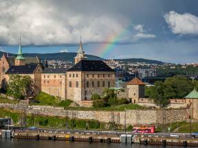
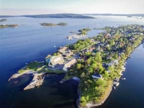
2003 FS Akershus fortress
Akershus fortress.
Upon the hillside you can see Akershus fortress. Originally built as a medieval castle in the year 1290 under the reign of King Haakon V of Norway in a response to an attack in 1287.
In the 17th century, the fortress was reconstructed by King Christian IV of Denmark and Norway. He turned Akershus into a renaissance castle and gave it the appearance it still has today. The castle has also been used as a military base, a prison and is currently the temporary office of the Prime minister of Norway. The outdoor areas of the fortress are open to the public and free of charge, you can also find restaurants, stables of the police horses, galleries and the Museum of Armed Forces and the Norwegian Resistance Museum.
Along the harbor
The green building by the water front is the Oslo Port authorities. The Port of Oslo is the largest port in Norway. Oslos container terminal receives and distributes consumer goods to most of Norway. "Half of Norway" live within a close range of 3 hours from the port, and the cargo is distributed by road or by railway.
2004 FS Very short history of Norway
Very short history of Norway
People has been living in Norway probably since before the last Ice Age. One of the most significant historical periods in Norway is the Viking Age, between 800-1050 AD. According to tradition, the territories of Norway were united around the year 885. Christianity came to Norway shortly before the year 1000. After some instability and the plague, Norway joined a union with Sweden from 1397 – 1450, then a union with Denmark, Protestantism was established after the reformation in 1536. The Danish-Norwegian Union was dissolved in 1814, when on 17th of May the same year Norway adapted its own constitution and entering a new union with Sweden until Norwegian independence in 1905.
Vippetangen
The food court in the old grain silo is called Vippetangen. This has always been an important transport hub. Fish mongers market, docks for international passenger ships, and for more than 60 years grain was transported by tram from Vippetangen to Nedre Foss Mill at Grünerløkka. There are plans to build a new tram line to Vippetangen, following the peninsula connecting Aker Brygge to Bjørvika.
Bjørvika-Havnelageret-Opera-She Lies-Munch&Munch Museum
2007 FS Bjørvika
We are now in Bjørvika. This is where Oslo was founded around the year 1050 by Harald Hardråde who also minted the country's first coin and fought to his death in the Battle of Stamford Bridge. Oslo's old town was established with the urban structure around the year 1000 and was the capital of Norway's dominion in 1314. The ongoing construction work aims to open up the waterfront to make the areas along the fjord more accessible to Oslo's inhabitants and visitors.
2008 FS Havnelageret
The pink building, often called ”The pink palace of Bjørvika” is Havnelageret, a big harbour storage building built in the period 1916-20 and designed by architect Bredo Henrik Berntsen. The construction of the building was challenging and with rising prices and wages during the First World War, it ended up coasting 3 times more than was anticipated. When Havnelageret was completed in 1921, it was the largest concrete building in Europe and the largest building in the Nordic countries. The building was so substantial that the 4th floor of Havnelageret was used as an air-raid shelter during the Second World War. Today it is used as an office building filled by financiers, ship companies and oil companies.
2009 FS Opera
The Opera house of Oslo opened in April 2008. Its award-winning design was the work of the Norwegian architectural firm Snøhetta. The opera has been built to resemble a glacier, and the main building material is Italian Carrera marble. The special design makes it possible to walk on the roof, so one can combine a stroll on the top of the building with a guided tour in English or Norwegian through some of its 1100 rooms, and with a nice meal in one of the two restaurants.
2010 FS She Lies
Moored in the water, and rotating around its own axis is the sculpture ”She Lies” by the Italian artist Monica Bonvicini. It is a three-dimensional interpretation of the German romantic painter Caspar David Friedrich's painting Das Eismeer (1823-24).
The sculpture is constantly changing due to the movements and reflecting of its surroundings.
2011 FS Edvard Munch
Edvard Munch Norway’s most famous painter, graphic artist and early representative of expressionism. Munch made his debut in 1883 and produced large quantities throughout his life with around 28,000 works. He was educated in Oslo College of Engineering.
2012 FS Munch Museum
Humbly bowing and standing 60 meters is the most recent addition to the Oslo waterfront LAMDA. The façade will give MUNCH an enigmatic and ever-changing presence in Bjørvika and reflects the fantastic lighting conditions in Oslo that are constantly changing during the day and throughout the different seasons. MUNCH is designed according to the FutureBuilt criterion of at least a 50 percent reduction in greenhouse gas emissions in the areas of transport, energy use and material use compared to current standards. The construction is designed to have a technical lifespan of 200 years. 26 724 of these are works by Munch, which consists of: Close to 1200 paintings, 7050 drawings and sketches, 18 322 graphics, with 842 different motifs, and 14 sculptures. The building also houses restaurants, view points and lecture halls and exhibition rooms.
Høvik Verk
The red brick buildings on the mainland housed a factory called Høvik Works until the 1970’s. The factory was founded by Englishmen in 1855 and grew to be a small industrial society for its workers and their families where they had their own school, grocery store and post office. Both glass and metal products were produced here, the specialties being lamps, bottles and tools. The modern buildings surrounding the old glass works is the headquarters of Det Norske Veritas, which is an independent foundation working with classification and certification of for example ships, oil platforms and ski lifts. DNV was established in Norway in 1864 with the purpose of inspecting and evaluating the technical condition of Norwegian merchant ships. Today, DNV has about 300 offices in 100 countries worldwide.
Saraholmen
Saraholmen just north of Borøya covers an area of 21 acres, and was formerly called Borøykalven. It was privately owned from 1872, and the owner named the island after his wife Sara. Saraholmen was protected in 2008 as part of the Borøya nature reserve.
Borøya
Now we can see Borøya. This is one of a few islands here in the fjord which are set aside by the authorities as a recreational area. This means that there are no private houses on the island, and anyone can use it for camping, swimming and other activities. This is an important way of ensuring that also people who do not own a house on the islands here can have access to the natural beauty and possibilities of the fjord.
2031 FS Middagsbukta / Brønnøya
Middagsbukta / Brønnøya
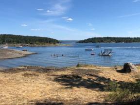
Middagsbukta translates to dinner bay and is a calm bay popular among the boat people. On 23 June, when Norwegians celebrate Midsummer, the bay can sometimes be so packed with boats that you can walk between the islands jumping from boat to boat.
The island is called Brønnøya, which means the Well Island. Back in the day, big sailing ships used to anchor here in the bay when filling fresh water from the wells. Most of the houses you can see on the island are summer cabins, but a few families live here all year long. A small cable ferry connects Brønnøya with the neighboring island, Nesøya, which is the only island in this part of the fjord connected to the mainland and therefore the only one with cars on it.
Oustøya
We are now in the western part of the Oslo fjord with many beautiful islands surrounding us. The large island next to the boat is the second largest island in the inner Oslo Fjord. It is called Oustøya and mostly consists of forest, but there are also private summer houses and already in 1964 a 18 hole golf course was established on the island. The island was named after the family Oust who lived out here for many years. Their family graveyard is on the island, and five generations of Ousts have been laid to rest there.
2029 FS Monarchy in Norway
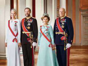
Monarchy in Norway
Norway - officially the Kingdom of Norway - adopted its own constitution in 1814. 1905, when a national referendum was held the Norwegians preferred monarchy over a republic. The throne was given to a Danish prince, Prince Carl of Denmark, who became king of a fully independent Norway. He changed his name to the more traditional name Haakon VII. He was succeeded by his only son Olav V, whose son is the current king Harald V and Haakon is Crown Prince. In a survey in 2017 it was determined that 81% of the population supports keeping the Royal Family and the constitutional monarchy.
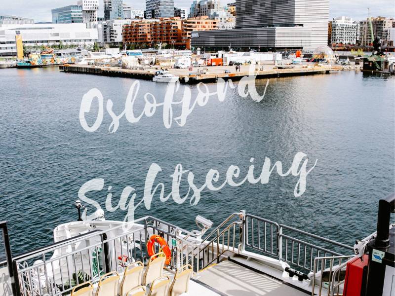
Oslofjord
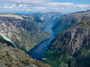
The Oslofjord has a slightly different and older origin. The valley which forms the fjord was created several million years ago by a rift in the earth's crust, followed by millions of years of volcanic activity and then erosion. Like the valleys which form the fjords in western and northern Norway, this valley then came in contact with the sea, being filled with water and forming what is now known as the Oslo Fjord.
Fjord
A fjord in Norwegian refers to a valley filled with water. Most of the Norwegian fjords, especially in the west and north of Norway, were created during the last ice age, when the whole country was covered with glaciers. Over thousands of years, the heavy glaciers would carve out deep and narrow valleys in the landscape, and when the ice melted these valleys were filled with seawater, creating the stunning fjords we see today.
2026 FS Crossing the fjord
Crossing the fjord
We are now crossing the Oslofjord – during the crossing you can see the city of Oslo to the north, and the fjord stretching out to the south. If we kept sailing south, after passing 40 islands and travelling over 100 km we would reach the open sea between Norway and Denmark, the Skagerrak.
Kavringen
We are now entering one of the most idyllic small bays here in the inner Oslo Fjord, between the islands of Kavringen and Ildjernet. The big white house on Kavringen used to be a guesthouse over a hundred years ago. There were several guesthouses along the fjord and the idea was that travelers should never have more than one day's travel between each house, so that they could get a warm meal and a bed for the night.
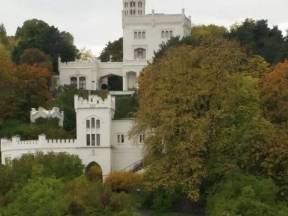
Miramare
The small white house with the columns in the hillside is popularly known as “The Temple”, but was officially named Miramare by doctor John Mjøen, who built it in 1911. Dr. Mjøen saw a similar temple when travelling in northern Italy, and imported the columns to Norway. He used the building as a summer house and for parties but sold it only six years later. Miramare was the location of the last Norwegian silent movie, “Madame visits Oslo”, in 1927.
Badehus
The small houses along the waterfront here are bathing houses, each belonging to a summer house further up the hill. They were built at a time when it was unthinkable to be seen swimming in a bikini, and much less naked. The original bathing houses were standing on poles in the water, but ice and stormy winters have destroyed many of them. A staircase ran from the door of the house down to a room with barred walls, where people would sit in the shadows and splash around in the water while they talked with their neighbors through the wall without being seen.
During the prohibition period in the 1920’s, when alcohol was strictly forbidden in Norway, the bathing houses at Nesodden were used extensively by smugglers. Being accessible by boat but not visible from Oslo, the houses were the perfect location for the illegal sale of alcohol.
Nowadays we can joyfully view them as “pearls of beauty” on a string.
Nesodden
Now passing the ferry terminal at Nesodden, with its around 17.000 people living here all year round. In the summer the population grows considerably due to the residents of the idyllic summer cabins out here. Ferries run regularly between Nesodden and the city center all year long, and the crossing only takes 20 minutes. Between 1850 and 1925, ice production was a big business in this area. The ice was produced in ponds and lakes and exported to breweries, dairies and hospitals in England.
Coastal culture
Norway is surrounded by the Barents Sea, the Norwegian Sea, the North Sea and Skagerrak. The total coastline towards the sea is approximately 2.650 km long. If you include all the fjords and islands in the calculations, Norway has over 25.000 km of coastline. A lot of the Norwegian economy and culture revolves around life by the sea, such as the oil industry, fishing, fish farming, as well as shipping.
Bunnefjorden
The part of the fjord stretching out away from the city and the main artery of the Oslo Fjord is called Bunnefjorden. This is the deepest part of the inner Oslo Fjord, more than 150 meters at the deepest point.
Oslo “Viewpoint”
From here you have a clear view over the capital and you can see all the hills surrounding it. The Highest peak ranging 630 meters. The earliest versions of Oslo’s name during the Middle Ages were spelled “Ánslo” and “Áslo” – “ás” meaning “hill”. It was then believed that Oslo’s original name meant, “the meadow beneath the hill”, the hill being the Ekeberg ridge.
2018 FS Lindøya / Nakholmen
Lindøya / Nakholmen
The two islands on the side of the boat are called Lindøya and Nakholmen. There are almost 500 small summer houses on the islands, built throughout the 20th century. The size and color of the houses is strictly regulated – as you can see, they are all painted either blue, green, red or yellow. The houses have a fantastic location, being so close to the city yet out in the fjord, and for this reason they are very popular. The opportunity to buy one is rare as they usually stay in the same family from one generation to the next.
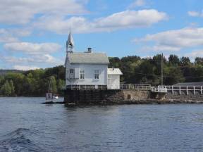
Heggholmen
The lighthouse which looks a bit like a church is Heggholmen Fyr from 1827 - the oldest lighthouse in the inner Oslo Fjord.
Gressholmen
The island Gressholmen. This was the location of Oslo's first international airport. As you can see it was not a regular airport but a seaplane base. This was the only airport in Oslo between 1927 and 1939.
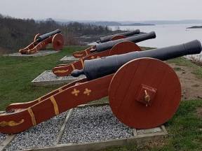
Hovedøya
The island closest to the city is Hovedøya. This island is a popular area for activities such as picnicking, sunbathing, and swimming. The Island has played an important role in the history of Oslo. Way back in the 12th century Cistercian Monks from England built a monastery on the island. Ruins are still visible today. There is a rich variety in geology and flora.
In 1640 there was a Shipyard and several of the largest ships in the Danish-Norwegian fleet were built here total of 12 large warships. In 1651, the "Sophia Amalia" was launched, then the world's largest warship.
In the 1800s the island serves as fortifications and defense of Christiania. During the Napoleonic Wars between 1807 and 1814, an advanced defense was built with two cannon positions from 1808 to cover the entrance to the city.
If you’d like to visit Hovedøya or any of the other islands here close to the city, el-ferries depart regularly from City Hall pier 4 waterfront of the City Hall.
Ekeberg park
You also find the Ekebergparken sculpture park up there. The park combines its long history, beautiful nature, stunning views and impressive sculptures in a unique way. The artworks that are spread around the park are by internationally renowned artists like Rodin, Renoir, Hirst, and Dali.
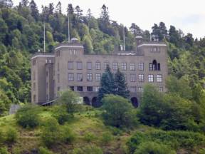
Ekeberg
The high rise area behind the “old Town” is the Ekeberg hill. It is said that Norwegian painter Edvard Munch got inspiration for his most famous painting, “The Scream”, standing at one of the viewpoints up there. Recalling a walk there with two friends in 1892, the artist summed up the moment thus: 'The sun was setting. Suddenly the sky turned blood-red. I paused, feeling exhausted, and leaned on the fence. There was blood and tongues of fire above the blue-black fjord and the city. My friends walked on, and I stood there trembling with anxiety – and I sensed an infinite scream passing through nature.’
The ”munch spot” is located close to the castle-like building that you can see up there. It is the old school of navigation for the Norwegian merchant fleet - nowadays serving as a high school.
2058 FS Ankomst Rådhusbryggen
Ankomst Rådhusbryggen
We will now be docking at the City Hall Pier. Thank you for joining the Fjord Sightseeing, have a nice day in Oslo and welcome back!
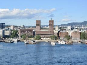
Rådhuset
In the very centre of the Oslo harbour there is a red brick building with two tall towers. This is the City Hall of Oslo, completed in 1950. The city hall is the political and administrative heart of Oslo, but it is also open to visitors. The building is decorated both inside and outside with artwork, including beautiful frescoes depicting the history of Oslo, Norway and the Norwegian constitution, by famous Norwegian artists, amongst them Edvard Munch. The city hall also houses the Nobel Peace Prize award ceremony every year on the 10th of December. If you’re interested in learning more about the Peace Prize and the life and work of Alfred Nobel, it is a good idea to pay a visit to the Nobel Peace Centre. The Peace Centre is located in the yellow building across the square from the City Hall.
Aker Brygge
The popular area Aker Brygge, is an earlier example of the principle which the Fjord City project is based on – in 1982 the shipyard Aker Mechanical Works had to close down and was replaced by the bustling shopping and restaurant area you can see today.
Tjuvholmen
The areas of the old container ports on Filipstad and Tjuvholmen are going through major changes at the moment as part of the Fjord City project, which aims to open up Oslo's harbour area to the city's population and visitors. Parts of Tjuvholmen have been redeveloped already, and during the next few years the areas will be opened up even more, with new apartment buildings, offices, a museum and even a new hotel.
Filipstad
Is still under construction. From being a docking point for containers and bulk, this area is also being made available for new apartments. Oslo is growing in population and in need of housing. This will shortly grow into a new part of the city with bars, restaurants, office buildings, shops and recreational offers like cinemas and training facilities.
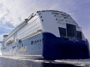
Color Line
On the opposite side of the bay is the terminal for the Color Line car and passenger ferries, which run every day between Oslo and Kiel in northern Germany. The two Color Line ferries transport more than 1 million passengers between Oslo and Kiel every year.
Oscarshall
The small castle Oscarshall is used by the royal family, but is also open to the public in the summer time. It was built around 1850 as a summer residence for King Oscar I of Sweden and Norway.
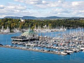
Frognerkilen
See the forest of sail masts? The bay Frognerkilen has the biggest marina for private leisure boats in Oslo. A survey showed that there are almost 1 million leisure boats in Norway, for a population of 5 million - so almost every 5th person owns some type of boat, including kayaks, canoes, sailboats etc.
Most popular are motorboats without any overnight cabins. The same survey showed that the boats are however only used an average of 28 days per year, high season is in July. The two buildings guarding the entrance to the bay are called the King and the Queen. They house offices and are also available to rent for private parties.
Dyna
The small lighthouse is called Dyna Fyr and was built in 1874. Since 1992 it has been possible to rent the house for private parties, but it’s still in use as a lighthouse and is a well-known navigation mark for sailors approaching Oslo.
Bygdøy
Bygdøy is also known as the museum island. This is where you can find the royal farm, the summer castle Oscarshall and beautiful private homes as well as six museums. On this side of the peninsula, you can find the Holocaust Centre with exhibitions about the Norwegian Jewish population during WWII.
Huk
The peninsula coming up is called Bygdøy, and from here you can see the popular beach of Huk. For generations, Oslo's inhabitants have come here for sunbathing and swimming throughout the summer season, and the beach is always crowded on nice summer days.
2042 FS Social conditions/relations
Social conditions/relations
Norway is known to be a wealthy and happy nation, with a high standard of living.
The Norwegian population is slightly more than 5 million people. It is one of the countries with the highest GDP per capita in the world, indeed in 2018 Norway is ranking nr. 5 in the world.
Norway's biggest export is crude oil and petroleum products. The current average salary in Norway is around 28 000 NOK after tax, but you have to keep in mind that the cost of living is also quite high.
The unemployment rate is a bit below 4%, as of August 2018 and poverty is quite low. The average life expectancy in Norway is above 80 years old for men and women. Norway has a universal health care system, but you can also visit private clinics. Also, schools and universities are for free, usually you just pay an administrative fee. Of course you also have private schools and universities.
The financial support you can get as a student is quite high. You also have regulations for financial support when retiring, sick, pregnant or unemployed.
Even though Norway is one of the countries with most equality between men and women, there is still quite a gap in reference to salary, full-time and part-time work as well as which they are employed in. In 2016 70% of the people employed in the public sector were female, but only about 36% in the private sector.
About 35% of leader positions are filled by women. Norway also ranks very high when it comes to transparency and absence of corruption. Immigration makes up about 14% of the population, many from Poland, Lithuania, Somalia and Sweden as well, and most of these come to Norway to work.
Oslo county has the largest amount of immigrants, more than 33% of the county's population are immigrants. In 2018 Norway was taken over by Finland as the happiest country in the world.
Rolfsbukta
You may catch a glimse of construction activity. The massive project of the underground connecting Oslo and this area is suppose to be done in 2027. The surrounding area will be apartments, church, cinemas, and the plans of building the biggest aquarium in the northerns.
This is also one of the bases for seaplanes and the flight control tower in babyblue color is a nice little restaurant.
Fornebu
On the mainland you can see an area called Fornebu, this is where the former main airport of Oslo was located before it was moved north of Oslo to Gardermoen in 1998. Fornebu has since 98`being developed as a centre for information technology and the telecom industry, and the nickname Silicon Island sits loose in the locals.
Many big companies and cooperations have their offices and headquarters here.
One to be mentioned is Equinor, formerly known as Statoil. The Norwegian state-owned multinational energy company and Norway’s largest oil and gas company have their office here at Fornebu. The architecture of the building that you can see from the boat was completed in 2012 and is inspired by offshore steel constructions. The building is made out of five lamellae of equal size, each stacked on top of one other.
Vassholmene
The two small islets just outside Snarøya are called Vassholmene. While there are people living on the inner one, the outer one is a bird sanctuary. To protect the sea birds it is forbidden to set foot on the islet during the breeding season between the 15th of April and the 15th of July.
Snarøya
We are now shoreside the peninsula of Snarøya. Most of the houses you can see here are residents. Its close to the fjord and to the city center and is considered a desirable and fashionable residential area. Back in the day when the Oslo Fjord used to freeze over regularly in wintertime, people would use Snarøya as the quickest route by which to reach the Western part of the fjord, either by foot, skates, or ski. Today, the main part of the fjord is kept open in winter by big ships and icebreakers, but during cold winters the water still freezes over along the shore and between the islands. In 2020 you could ice-skate between Snarøya to Sandvika.
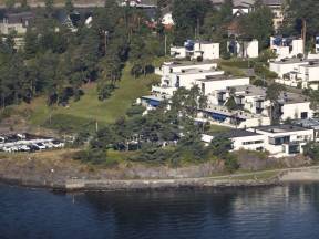
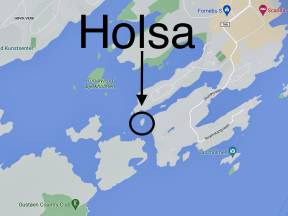
Holsa
This islets was purchased by mill owner Valentin Fürst. The mills overseer’s Martin Antonsen Holsa had his quarters here. Holsa today it is still a privately owned island.
Coal Pier
Snarøen Brug was founded in 1867 by Valentin Fürst (1831–97)
The planing mill on Snarøya, with its 240 men, was by far the largest in the region. The mill had its own store and bakery, its own school and a health insurance fund for the workers. It also built 18 workers' houses. The mill also had its own horn orchestra. A good harbor and proximity to the railway were the main reasons why the planing mill was located here. Large ships came and loaded material for export to England, France, South America and Australia. This area was covered by large boats, and along the shore lay the large storage plots. The boats were called in, hence the name Ropernveien (shout-road). The venture came to an end and all land was sold and put up for residential plots. Today, road names such as Bruksveien and Ropernveien are the only memory left of the industrial plant.
2050 FS Viking Age Museum and the Norwegian Folk Museum.
Norwegian Folk Museum, a large open-air cultural heritage and history museum.Showing how people lived in Norway from the 16th century until today. Daily life in the cities and in the countryside is presented in one of Europe's largest open-air museums. The museum has collections from all over the country, mainly from the time after the Reformation. The Viking ship house is now closed for rebuilding. In 95 years of operation, Vikingskipshuset has closed its doors - and will reopen as the viking age museum in five years. It has been absolutely crucial to build a new museum to secure the cultural heritage. The new museum will ensure optimal conditions for the objects and at the same time give the public a unique encounter with the Viking Age.
2048 FS Norwegian Maritime Museum
The Norwegian Maritime museum, a museum of Marine Archeology with maritime paintings, boats, café and terrace with fjord views.
2049 FS Kontiki Museum
The Kontiki museum houses vessels and cultural objects from Thor Heyerdahl's expeditions. Following the world-renowned, sensational Kon-Tiki expedition of 1947.
Exploring Thor Heyerdahl’s famous legacy. The man championing environmental issues and sustainability, striving for world peace and promoting deep respect for the indigenous peoples of the world.
2047 FS Fram
The Fram museum is found in the triangular buildings The Fram Museum is a museum on exhibiting the polar ship "Fram" from 1892 as the main attraction. The museum depicts the historic Norwegian polar expeditions and the three polar explorers Fridtjof Nansen, Otto Sverdrup and Roald Amundsen
2046 FS Bygdøynes
Seaway gate to Bygdøy museums. One stop is made here, on “The Museum Island”, here you can disembark for a visit to the museum. The regular bus takes you back to the city center at your own cost.
2018C FS Lindøya / Nakholmen
Lindøya / Nakholmen
The two islands on the side of the boat are called Lindøya and Nakholmen. There are almost 500 small summer houses on the islands, built throughout the 20th century. The size and color of the houses is strictly regulated – as you can see, they are all painted either blue, green, red or yellow. The houses have a fantastic location, being so close to the city yet out in the fjord, and for this reason they are very popular. The opportunity to buy one is rare as they usually stay in the same family from one generation to the next.